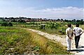
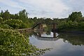
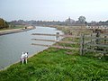
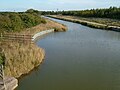
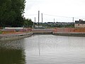
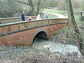
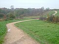
Donisthorpe Woodland Park

Last updated

Donisthorpe Woodland Park is located on Church Street, Donisthorpe in North West Leicestershire.

Contents

Description

A 36-hectare former colliery site (Donisthorpe Colliery operating between 1871 and 1990) in The National Forest. There are 20 hectares of mixed woodland and 3 km (1.9 mi) of stone-surfaced paths, which are suitable for all users. There are links to the 6 km (3.7 mi) Ashby Woulds Heritage Trail and Moira Furnace along the towpath of the restored Ashby Canal.

Ashby Woulds Trail 20190518AshbyWoulds Trail.jpg
Ashby Woulds Trail

Leicestershire County Council acquired the site in 1995 and began reclamation. The easily accessible pathways are suitable to walk (popular with dog walkers), cycle or ride horses.

Features & activities

Free car parking. Benches and picnic tables, a network of paths and permissive horse tracks. The Conkers Park Run makes use of the Park every Saturday starting at 09:00 am at Conkers using the Ashby Woulds Heritage Trail with a loop along the canal side before returning via the trail to Conkers.

Donisthorpe Woodland Park

Coordinates: 52°43′31.03″N1°31′47.76″W / 52.7252861°N 1.5299333°W / 52.7252861; -1.5299333

Related Research Articles

Moira, Leicestershire Human settlement in England

Moira is a former mining village about 2.5 miles (4 km) southwest of Ashby-de-la-Zouch in North West Leicestershire, England. The village is about 3 miles (5 km) south of Swadlincote and is close to the boundary with Derbyshire. The population is included in the civil parish of Ashby Woulds.

Ashby Canal

The Ashby-de-la-Zouch Canal is a 31-mile (50 km) long canal in England which connected the mining district around Moira, just outside the town of Ashby-de-la-Zouch, with the Coventry Canal at Bedworth in Warwickshire. It was opened in 1804, and a number of tramways were constructed at its northern end, to service collieries. The canal was taken over by the Midland Railway in 1846, but remained profitable until the 1890s, after which it steadily declined. Around 9 miles (14 km) passed through the Leicestershire coal field, and was heavily affected by subsidence, with the result that this section from Moira, southwards to Snarestone, was progressively closed in 1944, 1957 and 1966, leaving 22 miles (35 km) of navigable canal.

The National Forest (England) Environmental project in central England

The National Forest is an environmental project in central England run by The National Forest Company. From the 1990s, 200 square miles (520 km2) of north Leicestershire, south Derbyshire and southeast Staffordshire have been planted in an attempt to blend ancient woodland with newly planted areas to create a new national forest. It stretches from the western outskirts of Leicester in the east to Burton upon Trent in the west, and is planned to link the ancient forests of Needwood and Charnwood.

River Soar River in Warwickshire and Leicestershire, England

The River Soar is a major tributary of the River Trent in the English East Midlands and is the principal river of Leicestershire. The source of the river is midway between Hinckley and Lutterworth. The river then flows north through Leicester, where it is joined by the Grand Union Canal. Continuing on through the Leicestershire Soar Valley, it passes Loughborough and Kegworth until it reaches the Trent at the county boundary. In the 18th century, the Soar was made navigable, initially between Loughborough and the Trent, and then through to Leicester. It was not until the early 19th century that it was linked by the Grand Union Canal to the wider network to the south and to London.

Donisthorpe Human settlement in England

Donisthorpe is a village in the North West Leicestershire district of Leicestershire, England, historically an exclave of Derbyshire.

North West Leicestershire District in England

North West Leicestershire is a local government district in Leicestershire, England. The population of the Local Authority at the 2011 census was 93,348. Its main towns are Ashby-de-la-Zouch and Coalville.

Measham Village in Leicestershire, England

Measham is a large village in the North West Leicestershire district in Leicestershire, England, near the Derbyshire, Staffordshire and Warwickshire boundaries. It lies off the A42, 4½ miles south of Ashby de la Zouch, in the National Forest. Historically it was in an exclave of Derbyshire absorbed into Leicestershire in 1897. The name is thought to mean "homestead on the River Mease".

Willesley Human settlement in England

Willesley is a place near Ashby-de-la-Zouch. Originally in Derbyshire, it is now in north-west Leicestershire. In the 19th century it had a population of about 60 and Willesley Hall was the home of the Abney and later the Abney-Hastings family. Willesley is so small that it would be a hamlet except that it has a church.

Walking in London

Walking is a popular recreational activity in London, despite traffic congestion. There are many streets that provide interesting walks, especially within historic central London, In addition there are attractive commons, parks, canals, and disused railway tracks that provide space for walks. This includes Wimbledon Common, Epping Forest, Hampstead Heath, and the eight Royal Parks: Hyde Park, Regent's Park, Richmond Park, etc. In recent years access to canals and rivers, including the Regent's Canal, and the River Thames has been greatly improved, and as well a number of long-distance walking routes have been created that link green spaces.

Snarestone is a small rural village in North West Leicestershire, England.

Ellistown is a village about 2 miles (3 km) south of Coalville in North West Leicestershire, England. It is named after Colonel Joseph Joel Ellis who died in 1885. The population from the 2011 census was included in the civil parish of Ellistown and Battleflat.

Snibston

Snibston is an area east of Ravenstone, north west Leicestershire, in the English Midlands. Originally rural, part of Snibston was transformed into a coal mining village by the opening of coal mines by the Snibston Colliery Company in the early 1830s. This industrial part of Snibston was subsequently subsumed into the developing town of Coalville, though small rural areas of Snibston survive within the civil parishes of Ravenstone with Snibston and Hugglescote and Donington le Heath. In the part of Snibston within the latter civil parish stands the 13th-century church of St Mary, noted as the smallest church still in use for regular worship in England. The main Snibston Colliery was sunk in 1831, and after its closure the Snibston Country Park with the Snibston Discovery Museum was built on part of the colliery site. Part of the park is Snibston Grange Local Nature Reserve. The population is included in the civil parish of Ravenstone with Snibston.

Overseal Human settlement in England

Overseal is a village and civil parish in South Derbyshire, 3 miles (4.8 km) south of Swadlincote, 4.5 miles (7.2 km) west of Ashby-de-la-Zouch and 12.5 miles (20.1 km) due south-southwest of Derby. The population of the civil parish at the 2011 census was 2,450. Situated within the National Forest area, it is one of the southernmost settlements in Derbyshire, close to the border with Leicestershire.

Coleorton Human settlement in England

Coleorton is a village and civil parish in North West Leicestershire, England. It is situated on the A512 road approximately 2 miles (3.2 km) east of Ashby de la Zouch. Nearby villages include Newbold, to the north, Thringstone to the east, and Swannington to the south-east.

Coleorton Wood is woodland in the village of Coleorton, near Coalville in North West Leicestershire, England. It is a six-hectare (15-acre) mixed woodland that was planted during the early days of the National Forest. The site was formerly Coleorton Pit, or colliery, which opened in 1875, and closed in the 1930s. It gained the local nickname of 'Bug and Wink' colliery.

Sheet Hedges Wood

Sheet Hedges Wood is in the parish of Newtown Linford, and lies some 1-mile (1.6 km) north of Groby, in Leicestershire, UK. The site is made up of two areas of woodland and a meadow field, all with public access, extending 29 acres (120,000 m2). The woodland block is adjacent to the road includes a car park and access trails.

Ashby Woulds Heritage Trail

The Ashby Woulds Heritage Trail is a footpath and cycleway along what was formerly the Ashby and Nuneaton railway line between Spring Cottage and Measham, Leicestershire, England, a distance of some 6 km (3.7 mi). There are links to Donisthorpe woodland park, Moira Furnace and Conkers, the main visitor centre for The National Forest, in which the trail now lies.

National Cycle Route 63 is a route of the National Cycle Network, running from Burton on Trent to Wisbech.

Ticknall Tramway

The Ticknall Tramway was a 12.8 mi (20.6 km) long 4 ft 2 in gauge horse-drawn plateway terminating at Ticknall, Derbyshire, England. It operated from 1802 to 1913.