Look up dorp in Wiktionary, the free dictionary.
Dorp means "village" in Dutch and Afrikaans. It may refer to:
Dorp means "village" in Dutch and Afrikaans. It may refer to:

Zoetermeer is a city in the Western Netherlands, in the province of South Holland. The municipality covers an area of 37.05 km2 (14.31 sq mi) of which 2.60 km2 (1.00 sq mi) is water. A small village until the late 1960s, it had 6,392 inhabitants in 1950. By 2023 this had grown to 126.998, making it the fourth largest population centre in the province of South Holland, after Rotterdam, The Hague and Leiden. While now a city in its own right, Zoetermeer started out as a suburb of The Hague and is still a part of the Greater The Hague urban area.

Staten Island is the southernmost borough of New York City, coextensive with Richmond County and situated at the southernmost point of New York. The borough is separated from the adjacent state of New Jersey by the Arthur Kill and the Kill Van Kull and from the rest of New York by New York Bay. With a population of 495,747 in the 2020 Census, Staten Island is the least populated New York City borough but the third largest in land area at 58.5 sq mi (152 km2); it is also the least densely populated and most suburban borough in the city.
Nassau may refer to:
Oakwood may refer to:

New Dorp is a neighborhood on the South Shore of Staten Island, New York City, United States. New Dorp is bounded by Mill Road on the southeast, Tysens Lane on the southwest, Amboy and Richmond Roads on the northwest, and Bancroft Avenue on the northeast. It is adjacent to Oakwood to the southwest, Todt Hill to the northwest, Dongan Hills and Grant City, and Midland Beach and Miller Field to the southeast. New Dorp Beach, bordering to the east, is often listed on maps as a separate neighborhood from Mill Road to the shore of Lower New York Bay, but is generally considered to be a part of New Dorp.

Midland Beach is a neighborhood of Staten Island in New York City. It lies along the east-central coast of the island, in the area known locally as the "Mid-Island, Staten Island" or the "East Shore".

The term East Shore is frequently applied to a series of neighborhoods along the Lower New York Bay and the Raritan Bay and within New York City's borough of Staten Island.
Mid-Island is frequently applied to a series of neighborhoods within the New York City borough of Staten Island.

Oakwood is a neighborhood located in east central Staten Island, New York City, near the South Shore. It is bordered by Tysens Lane (north); the Atlantic Ocean (east); Great Kills Park (south); Kensico Street, and Clarke Avenue (west).

Dongan Hills is a neighborhood located within the New York City borough of Staten Island. It is on the island's East Shore. Dongan Hills is bounded by Laconia Avenue to the southeast, Jefferson Avenue on the southwest, Richmond Road on the northwest, and Old Town Road to the north. It is adjacent to New Dorp and Grant City to the southwest, Todt Hill to the northwest, Old Town/Concord to the northeast, and South Beach and Midland Beach to the southeast.
The New York City Farm Colony was a poorhouse on the New York City borough of Staten Island, one of the city's five boroughs. It was located across Brielle Avenue from Seaview Hospital, on the edge of the Staten Island Greenbelt.
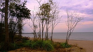
New Dorp Beach is along the shore of the neighborhood of New Dorp, on Staten Island, one of the five boroughs of New York City. It is between Midland Beach and Oakwood Beach.
Miller Field may refer to:
New Dorp High School, commonly referred to as New Dorp or NDHS, is a public school on the East Shore of the New York City borough of Staten Island in the New Dorp neighborhood. The school is administered by the New York City Department of Education. The school is located at 465 New Dorp Lane next to Miller Field, an army airport turned park, which extends to the Lower New York Bay. New Dorp High School is located in Region 7, which encompasses all of Staten Island and portions of southwest Brooklyn.

The New Dorp station is a Staten Island Railway station in the neighborhood of New Dorp, Staten Island, New York. The station became fully compliant with the Americans with Disabilities Act of 1990 in 2023.
Hylan Boulevard is a major northeast-southwest boulevard in the New York City borough of Staten Island, and the longest street in a single borough in the city. It is approximately 14 miles (23 km) long, and runs from the North Shore neighborhood of Rosebank, then along the entire East Shore, to the South Shore neighborhood of Tottenville. It was renamed in 1923 for New York City mayor John F. Hylan, before which it was known as Southfield Boulevard and the northern segment as Pennsylvania Avenue.

Staten Island Community Board 2 is a local government unit of the city of New York, encompassing the Staten Island neighborhoods of Arrochar, Bloomfield, Bulls Head, Chelsea, southern Castleton Corners, Dongan Hills, Egbertville, Emerson Hill, southern Graniteville, Grant City, Grasmere, Heartland Village, Midland Beach, New Dorp, New Springville, Oakwood, Ocean Breeze, Old Town, South Beach, Todt Hill, Travis, and southern Willowbrook.
The Boulevard, formerly Hylan Plaza, is an open-air shopping center in the New Dorp neighborhood of Staten Island, New York City, United States.