Related Research Articles

The Gulf Intracoastal Waterway is the portion of the Intracoastal Waterway located along the Gulf Coast of the United States. It is a navigable inland waterway running approximately 1,050 mi (1,690 km) from Carrabelle, Florida, to Brownsville, Texas.

The Battle of Bayou Fourche was a minor military engagement of the American Civil War, and the principal engagement of the Little Rock Campaign. The conflict was fought on September 10, 1863, in Pulaski County, Arkansas, near the Bayou Fourche, and was the culmination of a month-long offensive launched by U.S. Army Major-General Frederick Steele on August 1, 1863, to capture the capital of Arkansas. The campaign included engagements at West Point, Harrison's Landing, Brownsville, Bayou Meto, and Ashley's Mills.

In usage in the United States, a bayou is a body of water typically found in a flat, low-lying area, and can be either an extremely slow-moving stream or river, or a marshy lake or wetland. The term bayou can also refer to a creek whose current reverses daily due to tides and which contains brackish water highly conducive to fish life and plankton. Bayous are sometimes paved to help prevent flooding. Bayous are commonly found in the Gulf Coast region of the southern United States, notably the Mississippi River Delta, with the states of Louisiana and Texas being famous for them. A bayou is frequently an anabranch or minor braid of a braided channel that is moving much more slowly than the mainstem, often becoming boggy and stagnant. Though fauna varies by region, many bayous are home to crawfish, certain species of shrimp, other shellfish, catfish, frogs, toads, American alligators, American crocodiles, herons, turtles, spoonbills, snakes, leeches, and many other species.

Bayou Lafourche, originally called Chetimachas River or La Fourche des Chetimaches,, is a 106-mile-long (171 km) bayou in southeastern Louisiana, United States, that flows into the Gulf of Mexico. The bayou is flanked by Louisiana Highway 1 on the west and Louisiana Highway 308 on the east, and is known as "the longest Main Street in the world." It flows through parts of Ascension, Assumption, and Lafourche parishes. Today, approximately 300,000 Louisiana residents drink water drawn from the bayou.
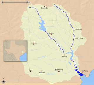
The San Jacinto River runs from Lake Houston in Harris County, Texas, to Galveston Bay. In the past, it was home to the Karankawa and Akokisa tribes. It is named after Saint Hyacinth.
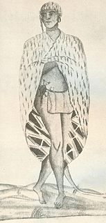
The Atakapa are an indigenous people of the Southeastern Woodlands, who spoke the Atakapa language and historically lived along the Gulf of Mexico. Europeans adopted this name from the competing Choctaw people, whom they first encountered. The Atakapan people, made up of several bands, called themselves the Ishak, pronounced "ee-SHAK", which translates as "The People." Within the tribe, the Ishak identified as "The Sunrise People" or "The Sunset People", two moieties. Although the people were decimated by infectious disease after European contact and declined as a tribe, survivors joined other tribes. Their descendants still live in southern Louisiana and Texas. People identifying as Atakapa-Ishak had a gathering in 2006.

Buffalo Bayou is a slow-moving river which flows through Houston in Harris County, Texas. Formed 18,000 years ago, it has its source in the prairie surrounding Katy, Fort Bend County, and flows approximately 53 miles (85 km) east through the Houston Ship Channel into Galveston Bay and the Gulf of Mexico. In addition to drainage water impounded and released by the Addicks and Barker reservoirs, the bayou is fed by natural springs, surface runoff, and several significant tributary bayous, including White Oak Bayou, Greens Bayou, and Brays Bayou. Additionally, Buffalo Bayou is considered a tidal river downstream of a point 440 yards (400 m) west of the Shepherd Drive bridge in west-central Houston.

Johnson Bayou is a small unincorporated community located on the Creole Nature Trail along the Gulf Coast in Cameron Parish, Louisiana, United States, and is named after Daniel Johnson, who came to the area circa 1790. The village is spread across coastal chenieres which were formed by deltaic sedimentation by the shifting of the Mississippi River. This geologic formation, the coastal cheniere, is found only in a few locations across the globe. The population of the community is approximately 400.

The Houston Ship Channel, in Houston, Texas, is part of the Port of Houston, one of the US's busiest seaports. The channel is the conduit for ocean-going vessels between Houston-area terminals and the Gulf of Mexico, and it serves an increasing volume of inland barge traffic.

Houston, the most populous city in the Southern United States, is located along the upper Texas Gulf Coast, approximately 50 miles (80 km) northwest of the Gulf of Mexico at Galveston. The city, which is the ninth-largest in the United States by area, covers 601.7 square miles (1,558 km2), of which 579.4 square miles (1,501 km2), or 96.3%, is land and 22.3 square miles (58 km2), or 3.7%, is water.

White Oak Bayou is a slow-moving river in Houston, Texas. A major tributary of the city's principal waterway, Buffalo Bayou, White Oak originates near the intersection of Texas State Highway 6 and U.S. Highway 290 and meanders southeast for 25 miles (40 km) until it joins Buffalo Bayou in Downtown. The river serves as a greenway which connects Downtown to the Houston Heights, Oak Forest, Garden Oaks, and Inwood Forest.

Bayou Bend Collection and Gardens, located in the River Oaks community in Houston, Texas, United States, is a 14-acre (57,000 m2) facility of the Museum of Fine Arts, Houston (MFAH) that houses a collection of decorative art, paintings and furniture. Bayou Bend is the former home of Houston philanthropist Ima Hogg. Bayou Bend was marked with a Texas Historical Commission marker in 1973 and was listed in the National Register of Historic Places in 1979.

Double Bayou is an unincorporated community in Chambers County, Texas, United States.
Armand Bayou is a bayou in U.S. State of Texas. It runs near Galveston Bay in Pasadena and the Clear Lake Area.

Cross Bayou is a 38.0-mile-long (61.2 km) river in Texas and Louisiana. It is a tributary of the Red River, part of the Mississippi River watershed.
Double Bayou, East Fork is a river in Texas.
Pecan Bayou is a slow-moving stream in Callahan County, Texas. The stream is fed by over twenty creeks and is one of the major tributaries of the Colorado River in Texas. It may be the westernmost bayou in the United States. A dam on Pecan Bayou seven miles north of Brownwood forms Lake Brownwood.
Pine Island Bayou is a bayou in Texas.

Brays Bayou is a slow-moving river in Harris County, Texas. A major tributary of Buffalo Bayou, the Brays flows for 31 miles (50 km) from the western edge of the county, south of Barker Reservoir along the border with Fort Bend County, east to its convergence with the Buffalo at Harrisburg. Nearly all of the river is located within the city of Houston; it is a defining geographic feature of many neighborhoods and districts, including Meyerland, Braeswood Place, the Texas Medical Center, and Riverside Terrace.
References
- "An Analysis of Texas Waterways" . Retrieved 2006-05-04.
- USGS Hydrologic Unit Map - State of Texas (1974)
| This article related to a river in Texas is a stub. You can help Wikipedia by expanding it. |