
Albania is a small country in Southern and Southeastern Europe strategically positioned on the Adriatic and Ionian Sea inside the Mediterranean Sea, with a coastline of about 476 km (296 mi). It is bounded by Montenegro to the northwest, Kosovo to the northeast, North Macedonia to the east and Greece to the southeast and south.
Dibër County is one of the 12 counties of the Republic of Albania, spanning a surface area of 2,586 square kilometres (998 sq mi) with the capital in Peshkopi. The county borders on the counties of Durrës, Elbasan, Kukës, Lezhë, Tirana and the country of North Macedonia. It is divided into four municipalities, including Bulqizë, Dibër, Klos and Mat.. The municipalities are further subdivided into 290 towns and villages in total.
Kukës County is a landlocked county in northeastern Albania, with the capital in Kukës. The county spans 2,374 square kilometres (917 sq mi) and had a total population of 84,035 people as of 2016. The county borders on the counties of Dibër, Lezhë and Shkodër and the countries of Kosovo and North Macedonia. It is divided into three municipalities, including Has, Kukës and Tropojë. The municipalities are further subdivided into 290 towns and villages in total.

The Black Drin, or Black Drim is a river in North Macedonia and Albania. It flows out of Lake Ohrid in Struga, North Macedonia. It is 149 km (93 mi) long and its drainage basin is 3,504 km2 (1,353 sq mi). Its average discharge is 118 m3/s (4,200 cu ft/s). After about 56 km (35 mi) it crosses the border to Albania, west of Debar, North Macedonia. It merges with the White Drin in Kukës to form the Drin, which flows into the Adriatic Sea. It drains most of the eastern border region of Albania.

The Erenik is a river in Kosovo. Located in the western Kosovo, it's a 51 km (32 mi)-long right tributary to the White Drin river.

The White Drin or White Drim is a river in Kosovo and northern Albania, a ca. 140-kilometre (87 mi)-long headstream of the Drin.

The Radika is a river in southern Kosovo and western Macedonia, a 70 km (43 mi)-long right tributary to the Black Drin river.

The Valbona is a river in northern Albania. It is still relatively untouched. Its source is in the Prokletije, near the border with Montenegro.

The Fierza Hydroelectric Power Station is a large hydroelectric power station on the Drin River, in Albania.
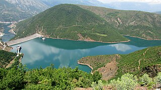
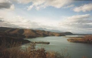
The Fierza Reservoir is a reservoir in Albania and Kosovo. The Drin River and parts of the White Drin and Black Drin also runs through the reservoir. The size of the lake is 72.6 km2 (28.0 sq mi), of which 2.46 km² belong to Kosovo. It is 70 km long and has a depth of 128 m. In the Albanian side of the lake there are many canyons and some small islands. The dam is 167m tall. In 2014, the lake was declared a Regional Nature Park by the Kukes County Council.

Korab is a mountain range in the eastern corner of Albania and the western part of North Macedonia, running along the border between both countries. It forms also the European Green Belt. In Albania, it is also called Vargu lindor, but this term encompasses mountains further north, such as the Koritnik and Gjallica. The highest peak is Mount Korab at 2,751 m (9,026 ft) above sea level. With a prominence of 2,169 m (7,116 ft), Korab is the 18th most prominent mountain peak in the European continent. The mountains are composed of sedimentary rock, including shale, sandstone, dolomite and limestone. The name refers to a Paleochristian sea god.

The Central Mountain Range is a physiogeographical region encompassing the central and eastern edge of Albania. It comprises the mountainous inland extending all the way from the valley of Drin and the mountains of Sharr, Skanderbeg, Korab, and Shebenik-Jabllanicë, through the lakes of Ohrid and Prespa, until it reaches the village of Ersekë and the mountains of Pindus close to the border between the country and Greece.
The Northern Mountain Range is a geographical region in northern Albania. It is one of the four main regions of Albania, the others being Central Mountain Range, Southern Mountain Range, and Western Lowlands. The northern range encompasses the Albanian Alps extending from the Lake Shkodër shared with Montenegro in the northwest through the Valbonë Valley to the Drin Valley in the east. The area falls within the Dinaric Mountains mixed forests and Balkan mixed forests terrestrial ecoregions of the Palearctic Temperate broadleaf and mixed forests.

Dibër is a municipality in Dibër County, northeastern Albania. It was created in 2015 by the merger of the former municipalities Arras, Fushë-Çidhën, Kala e Dodës, Kastriot, Lurë, Luzni, Maqellarë, Melan, Muhurr, Peshkopi, Selishtë, Sllovë, Tomin, Zall-Dardhë and Zall-Reç. The seat of the municipality is the town Peshkopi. The total population is 61,619, in a total area of 937.88 km2. It is coterminous with the former Dibër District.
The Dibër valley is a section of the Drin valley in the border region between North Macedonia and Albania.

The Albanian Power Corporation is the largest electricity producing company in Albania. KESH operates the most important electricity generating plants in the country. They include: The Drin River Cascade hydropower plants, with an installed power capacity of 1,350 MW, and the Vlora TPP, with an installed power capacity of 98 MW. The cascade, built on the Drin River, is the largest in the Balkan region by installed capacity, as well as by the size of the hydropower plants.

Lake Koman is a reservoir on the Drin River in northern Albania. Lake Koman is surrounded by dense forested hills, vertical slopes, deep gorges, and a narrow valley, completely taken up by the river. Besides the Drin, it is fed by the Shala and Valbona Rivers. The lake stretches in an area of 34 km2 (13 sq mi), its width being 400 m (0.25 mi). The narrowest gorge, which is surrounded by vertical canyon walls, is more than 50 m (0.031 mi) wide. The reservoir was constructed between 1979 and 1988 near the village of Koman with a height of 115 m (377 ft).


