Drummond/North Elmsley

Last updated

Drummond/North Elmsley
Township of Drummond/North Elmsley
Richardson Ontario.jpg
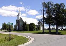
St. Augustine's Anglican Church in Richardson.
Landne.PNG
Drummond/North Elmsley within Lanark County.
Canada Southern Ontario location map 2.png
Red pog.svg
Drummond/North Elmsley
Coordinates: 44°58′N76°12′W / 44.967°N 76.200°W / 44.967; -76.200
Country Flag of Canada (Pantone).svg  Canada
Province Flag of Ontario.svg  Ontario
County Lanark
IncorporatedJanuary 1, 1998
Government
  TypeTownship
  ReeveStephen M. Fournier
  Governing BodyDrummond/North Elmsley Township Council
   MP Scott Reid  (CPC)
   MPP John Jordan  (OPC)
Area
[1]
  Land366.13 km2 (141.36 sq mi)
Population
 (2016) [1]
  Total8,183
  Density21.2/km2 (55/sq mi)
Time zone UTC-5 (EST)
  Summer (DST) UTC-4 (EDT)
Postal code FSA
K7H
Area code(s) 613, 343
Website http://www.dnetownship.ca

Drummond/North Elmsley is a township in eastern Ontario, Canada in Lanark County. It is situated on the north shore of the Rideau River between the town of Perth and the town of Smiths Falls. It is a predominantly rural municipality. The township offices are located in the hamlet of Port Elmsley.

Contents

History

The township, covering 366.03 km2, was formed on January 1, 1998, through the merger of Drummond Township and North Elmsley Township.

Communities

The township comprises the communities of Armstrong Corners, Balderson, Beveridge Locks, Cook's Shore, Craig Shore, Drummond Centre, Ebbs Shore, Elmgrove, Ferguson Falls, Glenview, Innisville, McCreary's Shore, McCulloughs Landing, McNaughton Shore, Port Elmsley, Prestonvale, Richardson, Rideau Ferry, Robertson's Shore and Wayside.

Geography and ecology

The most common landscape is gently rolling Canadian shield, predominantly gneiss. The valleys often have clay or sand deposits from events near the end of the last ice age. At one point near the end of the last ice age, the Champlain Sea flooded the Ottawa valley as far inland as what is now the town of Perth. [2] West of Perth along Highway 7 one can see a remnant of this clay plain. An old shoreline of the Champlain Sea crosses Highway 7 near Ramsay Concession 2 before winding south into Drummond/North Elmsley. North of Perth, this clay plain is occupied by the huge Blueberry Marsh. [3]

The hard rock and thin soil produced distinctive deciduous forests dominated by maple, oak, beech, ash and pine. Southern trees like hickory and butternut are less common. Wetter areas have elm, silver maple and white cedar. Hemlock was much more common in the past, but logging for bark used in tanning has much depleted this species. [4] Only a few large hemlock stands remain, although there are many scattered trees through the remaining forests. Natural forest fires from lightning created some fire barrens in the southern parts of the township. [5] Generally speaking, settlers cleared the deeper pockets of soil, and the clay plains. This produced the distinctive landscape with fields surrounded by forested uplands. The stone piles along the edge of the field illustrate the labour involved in creating agricultural land here. The many outcrops of Canadian shield in fields are also a reminder of just how close to the surface bed rock remains.

The Mississippi River and the Rideau River have extensive areas of wetland. The less flooded areas tend to have silver maple swamp, while lower on the shoreline are marshes and aquatic plants. One of the largest wetlands is the Innisville wetland, a provincially significant wetland that formed upstream from Mississippi Lake. Other familiar wetlands include the Tay Marsh (south of Perth) and The Swale (near Smiths Falls). Both rivers are popular with canoeists and naturalists. Smaller wetlands occur throughout the county; many are produced by beavers. Beaver ponds are an important as they provide habitat for a great many kinds of species, including frogs, turtles, otters, muskrats and migratory waterfowl. Beaver ponds provide a cycle of flooding, from shallow water through to wet meadow, and most phases of pond ecology can be seen driving the township roads. [6]

Owing to its location—the combination of two large rivers, wetlands and forests—the county has a rich array of wildlife, and wildlife viewing is a popular activity. Significant animal species include the black rat snake (now officially renamed the Gray ratsnake by experts on this species) and the Blanding's turtle.

Transportation

The north-south Ontario Highway 7 passes through the township from Perth towards Carleton Place. The east-west County Road 43 goes between Perth and Smiths Falls.

The Rideau Trail passes through the township twice, between Smiths Falls and Perth and to the south of Perth.

Demographics

In the 2021 Census of Population conducted by Statistics Canada, Drummond/North Elmsley had a population of 8,183 living in 3,287 of its 3,708 total private dwellings, a change of 5.3% from its 2016 population of 7,773. With a land area of 365.67 km2 (141.19 sq mi), it had a population density of 22.4/km2 (58.0/sq mi) in 2021. [7]

Canada census – Drummond/North Elmsley community profile
2021 2016 2011
Population8,183 (+5.3% from 2016)7,773 (+3.8% from 2011)7,487 (+5.2% from 2006)
Land area365.67 km2 (141.19 sq mi)366.13 km2 (141.36 sq mi)366.03 km2 (141.32 sq mi)
Population density22.4/km2 (58/sq mi)21.2/km2 (55/sq mi)20.5/km2 (53/sq mi)
Median age50.8 (M: 50.4, F: 50.8)49.6 (M: 49.4, F: 49.9)
Private dwellings3,708 (total)  3,287 (occupied)3,607 (total) 3,478 (total) 
Median household income$98,000$81,303
References: 2021 [8] 2016 [9] 2011 [10] earlier [11] [12]
Historical populations
YearPop.±%
2001 6,670    
2006 7,118+6.7%
2011 7,487+5.2%
2016 7,773+3.8%
[13] [14] [1]

Places of interest

See also

Related Research Articles

<span class="mw-page-title-main">Perth, Ontario</span> Town in Ontario, Canada

Perth is a town in Eastern Ontario, Canada. It is located on the Tay River, 83 kilometres (52 mi) southwest of Ottawa, and is the seat of Lanark County.

<span class="mw-page-title-main">Carleton Place</span> Town in Ontario, Canada

Carleton Place is a town in Eastern Ontario, Canada, in Lanark County, about 46 kilometres (29 mi) west of downtown Ottawa. It is located at the crossroads of Highway 15 and Highway 7, halfway between the towns of Perth, Almonte, Smiths Falls, and the nation's capital, Ottawa. Canada's Mississippi River, a tributary of the Ottawa River flows through the town. Mississippi Lake is just upstream by boat, as well as by car.

<span class="mw-page-title-main">Thousand Islands – Frontenac Arch</span> Geologic region in North America

The Thousand Islands – Frontenac Arch region or the Frontenac Axis is an exposed strip of Precambrian rock in Canada and the United States that links the Canadian Shield from Algonquin Park with the Adirondack Mountain region in New York, an extension of the Laurentian mountains of Québec. The Algonquin to Adirondacks region, which includes the Frontenac Axis or Arch, is a critical linkage for biodiversity and resilience, and one with important conservation potential. The axis separates the St. Lawrence Lowlands and the Great Lakes Lowlands. It has many distinctive plant and animal species. It is one of four ecoregions of the Mixedwood Plains.

<span class="mw-page-title-main">Smiths Falls</span> Town in Ontario, Canada

Smiths Falls is a town in Eastern Ontario, Canada, 72 kilometres (45 mi) southwest of Ottawa. As of the 2021 census it has a population of 9,254. It is in the Census division for Lanark County, but is separated from the county. The Rideau Canal waterway passes through the town, with four separate locks in three locations and a combined lift of over 15 metres (49.2 ft).

<span class="mw-page-title-main">United Counties of Leeds and Grenville</span> County in Ontario, Canada

The United Counties of Leeds and Grenville, commonly known as Leeds and Grenville, is a county in Ontario, Canada, in the Eastern Ontario subregion of Southern Ontario. It fronts on the Saint Lawrence River and the international boundary between Canada and the United States, opposite of the State of New York. The county seat is Brockville. The county was formed by the union of the historical counties of Leeds and Grenville in 1850.

<span class="mw-page-title-main">Montague, Ontario</span> Township in Ontario, Canada

Montague is a township in eastern Ontario, Canada, in Lanark County on the Rideau River. The township administrative offices are located on Roger Stevens Drive east of Smiths Falls.

<span class="mw-page-title-main">Beckwith, Ontario</span> Township in Ontario, Canada

Beckwith is a township in eastern Ontario, Canada. It is located in Lanark County on the Mississippi River. It is located within Canada's National Capital Region.

<span class="mw-page-title-main">Mississippi River (Ontario)</span> Tributary of the Ottawa River in Ontario, Canada

The Mississippi River is a tributary of the Ottawa River in Eastern Ontario, Canada which has no relation with the Mississippi River in the United States. It is 200 kilometres (120 mi) in length from its source at Mackavoy Lake, has a drainage area of 4,450 square kilometres (1,720 sq mi), and has a mean discharge of 40 cubic metres per second (1,400 cu ft/s). There are more than 250 lakes in the watershed.

<span class="mw-page-title-main">Lanark County</span> County in Ontario, Canada

Lanark County is a county located in the Canadian province of Ontario. Its county seat is Perth, which was first settled in 1816 and was known as a social and political capital before being over shadowed by what we now know as Ottawa.

<span class="mw-page-title-main">Tay Valley, Ontario</span> Township in Ontario, Canada

Tay Valley is a township in eastern Ontario, Canada, on the Tay River in the southwest corner of Lanark County, adjacent to the United Counties of Leeds and Grenville and Frontenac County. The township administrative offices are located in Glen Tay.

<span class="mw-page-title-main">South Frontenac</span> Township in Ontario, Canada

South Frontenac is a township in Frontenac County in eastern Ontario, Canada. It was amalgamated in 1998 from the former townships of Bedford, Loughborough, Portland, and Storrington.

Leeds County is a historic county in the Canadian province of Ontario. The county was first surveyed in 1792 as one of the nineteen counties created by Sir John Graves Simcoe in preparation for the United Empire Loyalists to settle here. The county took its name from Francis Osborne, 5th Duke of Leeds; the "Leeds" of the Dukedom referred to Leeds in West Yorkshire, England and not for Leeds, Kent, England. In 1850, Leeds County merged with Grenville County to create the United Counties of Leeds and Grenville. This county was home to several townships as well as the city of Brockville.

Lanark South was a federal electoral district represented in the House of Commons of Canada from 1867 to 1917. It was located in the province of Ontario. It was created by the British North America Act of 1867 which divided the County of Lanark into two ridings: Lanark South and Lanark North.

<span class="mw-page-title-main">Big Rideau Lake</span>

Big Rideau Lake is a lake in the municipalities of Tay Valley and Drummond/North Elmsley, Lanark County and Rideau Lakes, United Counties of Leeds and Grenville in Eastern Ontario, Canada. The lake is on the border between the two counties, 72 kilometres (45 mi) to the southwest of Ottawa. It is 32 kilometres (20 mi) long and is 6 kilometres (3.7 mi) wide, is much narrower at its northeastern end than at its southwestern end, and is part of the Saint Lawrence River drainage basin. It is the largest lake on the Rideau Canal, which was designated a UNESCO world heritage site in 2007.

Rideau Ferry is a small community in Eastern Ontario, Canada, along the Rideau Waterway. Rideau Ferry straddles a narrow stretch of water joining the Big Rideau Lake to the Lower Rideau Lake. At Rideau Ferry, the south shore of the Rideau Waterway is located within the Township of Rideau Lakes in Leeds and Grenville County, and the north shore is located within the township of Drummond/North Elmsley in Lanark County.

<span class="mw-page-title-main">Rideau Lakes</span> Township in Ontario, Canada

Rideau Lakes is a township located within Leeds and Grenville United Counties in Eastern Ontario, Canada. The township was incorporated on 1 January 1998 by amalgamating the former townships of North Crosby, South Crosby, Bastard, South Burgess and South Elmsley with the village of Newboro.

<span class="mw-page-title-main">Leeds and the Thousand Islands</span> Township in Ontario, Canada

Leeds and the Thousand Islands is a township in the Canadian province of Ontario, located within the United Counties of Leeds and Grenville. The township is located along the Saint Lawrence River, and extends north into rural hamlets and villages. Formerly, this township was divided into three separate townships: Leeds, Lansdowne, and Escott townships; these townships amalgamated to form the current township of Leeds and the Thousand Islands.

Mississippi Lake is a lake in Lanark County in Ontario, Canada, about 60 km southwest of Ottawa. It is a shallow and narrow lake, about 10 m deep at its deepest, 16 km in length, and less than one km wide in most places. Around the shoreline are over 1,000 homes, ranging from small cabins, to larger vacation homes, to full-time residences, many of them accessed by private roads. There are also several campground resorts, with RVs, waterfront condos, or rentals.

<span class="mw-page-title-main">Keddy Nature Sanctuary</span>

The Keddy Nature Sanctuary consists of approximately one square mile of forest and wetland on the very edge of the Canadian shield, just an hour west of Ottawa on the east side of Lanark County, in Ontario, Canada. It is mostly second growth temperate deciduous forest, interspersed with wetlands and beaver ponds, as well as sedge-dominated rock-ridges. A central ridge has more than twenty hectares of hemlock forest. There are also old fields that remain from pastures created in the previous century. Parts of this property, as well as adjoining lands, are designated as the Scotch Corners Provincially Significant Wetland. The property is one of several protected by the Mississippi Madawaska Land Trust.

<span class="mw-page-title-main">Scotch Corners Wetland</span> Wetland Area in Ontario

Scotch Corners Wetland is a provincially significant wetland complex located in Lanark County, Ontario, Canada. The 202 hectares area has a wide array of wetland types including swamps, marshes, vernal pools, beaver ponds and seepage areas. It forms the headwaters of several creeks that drain into Mississippi Lake.

References

  1. 1 2 3 "Census Profile, 2021 Census of Population: Drummond/North Elmsley, Township". Statistics Canada. 1 February 2023. Retrieved September 29, 2023.
  2. Chapman, L.J. and D.F. Putnam. 1951. The Physiography of Southern Ontario. University of Toronto Press, Toronto. 284 p. plus map in four sections.
  3. Keddy, P.A. 2008. Earth, Water, Fire. An Ecological Profile of Lanark County. General Store Publishing House, Refrew, Ontario. Map 14.
  4. Keddy, C.J. 1993. Forest History of Eastern Ontario. A report prepared for the Eastern Ontario Forest Group.
  5. Catling, Paul M and Vivian R. Brownell. 1999. The flora and ecology of southern Ontario granite barrens. Pages 392-405 in Anderson, R.C., J.S. Fralish, and J.M. Baskin (eds). Savannas, Barrens, and Rock Outcrop Plant Communities of North America. Cambridge University Press, Cambridge.
  6. Keddy, P.A. 2008. Earth, Water, Fire. An Ecological Profile of Lanark County. General Store Publishing House, Refrew, Ontario. Figure 2.
  7. "Population and dwelling counts: Canada, provinces and territories, census divisions and census subdivisions (municipalities), Ontario". Statistics Canada. February 9, 2022. Retrieved April 2, 2022.
  8. "2021 Community Profiles". 2021 Canadian Census . Statistics Canada. February 4, 2022. Retrieved 2023-10-19.
  9. "2016 Community Profiles". 2016 Canadian Census . Statistics Canada. August 12, 2021. Retrieved 2019-06-19.
  10. "2011 Community Profiles". 2011 Canadian Census . Statistics Canada. March 21, 2019. Retrieved 2012-02-14.
  11. "2006 Community Profiles". 2006 Canadian Census . Statistics Canada. August 20, 2019.
  12. "2001 Community Profiles". 2001 Canadian Census . Statistics Canada. July 18, 2021.
  13. Statistics Canada: 1996, 2001, 2006 census
  14. "Drummond/North Elmsley census profile". 2011 Census of Population . Statistics Canada. Retrieved 2012-02-14.