This article needs to be updated. Please help update this article to reflect recent events or newly available information.(July 2023)
San Francisco's Dumpville was a permanent village along the shores of Mission Bay that existed from the 1860s until 1895. Dumpville was an early refuse site on Southern Pacific Railroad land, a loosely structured community of mostly men, not unlike dump sites across the planet. It was on the shore of Mission Creek, the waters called "poverty lake."
Dumpville was a location where poor people lived in makeshift housing and sifted through the trash for items that had some value, cans, cloth, metal, bottles and utensils.
When the city needed land for a rail yard and wished to push crime and poverty further away from town, a murder was the pretext for a police crackdown. On November 9, 1895, a troop of twenty police from the southern district under the command of Captain John Spillane marched down sixth street late at night, burned the shanties and evicted the scavengers from the site which was quickly filled to be used as part of the huge southern Pacific railroad yards along Channel Street.
After the 1906 earthquake, San Francisco needed dumping ground for the massive debris from the burned district. Contractors were engaged to remove the rubble. The California Board of State Harbor Commissioners offered space behind the seawall planned for the north side of Mission Creek but they asked land owners to keep the rubble on their lots until the Seawall construction began later that summer.
San Pablo Bay is a tidal estuary that forms the northern extension of San Francisco Bay in the East Bay and North Bay regions of the San Francisco Bay Area in northern California.
Half Moon Bay State Beach is a 4-mile (6 km) stretch of protected beaches in the state park system of California, United States, on Half Moon Bay. From north to south it comprises Roosevelt, Dunes, Venice, and Francis Beaches. The 181-acre (73 ha) park was established in 1956.
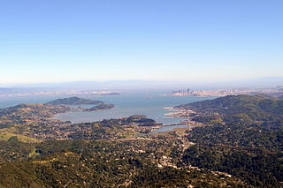
Mission Bay was a bay and the estuary of Mission Creek, on the west shore of San Francisco Bay, between Steamboat Point and Point San Quentin or Potrero Point. It is now mostly filled in and is the location of the Mission Bay neighborhood of San Francisco.
The Port of San Francisco is a semi-independent organization that oversees the port facilities at San Francisco, California, United States. It is run by a five-member commission, appointed by the Mayor and approved by the Board of Supervisors. The Port is responsible for managing the larger waterfront area that extends from the anchorage of the Golden Gate Bridge, along the Marina district, all the way around the north and east shores of the city of San Francisco including Fisherman's Wharf and the Embarcadero, and southward to the city line just beyond Candlestick Point. In 1968, the State of California, via the California State Lands Commission for the State-operated San Francisco Port Authority, transferred its responsibilities for the Harbor of San Francisco waterfront to the City and County of San Francisco / San Francisco Harbor Commission through the Burton Act AB2649. All eligible State port authority employees had the option to become employees of the City and County of San Francisco to maintain consistent operation of the Port of San Francisco.
Richardson Bay is a shallow, ecologically rich arm of San Francisco Bay, managed under a Joint Powers Agency of four northern California cities. The 911-acre (369 ha) Richardson Bay Sanctuary was acquired in the early 1960s by the National Audubon Society. The bay was named for William A. Richardson, early 19th century sea captain and builder in San Francisco. It contains both Strawberry Spit and Aramburu Island.
The Berkeley Marina is the westernmost portion of the city of Berkeley, California, located west of the Eastshore Freeway at the foot of University Avenue on San Francisco Bay. Narrowly speaking, "Berkeley Marina" refers only to the city marina, but in common usage, it applies more generally to the surrounding area.
Point Isabel is a promontory on the eastern shore of San Francisco Bay in the Richmond Annex neighborhood of Richmond, United States.
Swanton is a small community in an unincorporated area of Santa Cruz County on the Pacific coast, situated about 5 miles (8.0 km) north of the town of Davenport, to the east of State Route 1 on Swanton Road. The US Geological Survey designates Swanton as a populated place located at latitude and longitude 37.06417°N 122.22639°W with an elevation of 135 ft (41 m). The ZIP Code is 95017 and the community is inside area code 831.
The Ocean Shore Railroad was a railroad built between San Francisco and Tunitas Glen, and Swanton and Santa Cruz that operated along the Pacific coastline from 1905 until 1921. The route was originally conceived to be a continuous line between San Francisco and Santa Cruz, but the 1906 San Francisco Earthquake, financial difficulties, and the advent of the automobile caused the line to never reach its goals, and remain with a Northern and Southern division.
Steamboat Point a headland marking the northeastern limit of Mission Bay, on San Francisco Bay. It was named for the shipyards that built and repaired steamboats there during the 1850s to the mid 1860s.
Point San Quentin, later known as Potrero Point was the land projecting into San Francisco Bay, and marking the southern extremity of the now filled in Mission Bay in San Francisco, California.
The Swanton Pacific Railroad Society operated an historic one-third scale, 19 in gauge, railroad at Swanton Pacific Ranch in Davenport, California, 15 miles (24 km) north of Santa Cruz, California. The one-mile (1.6 km)-long railroad lies along the Ocean Shore Railroad right-of-way that was to run from San Francisco to Santa Cruz. The scenic trip, through a valley in the coastal mountains, crosses Scott Creek on the Ed Carnegie Bridge, passes a Christmas tree farm, and ends at a wye where passengers observe railroad operations that turn the locomotive.
The Bayshore Cutoff is the rail line between San Francisco and San Bruno along the eastern shore of the San Francisco Peninsula. It was completed by Southern Pacific (SP) in 1907 at a cost of $7 million, and included five tunnels, four of which are still used by Caltrain, the successor to Southern Pacific's Peninsula Commute service. Fill from the five tunnels was used to build the Visitacion or Bayshore Yard, the main SP classification yard near the city of Brisbane. The Del Monte was similarly rerouted over the line at some point in its operational history.
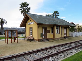
Colma station was a railway station in Colma, California. The depot was served by the Southern Pacific Railroad for most of its functional existence.
Potrero Point is an area in San Francisco, California, east of San Francisco's Potrero Hill neighborhood. Potrero Point was an early San Francisco industrial area. The Point started as small natural land feature that extends into Mission Bay of San Francisco Bay. The Point was enlarged by blasted and cuts on the nearby cliffs. The cut material was removed and used to fill two square miles into the San Francisco bay, making hundreds of acres of flat land. The first factories opened at Potrero Point in the 1860s. Early factories were powder magazine plant, the Pacific Rolling Mill Company and small shipyards. The large Union Iron Works and its shipyards were built at the site, stated in 1849 by Peter Donahue. To power the factories and neighborhood coal and gas-powered electricity works were built, later the site became Pacific Gas and Electric Company (PG&E).
This page is based on this Wikipedia article Text is available under the CC BY-SA 4.0 license; additional terms may apply. Images, videos and audio are available under their respective licenses.