Västra Götaland County is a county or län on the western coast of Sweden.

Sotenäs Municipality is a municipality in Västra Götaland County in western Sweden. Its seat is located in the town of Kungshamn, with around 3,500 inhabitants.

Tanum Municipality is a municipality in Västra Götaland County in western Sweden. Its seat is located in the town of Tanumshede, with 1,600 inhabitants.

Tjörn Municipality is a municipality that covers the island of Tjörn in Västra Götaland County in western Sweden. Its seat is located in the town of Skärhamn.
Gothenburg and Bohus County was a county of Sweden until 1997, when it was merged with Skaraborg County and Älvsborg County to form Västra Götaland County.

Fredriksten is a fortress in the city of Halden in Norway.

Bohus Fortress lies along the old Norwegian–Swedish border in Kungälv, Bohuslän, Sweden, north east from Hisingen where the Göta river splits into two branches. It commands the surrounding area from a cliff 40 m (130 ft) high, with the river forming a natural moat around it.
Gåsö is an island in the Swedish province of Bohuslän, county of Lysekil. Gåsö is situated at the entrance of the Gullmarn fjord and is a part of the Gullmarn nature reserve. The Gåsö archipelago consists partly of two larger islands, Gåsö and Storön, and partly of a large number of smaller islands. The old fishing village on the main island is today only inhabited during summer, when the population reaches approximately 250 people. The Gåsö archipelago has many natural harbours and is a popular destination for boating tourists.
Varekilsnäs is a community located on the island of Orust in Bohuslän, on the Swedish west coast. It is the first village you meet when you enter Orust on road 160 from Tjörn.
The Muscat Gate Museum is a museum located on Al Saidiya Street, Old Muscat, Oman.
CIBE-FM is a First Nations community radio station that operates at 90.1 MHz (FM) in Pakuashipi, Quebec, Canada.
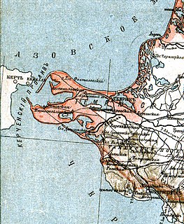
Tuzla was a long narrow peninsula or sandy spit in the eastern part of the Strait of Kerch which extended from Cape Tuzla to the north-west in the direction of the city Kerch for almost 11 km. In 1925 the spit was cut by a storm, forming Tuzla Island. The open-water channel between Tuzla Island and the Russian mainland where the spit had previously existed reached over a km in width.

The Bohuslän Regiment, designation I 17, was a Swedish Army infantry regiment that traces its origins back 1661. It was disbanded in 1992. The regiment's soldiers were originally recruited from the provinces of Bohuslän, and it was later garrisoned there in the town Uddevalla.
Mustametsa is a village in Peipsiääre Parish, Tartu County in Estonia.
Strömsån is a river in Sweden. The river is 30 kilometres (19 mi) long and has a basin with area of 256 square kilometres (99 sq mi). At the mouth of the river lies the city of Strömstad, Bohuslän.

Behrn Arena is an indoor ice hockey arena located in Örebro, Sweden. It is Örebro HK's home arena. The arena opened in 1965 and previously had a capacity of 4,400 spectators, but after a renovation that began in 2010 and finished in September 2011, this number increased to 5,200. The finished renovation of the arena was inaugurated on 28 September 2011.

Byrums raukar are a geological formation of a group of rauks on the western shore in the north of Öland, Sweden near the village of Byrum. The group consists of about 120 limestone stacks, rich in fossils, of up to 4 m (13 ft) high on a 600 m (2,000 ft) stretch of beach. The area is about 3 hectares, is a Natural Monument III and a nature reserve since 1935.

Pilane in Klövdal, Tjörn, Bohuslän, Sweden, is an Iron Age settlement site and grave field, dated to 0-600 AD. The grave field consists of approximately 90 ancient monuments, including stone circles, burial mounds, circular stone grave markers and standing stones. The site is under the care of the Swedish National Heritage Board and the land is leased as sheep pasture.

The Haga dolmen is a megalithic dolmen, dating from the Neolithic era. It is located on the island of Orust in Bohuslän, Västra Götaland County, Sweden, about one kilometre to the east of Tegneby Church. Not far from the dolmen is a second, smaller one, and about 250 metres west of it a large passage grave can be found.