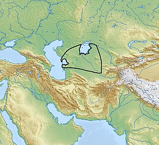
The Syr DaryaSEER-DAR-yə, historically known as the Jaxartes, is a river in Central Asia. The name, which is Persian, literally means Syr Sea or Syr River. It originates in the Tian Shan Mountains in Kyrgyzstan and eastern Uzbekistan and flows for 2,256.25 kilometres (1,401.97 mi) west and north-west through Uzbekistan, Sughd province of Tajikistan, and southern Kazakhstan to the northern remnants of the Aral Sea. It is the northern and eastern of the two main rivers in the endorheic basin of the Aral Sea, the other being the Amu Darya.

A kurgan is a type of tumulus constructed over a grave, often characterized by containing a single human body along with grave vessels, weapons, and horses. Originally in use on the Pontic–Caspian steppe, kurgans spread into much of Central Asia and Eastern, Southeast, Western, and Northern Europe during the third millennium BC.

Jetisu or Semirechye is a historical region in Central Asia corresponding to the southeastern part of modern Kazakhstan.

Turkistan Region, formerly South Kazakhstan Region from 1992 to 2018 and Chimkent Region from 1963 to 1991, is the southernmost region of Kazakhstan. It had a population of 2,088,510 as of 2022; 2,469,367 ; 1,978,339. Its capital is Turkistan, formerly Shymkent until 2018. Other cities in Turkistan include Sayram, Kentau, Arys, Shardara, Zhetisai, Saryagash, and Lenger. This region and Atyrau Region are Kazakhstan's two smallest regions; both are about 117,300 square kilometers in area. Turkistan Region borders the neighboring country of Uzbekistan, as well as three other Kazakhstan regions: Karaganda Region, Kyzylorda Region, and Jambyl Region. The Syr Darya passes through the region, on its way to the Aral Sea. An oil pipeline runs from Turkmenabat, Turkmenistan to Omsk, Russia through South Kazakhstan. Oil, lead and zinc are refined in Shymkent.

Kyzylorda ), formerly known as Kzyl-Orda, Ak-Mechet (Ак-Мечеть), Perovsk (Перовск), Leninsk (Ленинск), and Fort-Perovsky (Форт-Перовский), is a city in south-central Kazakhstan, capital of Kyzylorda Region and former capital of the Kazakh ASSR from 1925 to 1927.

Cathedral Square or Sobornaya Square is the central square of the Moscow Kremlin where all of its streets used to converge in the 15th century.

Kangju was the Chinese name of a kingdom in Central Asia during the first half of the first millennium CE. The name Kangju is now generally regarded as a variant or mutated form of the name Sogdiana. According to contemporaneous Chinese sources, Kangju was the second most powerful state in Transoxiana, after the Yuezhi. Its people, known in Chinese as the Kāng (康), were evidently of Indo-European origins, spoke an Eastern Iranian language, and had a semi-nomadic way of life. The Sogdians may have been the same people as those of Kangju and closely related to the Sakas, or other Iranian groups such as the Asii.

Count Aleksey Sergeyevich Uvarov was a Russian archaeologist often considered to be the founder of the study of the prehistory of Russia.

Kurgan stelae or Balbals are anthropomorphic stone stelae, images cut from stone, installed atop, within or around kurgans, in kurgan cemeteries, or in a double line extending from a kurgan. The stelae are also described as "obelisks" or "statue menhirs".
Yuri Alexeyevich Zuev or Zuyev was a Russian-born Kazakh sinologist and turkologist.

Jankent is a deserted town east of the Aral Sea in modern Kazakhstan. It is known from Arab writings of the 10th century AD as the capital of the steppe empire of Oghuz Turks. Archaeological research has provided information about the appearance of the town and confirmed the date, but also points to earlier origins.

The Leyla-Tepe culture of the South Caucasus belongs to the Chalcolithic era. It got its name from the site in the Agdam District of modern-day Azerbaijan. Its settlements were distributed on the southern slopes of Central Caucasus, from 3800 until 3200 B.C.

The Kelteminar culture was a Neolithic archaeological culture of sedentary fishermen occupying the semi-desert and desert areas of the Karakum and Kyzyl Kum deserts and the deltas of the Amu Darya and Zeravshan rivers in the territories of ancient Kazakhstan, Turkmenistan, and Uzbekistan.

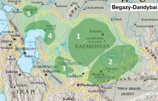
Begazy-Dandybai culture, is a late Bronze Age culture of mixed economy in the territory of ancient central Kazakhstan, Kyrgyzstan, and Uzbekistan, centered at Saryarka region. The Begazy Dandybai Mausolea dates from c. 1350–1150 BCE, and was previously dated between the 12th and 8th centuries BCE, or from 13th to 10th centuries BCE. The culture was discovered, first excavated, and published in the 1930s–1940s by M.P. Gryaznov, who took it for a local version of the Karasuk culture. In 1979 the Begazy-Dandybai culture was described and analyzed in detail in a monograph by A.Kh. Margulan, who systematically reviewed accumulated material and produced description of the archeological culture. The most famous monuments of Begazy-Dandybai culture are Begazy, Dandybai, Aksu Ayuly 2, Akkoytas, and Sangria 1.3, it was named after the first two archeological sites.

Irmen culture is an indigenous Late Bronze Age culture of animal breeders in the steppe and forest steppe area of the Ob river middle course, north of Altai in western Siberia, dated to around the 9th to 8th centuries BCE. Monuments of this advanced bronze-producing culture include numerous settlements and kurgan cemeteries, the culture was named after Irmen kurgan cemetery now flooded by Novosibirsk reservoir. Irmen culture was discovered and described by N.L.Chlenova in 1970.

The Krotov culture was an indigenous culture of animal breeders in the steppe and forest-steppe area of the Western Siberia Altai mountainous area of Russia in the upper Irtysh river basin. The Krotov culture embraces the period from the turn of the 3rd and 2nd millenniums to the 13th to 12th centuries BCE. It is a first (pre-Andronovan) period of developed bronze in the Western Siberia. The Krotov culture is an areal period named for a circle of cultures that include Elunin culture, Krotov culture, Loginov culture and similar cultures with identical or close traits and variations. Krotov culture people engaged in cattle breeding, hunting and fishing. In the territory of the culture were found stone and bronze tools.

The South Turkmenistan Complex Archaeological Expedition (STACE), also called the South Turkmenistan Archaeological Inter-disciplinary Expedition of the Academy of Sciences of the Turkmen Soviet Socialist Republic (YuTAKE) was endorsed by the Turkmenistan Academy of Sciences. It was initially organized by the orientalist Mikhail Evgenievich Masson in 1946. The expedition had several excavations or "Brigades", based on sites and periods, and were spread over many years.
The Chorasmian Archaeological-Ethnographic Expedition of the Academy of Sciences of the USSR explored a large area of Central Asia, where between 1937 and 1991, its members found and recorded almost 1,000 archaeological sites. It was the biggest and longest-lasting of all archaeological expeditions of the Soviet Union.

Baba-Dervish is an ancient settlement in the western part of Qazax District in Azerbaijan. It is located on the south bank of the Aghstafa (river), on the outskirts of Khanlyglar village. Archaeological excavations conducted from 1958 to 1966 revealed three cultural layers here. This settlement is included in the list of archaeological monuments of world significance by the government of Azerbaijan.

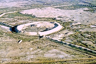
Toprak-Kala, in modern Karakalpakstan, Uzbekistan, was an ancient palace city and the capital of in Chorasmia in the 2nd/3rd century CE, where wall paintings, coins and archives were discovered. Its history covers a period from the 1st to the 5th century CE. It is part of the "Fifty fortresses oasis" in modern-day Uzbekistan.


