Eagledale Park is a 7-acre (28,000m2) park located in the neighborhood of Eagledale on Bainbridge Island in the state of Washington, U.S.. Like several other parks on Bainbridge Island, Eagledale Park comprises land that was once a military installation. Today the park features tennis courts, an off-leash dog park, a picnic shelter, a children's play area, a sand volleyball court and a pottery studio.
In the United States, a state is a constituent political entity, of which there are currently 50. Bound together in a political union, each state holds governmental jurisdiction over a separate and defined geographic territory and shares its sovereignty with the federal government. Due to this shared sovereignty, Americans are citizens both of the federal republic and of the state in which they reside. State citizenship and residency are flexible, and no government approval is required to move between states, except for persons restricted by certain types of court orders. Four states use the term commonwealth rather than state in their full official names.
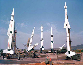
In the 1950s the site was used as part of the Project Nike anti-aircraft missile system.
Project Nike was a U.S. Army project, proposed in May 1945 by Bell Laboratories, to develop a line-of-sight anti-aircraft missile system. The project delivered the United States' first operational anti-aircraft missile system, the Nike Ajax, in 1953. A great number of the technologies and rocket systems used for developing the Nike Ajax were re-used for a number of functions, many of which were given the "Nike" name . The missile's first-stage solid rocket booster became the basis for many types of rocket including the Nike Hercules missile and NASA's Nike Smoke rocket, used for upper-atmosphere research.
The park occupies some of the highest ground on Bainbridge Island. On a clear day, Mount Rainier may be seen from the park.
Mount Rainier, also known as Tahoma or Tacoma, is a large active stratovolcano located 59 miles (95 km) south-southeast of Seattle, in the Mount Rainier National Park. With a summit elevation of 14,411 ft (4,392 m). It is the highest mountain in the U.S. state of Washington, and of the Cascade Range of the Pacific Northwest, it is the most topographically prominent mountain in the contiguous United States and the Cascade Volcanic Arc.
The park is located on Bainbridge Island at 5055 Rose Avenue N.E.
A geographic coordinate system is a coordinate system that enables every location on Earth to be specified by a set of numbers, letters or symbols. The coordinates are often chosen such that one of the numbers represents a vertical position and two or three of the numbers represent a horizontal position; alternatively, a geographic position may be expressed in a combined three-dimensional Cartesian vector. A common choice of coordinates is latitude, longitude and elevation. To specify a location on a plane requires a map projection.
This page is based on this Wikipedia article Text is available under the CC BY-SA 4.0 license; additional terms may apply. Images, videos and audio are available under their respective licenses.
Related Research Articles
Winslow is the name of the downtown area of the city of Bainbridge Island, Washington, and is the original name of the city. It encompasses the area around the main street, Winslow Way, and is made up of approximately 1.5 square miles (3.9 km2) overlooking Eagle Harbor.
Port Madison, sometimes called Port Madison Bay, is a deep water bay located on the west shore of Puget Sound in western Washington. It is bounded on the north by Indianola, on the west by Suquamish, and on the south by Bainbridge Island. Port Madison connects to Bainbridge Island via the Agate Pass Bridge to the southwest. Two small bays open off Port Madison: Miller Bay to the northwest, and another small bay to the south which, confusingly, is also called Port Madison Bay.
Fort Ward Park is a former state park located along Rich Passage on the southern end of Bainbridge Island in Washington. Fort Ward Park is part of the Bainbridge Island Metro Park and Recreation District, on land which the former military base, Fort Ward, was located.
Agate Point is a community of Bainbridge Island, Washington. It is located north of State Highway 305 and is identifiable by many street names containing "Agate". Agate Point is the northernmost point on Bainbridge Island.
Battle Point is a community of Bainbridge Island, Washington, located on the western side of the island. The northern part of the neighborhood extends to Arrow Point. Battle Point also contains the communities of Tolo and Venice.
Creosote was a community of Bainbridge Island, Washington, along Eagle Harbor. The area is directly visible from the downtown Bainbridge Island community of Winslow, and was so named because of the manufacturing and application of creosote at the now-defunct Wyckoff Company plant in the area. The former industrial site is to the north of the community of Bill Point and east of the community of Eagledale at the southern side of the entrance to Eagle Harbor. The site is now the city-owned Pritchard Park and is undergoing Superfund clean-up.
Bill Point is a community of Bainbridge Island, Washington, near Eagle Harbor. It also refers to the sandspit at the southern side of the entrance to Eagle Harbor.
Crystal Springs is a community of Bainbridge Island, Washington. It is located on the southwest side of the island. Although there is not much of a community centre, the area is generally defined as being the western part of Point White, and northward along Crystal Springs Drive Northeast, to Westwood.
Eagledale is a community of Bainbridge Island, Washington. It is located on the eastern part of the island on the south side of Eagle Harbor. Eagledale Park is located within the community.
Fort Ward, named for the former fort of the same name, is a community of Bainbridge Island, Washington. It is located at the very south of the island. Fort Ward is mainly a tangle of residential streets off of Fort Ward Hill Road NE. Fort Ward State Park is a popular recreational destination.
Manitou Beach is an historic beachfront residential neighborhood in Bainbridge Island, Washington. Except for city-owned lots with beach access, there are no parking or facilities for the general public. The city has plans for a small parking lot and boardwalk to improve beach access.
Point Monroe is a unique neighborhood on Bainbridge Island, Washington. Located on the northeastern end of the island, just north of Fay Bainbridge State Park, Point Monroe, also known as "the Sandspit," is a thin strip of land that wraps around a saltwater lagoon. There are over 50 homes on the Sandspit, many of which—because of the thinness of the spit—have two waterfronts - one behind the house, and one in front of it and across the road. Despite the fact that many of the homes are small, often former fishing cabins, current house prices are generally equivalent with larger no-bank waterfront homes elsewhere on the island because of the double waterfronts. Point Monroe is accessible via Point Monroe Drive NE, which is a public road up to the turnaround at its midsection and private shortly after that point. Residents of the Sandspit form a lively and varied community, and celebrate each Fourth of July with their own parade, concluding at the State Park with patriotic songs.
Seabold is a community of Bainbridge Island, Washington. It is located on the northwest corner of the island, on Agate Point. Seabold generally encompasses the south of Agate Point, along NE Seabold Road and NE West Port Madison Road, near State Route 305.
Tolo is a community of Bainbridge Island, Washington. It is located on the western part of the island. The center of Tolo is along Olympus Beach Road NE. Tolo is near to, and sometimes synonymous with, the community of Battle Point. Points of interest include the Grand Forest, Bainbridge Gardens, and nearby Battle Point Park.
Venice is a community of Bainbridge Island, Washington. It is located on Battle Point, around Arrow Point. Venice generally encompasses the area north of Battle Point Park.
West Blakely is a community of Bainbridge Island, Washington. It is located on the south part of the island.
Yeomalt is a community of Bainbridge Island, Washington. It is located on the eastern part of the island, north of Wing Point. Yeomalt is also known as Yeomalt Point.
The Lynwood Theatre is a moviehouse in Bainbridge Island, Kitsap County, Washington. The theatre specializes in showcasing independent and foreign films.
The Bainbridge Island Japanese American Exclusion Memorial is an outdoor exhibit commemorating the internment of Japanese Americans from Bainbridge Island in the state of Washington. It is located on the south shore of Eagle Harbor, opposite the town of Winslow. Administratively, it is a unit of the Minidoka National Historic Site in Idaho.
Pritchard Park is a 50-acre (20 ha) former Superfund environmental cleanup site on the shore of Bainbridge Island's Eagle Harbor in Washington state.