
Mapleton Falls is a national park near the town of Mapleton on the Blackall Range in South East Queensland, Australia, 95 kilometres (59 mi) north of Brisbane. The falls are part of Pencil Creek and drop 120 metres (390 ft).

The South West Coast Path is England's longest waymarked long-distance footpath and a National Trail. It stretches for 630 miles (1,014 km), running from Minehead in Somerset, along the coasts of Devon and Cornwall, to Poole Harbour in Dorset. Because it rises and falls with every river mouth, it is also one of the more challenging trails. The total height climbed has been calculated to be 114,931 ft (35,031 m), almost four times the height of Mount Everest. It has been voted 'Britain's Best Walking route' twice in a row by readers of The Ramblers' Walk magazine, and regularly features in lists of the world's best walks.

The Trans Pennine Trail is a long-distance path running from coast to coast across Northern England on a mixture of surfaced paths, with some short on-road sections, and with gentle gradients. It forms part of European walking route E8 and is part of the National Cycle Network as Route 62.

The National Cycle Network (NCN) was established to encourage cycling and walking throughout the United Kingdom, as well as for the purposes of bicycle touring. It was created by the charity Sustrans who were aided by a £42.5 million National Lottery grant. However Sustrans themselves only own around 2% of the paths on the network, the rest being made of existing public highways and rights of way, and permissive paths negotiated by Sustrans with private landowners.

The Two Moors Way is a long-distance trail mostly in Devon, UK, first established in 1976. It links Dartmoor and Exmoor and has been extended to become a Devon Coast-to-Coast trail.

The Southern Uplands are the southernmost and least populous of mainland Scotland's three major geographic areas. The term is used both to describe the geographical region and to collectively denote the various ranges of hills and mountains within this region. An overwhelmingly rural and agricultural region, the Southern Uplands are partly forested and contain many areas of open moorland - the hill names in the area are congruent with these characteristics.

Hadrian's Wall Path is a long-distance footpath in the north of England, which became the 15th National Trail in 2003. It runs for 84 miles (135 km), from Wallsend on the east coast of England to Bowness-on-Solway on the west coast. For most of its length it is close to the remains of Hadrian's Wall, the defensive wall built by the Romans on the northern border of their empire. This is now recognised as part of the "Frontiers of the Roman Empire" World Heritage Site.
The Vanguard Way is a long-distance walk of 66.2 mi (106.5 km) from East Croydon station in outer London, travelling from the north, to Newhaven, on the south coast of England. It passes through the counties of Surrey, Kent and East Sussex, between Croydon and Newhaven, East Sussex. It connects the London suburbs to the south coast, via the North Downs, Ashdown Forest, South Downs National Park and the Cuckmere valley.
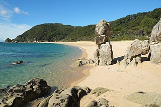
The Abel Tasman Coast Track is a 60 kilometres (37 mi) long walking track within the Abel Tasman National Park in New Zealand. It extends from Mārahau in the south to Wainui in the north, with many side tracks. It is one of two main tracks through the park, the other being the Abel Tasman Inland Track, which stretches for 38 km between Tinline Bay and Torrent Bay off the main coastal track. The coastal track is well sheltered, and with mild weather in all seasons, it is accessible and open throughout the year.
The Anglesey Coastal Path is a 200-kilometre (124 mi) long-distance footpath around the island of Anglesey in North Wales. The route is part of the Wales Coast Path.
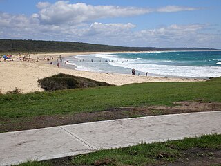
Dalmeny is a town on the south coast of New South Wales, Australia, approximately seven kilometres north of Narooma. At the 2021 census, Dalmeny had a population of 2,194.
The Celtic Way is a long-distance walk from West Wales, through South Wales and into Wessex and the West of England in the United Kingdom. The route is 725-mile-long (1,167 km) and visits more than one hundred pre-historic sites through its route.
The Ramblers Association, branded simply as the Ramblers, is Great Britain's walking charity. The Ramblers is also a membership organisation with around 100,000 members and a network of volunteers who maintain and protect the path network. The organisation was founded in 1935 and campaigns to keep the British countryside open to all.

Gloucester River, a perennial river and major tributary of the Manning River catchment, is located in the Mid North Coast hinterland New South Wales, Australia.

A long-distance trail is a longer recreational trail mainly through rural areas used for hiking, backpacking, cycling, horse riding or cross-country skiing. They exist on all continents except Antarctica.

Newland Head Conservation Park is a protected area located in South Australia within the locality of Waitpinga on the southern coast of the Fleurieu Peninsula 91 km south of the centre of Adelaide, and 7 km southwest of Victor Harbor. Its name is taken from Newland Head that feature prominently at the eastern boundary of the park. The conservation park is classified as an IUCN Category III protected area.
National Cycle Network (NCN) Route 71 is a Sustrans National Route that runs from Whitehaven and Workington on the Cumbrian coast to Kirby Knowle in North Yorkshire to join NCN Route 65. The route is fully open and signed in both directions.