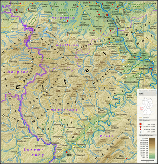
The Eifel is a low mountain range in western Germany and eastern Belgium. It occupies parts of southwestern North Rhine-Westphalia, northwestern Rhineland-Palatinate and the southern area of the German-speaking Community of Belgium.
The Eifelkreis Bitburg-Prüm is a district in Rhineland-Palatinate, Germany. It is bounded by Luxembourg, Belgium and the districts of Euskirchen, Vulkaneifel, Bernkastel-Wittlich and Trier-Saarburg.

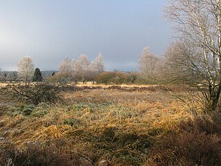
The High Fens, which were declared a nature reserve in 1957, are an upland area, a plateau region in the province of Liège, in the east of Belgium and adjoining parts of Germany, between the Ardennes and the Eifel highlands. The High Fens are the largest nature reserve or park in Belgium, with an area of 4,501.2 hectares ; it lies within the German-Belgian natural park Hohes Venn-Eifel, in the Ardennes. Its highest point, at 694 metres (2,277 ft) above sea level, is the Signal de Botrange near Eupen, and also the highest point in Belgium. A tower 6 metres (20 ft) high was built here that reaches 700 metres (2,297 ft) above sea level. The reserve is a rich ecological endowment of Belgium covered with alpine sphagnum raised bogs both on the plateau and in the valley basin; the bogs, which are over 10,000 years old, with their unique subalpine flora, fauna and microclimate, are key to the conservation work of the park.

The Hoher List is a stratovolcano, 549.1 m above sea level (NN), near the town of Daun in the Eifel region. The hill is in the county of Vulkaneifel in the German state of Rhineland-Palatinate.

Dahlem is a municipality in the district of Euskirchen. It has the lowest population density and population of all municipalities of in the state of North Rhine-Westphalia, Germany. It is located in the Eifel hills, approx. 35 km south-west of Euskirchen. The small medieval town Kronenburg is part of the municipality.
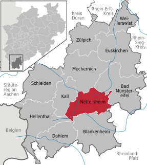
Nettersheim is a municipality in the district of Euskirchen in the state of North Rhine-Westphalia, Germany. It is located in the Eifel hills, approx. 20 km south-west of Euskirchen. The rivers Erft and Urft have their source in the municipality.
Bleialf is a municipality in the district of Bitburg-Prüm, in Rhineland-Palatinate, western Germany.
Utscheid is a municipality in the district of Bitburg-Prüm, in Rhineland-Palatinate, western Germany.

The West Eifel refers to that part of the Eifel mountains in Germany that is centred on the town of Prüm and reaches as far as the border with Belgium and Luxembourg. It is not geographically precisely defined however, overlapping by about 60% with the Schnee Eifel), whilst geologically its northern half is part of the Vulkaneifel and its southern half part of the South Eifel.
The North Eifel, the northern part of the Eifel, a low mountain range in Germany and East Belgium, comprises the following six sub-regions:
The South Eifel refers to that part of the Eifel mountain region around the Bitburg-Prüm district in the German state of Rhineland-Palatinate.
The Schnee Eifel is a heavily wooded landscape in Germany's Central Uplands, up to 699.1 m above sea level (NHN), that forms part of the western Eifel in the area of the German-Belgian border. The name may have been derived in the 19th century from the Schneifel chain of hills which had nothing to do with snow (Schnee), but with the name for a forest swathe (Schneise).
The Rur Eifel lies in the district of Düren in the German state of North Rhine-Westphalia, and is a local recreation area from the regions of Cologne, Aachen, Düsseldorf, Krefeld, Mönchengladbach and Bonn. Its name comes from the river Rur and the Eifel Mountains.
The German-Belgian High Fens – Eifel Nature Park, often called the North Eifel Nature Park, is a cross-border nature park with elements in the German federal states of North Rhine-Westphalia and Rhineland-Palatinate as well as the Belgian province of Liège. It has a total area of 2,485 km2 (959 sq mi).
The Zitter Forest is located in the Eifel region in the German district of Euskirchen and in the Belgian province of Liège (Wallonia). Its highest point is 692 m above sea level (NN).
The Voreifel is the name of a settlement area in the southern part of the German state of North Rhine-Westphalia. It is a term that grew out of the local speech.
The Eifel National Park is the 14th national park in Germany and the first in North Rhine-Westphalia.

Oliver Krischer is a German Green politician and member of the German Bundestag.

The Volcano Park in Mayen-Koblenz is a geopark in the rural district of Mayen-Koblenz in the eastern Vulkan Eifel, Germany. It was founded in 1996 and wraps around the Laacher See. Together with the Volcano Park, Brohltal/Laacher See and the Vulkan Eifel Nature and Geo-Park, it forms part of the national Eifel Volcano Land Geo-Park. The three parks are connected by the 280-kilometre-long German Volcano Route.

The Volcanic Eifel Nature Park lies in the counties of Bernkastel-Wittlich, Cochem-Zell and Vulkaneifel in the German state of Rhineland-Palatinate. The nature park, which is in the Eifel mountains, and which is also a geopark, was inaugurated on 31 May 2010 and has an area of 1,068.24 km².> Its sponsor is the Natur- und Geopark Vulkaneifel GmbH.