El Carrizal Dam

Last updated

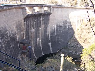
The El Carrizal Dam (in Spanish, Embalse El Carrizal) is a dam on the upper-middle course of the Tunuyán River, in the center-north of the province of Mendoza, Argentina upstream from the city of Rivadavia. Its reservoir measures about 15 by 5 kilometres (9.3 mi × 3.1 mi), and its maximum water level stands at 785.5 metres (2,577 ft) above the sea, covering an area of 31.47 square kilometres (12.15 sq mi). It has a maximum volume of 327 million cubic metres (11.5×10^9 cu ft).

Dam A barrier that stops or restricts the flow of surface or underground streams

A dam is a barrier that stops or restricts the flow of water or underground streams. Reservoirs created by dams not only suppress floods but also provide water for activities such as irrigation, human consumption, industrial use, aquaculture, and navigability. Hydropower is often used in conjunction with dams to generate electricity. A dam can also be used to collect water or for storage of water which can be evenly distributed between locations. Dams generally serve the primary purpose of retaining water, while other structures such as floodgates or levees are used to manage or prevent water flow into specific land regions. The earliest known dam is the Jawa Dam in Jordan, dating to 3,000 BC.

The Tunuyán River is a river in the Argentine province of Mendoza. It is born in Mount Tupungato, in the Andes range, and flows initially to the northeast, passing by the city of Tunuyán. It is then dammed by the El Carrizal Dam, after which it turns east-southeast passing near the cities of Rivadavia, Santa Rosa and La Paz. Finally, it branches into the Tunuyán Nuevo (north) and Tunuyán Viejo (south), and empties into the Desaguadero River.

Provinces of Argentina

Argentina is subdivided into twenty-three provinces and one autonomous city, Buenos Aires, which is the federal capital of the nation as decided by Congress. The provinces and the capital have their own constitutions, but exist under a federal system.

Contents

The dam is used to regulate the flow of the Tunuyán River, which comes from glacial sources in the Andes, and to irrigate the otherwise arid region. The reservoir is a tourist attraction and is employed for fishing, windsurfing, sailing, etc., while its shores feature camping sites and other lodging facilities.

Glacier Persistent body of ice that is moving under its own weight

A glacier is a persistent body of dense ice that is constantly moving under its own weight; it forms where the accumulation of snow exceeds its ablation over many years, often centuries. Glaciers slowly deform and flow due to stresses induced by their weight, creating crevasses, seracs, and other distinguishing features. They also abrade rock and debris from their substrate to create landforms such as cirques and moraines. Glaciers form only on land and are distinct from the much thinner sea ice and lake ice that form on the surface of bodies of water.

Andes mountain range running along the tu mamide of South America

The Andes or Andean Mountains are the longest continental mountain range in the world, forming a continuous highland along the western edge of South America. This range is about 7,000 km (4,300 mi) long, about 200 to 700 km wide, and of an average height of about 4,000 m (13,000 ft). The Andes extend from north to south through seven South American countries: Venezuela, Colombia, Ecuador, Peru, Bolivia, Chile and Argentina.

Irrigation artificial application of water to the land

Irrigation is the application of controlled amounts of water to plants at needed intervals. Irrigation helps to grow agricultural crops, maintain landscapes, and revegetate disturbed soils in dry areas and during periods of less than average rainfall. Irrigation also has other uses in crop production, including frost protection, suppressing weed growth in grain fields and preventing soil consolidation. In contrast, agriculture that relies only on direct rainfall is referred to as rain-fed or dry land farming.

The waters of the dam feed a hydroelectric power station, which was built in 1971 and has an installed power generation capacity of 17 megawatts (23,000 hp).

Hydroelectricity electricity generated by hydropower

Hydroelectricity is electricity produced from hydropower. In 2015, hydropower generated 16.6% of the world's total electricity and 70% of all renewable electricity, and was expected to increase about 3.1% each year for the next 25 years.

Power station facility generating electric power

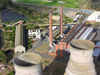
A power station, also referred to as a power plant or powerhouse and sometimes generating station or generating plant, is an industrial facility for the generation of electric power. Most power stations contain one or more generators, a rotating machine that converts mechanical power into electrical power. The relative motion between a magnetic field and a conductor creates an electrical current. The energy source harnessed to turn the generator varies widely. Most power stations in the world burn fossil fuels such as coal, oil, and natural gas to generate electricity. Others use nuclear power, but there is an increasing use of cleaner renewable sources such as solar, wind, wave and hydroelectric.

Notes

    Related Research Articles

    Gandhi Sagar Dam dam

    The Gandhi Sagar Dam is one of the four major dams built on India's Chambal River. The dam is located in the Mandsaur, Neemuch districts of the state of Madhya Pradesh. It is a masonry gravity dam, standing 62.17 metres (204.0 ft) high, with a gross storage capacity of 7.322 billion cubic metres from a catchment area of 22,584 km2 (8,720 sq mi). The dam's foundation stone was laid by Prime Minister of India Pandit Jawaharlal Nehru on 7 March 1954, and construction of the main dam was done by leading contractor Dwarka Das Agrawal & Associates and was completed in 1960. Additional dam structures were completed downstream in the 1970s.

    Blowering Dam hydroelectric power station on the Tumut River in New South Wales, Australia

    The Blowering Dam is a major ungated rock fill with clay core embankment dam with concrete chute spillway across the Tumut River upstream of Tumut in the Snowy Mountains region of New South Wales, Australia. The dam's purpose includes flood mitigation, hydro-power, irrigation, water supply and conservation. The dam is part of the Snowy Mountains Scheme, a vast hydroelectricity and irrigation complex constructed in south-east Australia between 1949 and 1974 and now run by Snowy Hydro. The impounded reservoir is called Blowering Reservoir.

    Salto Grande Dam hydroelectric dam in Argentina and Uruguay

    The Salto Grande Dam is a large hydroelectric dam on the Uruguay River, located between Concordia, Argentina, and Salto, Uruguay; thus is shared between the two countries.

    Los Molinos Dam dam in Argentina

    The Los Molinos Dam is a dam over the course of the Los Molinos River in the center-west of the province of Córdoba, Argentina, about 769 metres (2,523 ft) above mean sea level.

    Quebrada de Ullúm Dam dam in Argentina

    The Quebrada de Ullúm Dam, or simply Ullúm Dam, is an embankment dam on the San Juan River, just west of San Juan in Ullúm Department of the Province of San Juan, Argentina. It is located at the gorge of the Quebrada de Ullum, 18 kilometres (11 mi) upstream from the provincial capital San Juan, and creates a reservoir with an area of 32 square kilometres (12 sq mi), a volume of 440 million cubic metres, and average and maximum depths of 15 and 40 metres, respectively. The reservoir feeds a hydroelectric power station with an installed power capacity of 45 megawatts (60,000 hp).

    Rivadavia, Mendoza City in Mendoza, Argentina

    Rivadavia is a city in the center-north of the province of Mendoza, Argentina. It has 52,567 inhabitants as per the 2001 census [INDEC], and is the head town of the Rivadavia Department. The city lies on the north bank of the Tunuyán River, downstream from the reservoir of the El Carrizal Dam, which is one of its tourist attractions.

    Alicurá Dam lake in Argentina

    The Alicurá Dam is the first of five dams on the Limay River in northwestern Argentine Patagonia, about 100 kilometres (62 mi) from the city of San Carlos de Bariloche and 705 metres (2,313 ft) above mean sea level. It was inaugurated in 1985.

    El Chocón Dam dam

    The El Chocón Dam is the fourth of the five dams on the Limay River in the northwestern Argentine Patagonia, at 381 metres (1,250 ft) above mean sea level. El Chocón is on the Limay River at about 80 km (50 mi) upstream of its confluence with the Neuquén River.

    The Arroyito Dam is the fifth of five dams on the Limay River in northwestern Argentine Patagonia, at 315 metres (1,033 ft) above mean sea level. It was inaugurated in 1979.

    Rana Pratap Sagar Dam dam in India

    The Ranapratap Sagar Dam is a gravity masonry dam of 53.8 metres (177 ft) height built on the Chambal River at Rawatbhata in Rajasthan in India. It is part of integrated scheme of a cascade development of the river involving four projects starting with the Gandhi Sagar Dam in the upstream reach in Madhya Pradesh and the Jawahar Sagar Dam on the downstream with a terminal structure of the Kota Barrage in Rajasthan for irrigation.

    Lake Qaraoun lake in Lebanon

    Lake Qaraoun is an artificial lake or reservoir located in the southern region of the Beqaa Valley, Lebanon. It was created near Qaraoun village in 1959 by building a 61-metre-high (200 ft) concrete-faced rockfill dam in the middle reaches of the Litani River. The reservoir has been used for hydropower generation, domestic water supply, and for irrigation of 27,500 hectares.

    Pindari Dam

    Pindari Dam is a minor concrete faced rockfill embankment dam with an ungated uncontrolled rock cut with concrete sill spillway across the Severn River located upstream of the town of Ashford, in the North West Slopes region of New South Wales, Australia. The dam's purpose includes flood mitigation, hydro-power, irrigation, water supply and conservation. The impounded reservoir is called Lake Pindari.

    Xingó Dam

    The Xingó Dam is a concrete face rock-fill dam on the São Francisco River on the border of Alagoas and Sergipe, near Piranhas, Brazil. The dam was built for navigation, water supply and hydroelectric power generation as it supports a 3,162 megawatts (4,240,000 hp) power station. It was constructed between 1987 and 1994 and the last of its generators was commissioned in 1997. In Portuguese, the dam is called the Usina Hidrelétrica de Xingó.

    Salto Osório Hydroelectric Power Plant

    The Salto Osório Hydroelectric Power Plant is a dam and hydroelectric power plant on the Iguazu River near Osório in Paraná, Brazil. It is the second dam upstream of the Iguazu Falls and was completed in 1979. The power station has a 1,078 MW capacity and is supplied with water by a rock-fill embankment dam.

    Aras Dam

    The Aras Dam is an embankment dam on the Aras River along the border of Iran and Azerbaijan. It is located downstream of Poldasht in West Azerbaijan Province, Iran and Nakhchivan City in Nakhchivan Autonomous Republic, Azerbaijan. The primary purpose of the dam is hydroelectric power production and water supply.

    La Esmeralda Dam dam in Colombia

    La Esmeralda Dam is an embankment dam on the Batá River northwest of Santa María in Boyacá Department, Neira Province, Colombia. The primary purpose of the dam is hydroelectric power production and it is part of the Chivor Hydroelectric Project. Water from the Batá is diverted by the dam to a power station that discharges to the Lengupá River. The power station supplies 8% of Colombia's power demand.

    El Quimbo Dam

    The El Quimbo Dam is a concrete faced rock-fill dam (CFRD) and hydroelectric power project under development in the Huila Department of southwestern-central Colombia, approximately 69 kilometres (43 mi) south of the city of Neiva, on the Magdalena River. It is located about 1,300 metres (4,300 ft) upstream from the confluence of the Páez River with the Magdalena River. Its works were officially opened on February 25, 2011 in the presence of President Juan Manuel Santos. It is one of the largest infrastructure projects in the country. The project is planned to be completed over a period of 4 years, in 2015.

    Daecheong Dam dam in South Korea

    The Daecheong Dam is a combination concrete gravity and embankment dam on the Geum River, 16 km (10 mi) north of Daejeon in South Korea. The multi-purpose dam provides benefits of flood control, water supply and hydroelectric power generation. Construction on the dam began in 1975 and was formally commissioned on 1 December 1980. The 72 m (236 ft) high rock-fill dam has a central clay core and has created a reservoir with storage of 1,490,000,000 m3 (1,207,963 acre⋅ft).

    Rydal Dam

    Rydal Dam is a minor ungated homogeneous earthfill embankment dam with a fuse plug uncontrolled open channel spillway across an off stream storage, located near Rydal in the Central Tablelands region of New South Wales, Australia. The dam's purpose is to provide water storage for Delta power stations at Wallerawang and Mount Piper. The impounded reservoir is also called the Rydal Dam.

    References

    Coordinates: 33°18′0″S68°43′15″W / 33.30000°S 68.72083°W / -33.30000; -68.72083

    Geographic coordinate system Coordinate system

    A geographic coordinate system is a coordinate system that enables every location on Earth to be specified by a set of numbers, letters or symbols. The coordinates are often chosen such that one of the numbers represents a vertical position and two or three of the numbers represent a horizontal position; alternatively, a geographic position may be expressed in a combined three-dimensional Cartesian vector. A common choice of coordinates is latitude, longitude and elevation. To specify a location on a plane requires a map projection.