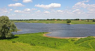
The Elbe is one of the major rivers of Central Europe. It rises in the Giant Mountains of the northern Czech Republic before traversing much of Bohemia, then Germany and flowing into the North Sea at Cuxhaven, 110 kilometres northwest of Hamburg. Its total length is 1,094 km (680 mi).

The Aller is a 215-kilometre-long (134 mi) river in the states of Saxony-Anhalt and Lower Saxony in Germany. It is a right-hand, and hence eastern, tributary of the Weser and is also its largest tributary. Its last 117 kilometres (73 mi) form the Lower Aller federal waterway. The Aller was extensively straightened, widened and, in places, dyked, during the 1960s to provide flood control of the river. In a 20-kilometre-long (12 mi) section near Gifhorn, the river meanders in its natural river bed.

The Last Glacial Period (LGP), also known as the Last glacial cycle, occurred from the end of the Last Interglacial to the beginning of the Holocene, c. 115,000 – c. 11,700 years ago, and thus corresponds to most of the timespan of the Late Pleistocene.

A jökulhlaup is a type of glacial outburst flood. It is an Icelandic term that has been adopted in glaciological terminology in many languages. It originally referred to the well-known subglacial outburst floods from Vatnajökull, Iceland, which are triggered by geothermal heating and occasionally by a volcanic subglacial eruption, but it is now used to describe any large and abrupt release of water from a subglacial or proglacial lake/reservoir.

A tunnel valley is a U-shaped valley originally cut under the glacial ice near the margin of continental ice sheets such as that now covering Antarctica and formerly covering portions of all continents during past glacial ages. They can be as long as 100 km (62 mi), 4 km (2.5 mi) wide, and 400 m (1,300 ft) deep.

Salmons Brook is a minor tributary of the River Lea, located in the London Borough of Enfield.

The Saale glaciation or Saale Glaciation, sometimes referred to as the Saalian glaciation, Saale cold period, Saale complex (Saale-Komplex) or Saale glacial stage, covers the middle of the three large glaciations in Northern Europe and the northern parts of Eastern Europe, Central Europe and Western Europe by the Scandinavian Inland Ice Sheet. It follows the Holstein interglacial and precedes the Eemian interglacial, spanning from around 400,000 years ago to 130,000 years ago. The Saalian covers multiple glacial cycles punctuated by interglacial periods. In its latter part it is coeval with the global Penultimate Glacial Period.

The North German Plain or Northern Lowland is one of the major geographical regions of Germany. It is the German part of the North European Plain. The region is bounded by the coasts of the North Sea and the Baltic Sea to the north, Germany's Central Uplands to the south, by the Netherlands to the west and Poland to the east.

The Weichselian glaciation is the regional name for the Last Glacial Period in the northern parts of Europe. In the Alpine region it corresponds to the Würm glaciation. It was characterized by a large ice sheet that spread out from the Scandinavian Mountains and extended as far as the east coast of Schleswig-Holstein, northern Poland and Northwest Russia. This glaciation is also known as the Weichselian ice age, Vistulian glaciation, Weichsel or, less commonly, the Weichsel glaciation, Weichselian cold period (Weichsel-Kaltzeit), Weichselian glacial (Weichsel-Glazial), Weichselian Stage or, rarely, the Weichselian complex (Weichsel-Komplex).

The Drawehn is a partly wooded and partly agricultural region of hills in the northeastern part of the German state of Lower Saxony, lying between the districts of Lüneburg and Uelzen in the west and Lüchow-Dannenberg in the east.
The Cloppenburg Geest is a geest region near the town of Cloppenburg in North Germany and the centre of the Saalian glaciation Upper Pleistocene terrain of the Ems-Hunte Geest region. The meltwater sands (Schmelzwassersande) of the advancing ice sheet covered the old terrain with outwash sands (Vorschüttsande). Woldstedt spoke about underlying sands that, in the "Cloppenburg-Bassum Geest", belonged to the Elster glaciation. A covering of boulder clay was deposited over the outwash sands during the Saale glaciation, or more precisely the Drenthe stage.
The Damme Hills are a high, wooded ridge, up to 146 m above sea level (NN), in the Oldenburg Münsterland in the southern part of the district of Vechta, in western Lower Saxony, Germany.
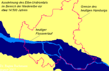
An urstromtal is a type of broad glacial valley, for example, in northern Central Europe, that appeared during the ice ages, or individual glacial periods of an ice age, at the edge of the Scandinavian ice sheet and was formed by meltwaters that flowed more or less parallel to the ice margin. Urstromtäler are an element of the glacial series. The term is German and means "ancient stream valley". Although often translated as "glacial valley", it should not be confused with a valley carved out by a glacier. More accurately some sources call them "meltwater valleys" or "ice-marginal valleys".
The glacial series refers to a particular sequence of landforms in Central Europe that were formed during the Pleistocene glaciation beneath the ice sheets, along their margins and on their forelands during each glacial advance.
The Wendland is a region in Germany on the borders of the present states of Brandenburg, Mecklenburg-Western Pomerania, Lower Saxony and Saxony-Anhalt. Its heart is the Hanoverian Wendland in the county of Lüchow-Dannenberg in Lower Saxony.
The Upper Lusatian Heath and Pond Landscape is a natural region in Saxony. It runs from a line between Wittichenau and Kamenz for roughly 60 kilometres in an east-west direction as far as the River Neisse. Its width between the bordering natural regions of the Upper Lusatian Gefilde and Eastern Upper Lusatia to the south and the Muskau Heath and Upper Lusatian Mining Region to the north is between 15 and 20 kilometres.

A Ländchen is the German name given to several Ice Age plateaux in the Havelland region, which climb to over 70 metres above the formerly marshy urstromtal levels of the Havelland Luch and the Rhinluch. The difference between these Ländchen and the surrounding countryside is even more marked because of the different land uses to which they are put. Extensive pastures in the lowlands contrast with the arable fields and woods on the low hills. Geologically they are largely complete formations of ground moraine from the Saale and Weichselian glaciations that, in places, are covered by gently rolling end moraines.

Teltow is both a geological plateau and also a historical region in the German states of Brandenburg and Berlin. As an historical region, the Teltow was one of the eight territories out of which the March of Brandenburg was formed in the 12th and 13th centuries. As a result of the Teltow War (1239–1245) the question of territorial lordship of the newly created heart of the expanding march was finally decided here. Between 1835 and 1952 there was also a county, Teltow district; in addition a town immediately south of Berlin, in the present-day county of Potsdam-Mittelmark, bears the name Teltow.
The geology of the Baltic Sea is characterized by having areas located both at the Baltic Shield of the East European Craton and in the Danish-North German-Polish Caledonides. Historical geologists make a distinction between the current Baltic Sea depression, formed in the Cenozoic era, and the much older sedimentary basins whose sediments are preserved in the zone. Although glacial erosion has contributed to shape the present depression, the Baltic trough is largely a depression of tectonic origin that existed long before the Quaternary glaciation.
The Central Brandenburg Plateaux and Lowlands form a natural region in the German state of Brandenburg and in parts of southwest Berlin and the east of Saxony-Anhalt. They are major unit group 81 in the system of natural regions of Germany and part of the East German Plateaux and Heathlands. The Brandenburg portion of the Central Brandenburg Plateaux and Lowlands is largely coincident with the natural region designated as the Central March in the structural atlas of the state of Brandenburg.