This page is based on this
Wikipedia article Text is available under the
CC BY-SA 4.0 license; additional terms may apply.
Images, videos and audio are available under their respective licenses.
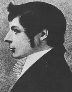
John Joseph William Molesworth Oxley
was an explorer and surveyor of Australia in the early period of British colonisation. He served as Surveyor General of New South Wales and is perhaps best known for his two expeditions into the interior of New South Wales and his discoveries of the Tweed River and the Brisbane River in what is now the state of Queensland.
The Division of Blair is an Australian Electoral Division in Queensland. The division was created in 1998 and is named after Harold Blair, an Aboriginal singer and civil rights campaigner. The Division is based on Ipswich, and extends from rural and exurban areas west of Brisbane to the Scenic Rim and Lockyer Valley regions.

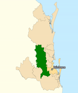
The Division of Griffith is an electoral division for the Australian House of Representatives. The division covers the inner southern suburbs of Brisbane, Queensland.

The Division of Moreton is an Australian Electoral Division in Queensland. The division was one of the original 65 divisions contested at the first federal election. It is named after Moreton Bay, and originally stretched from southern Brisbane all the way to the Gold Coast. While successive redistributions have left the seat completely landlocked, it has nonetheless retained the name of Moreton, mainly because the Australian Electoral Commission's guidelines on electoral redistributions require it to preserve the names of original electorates where possible.
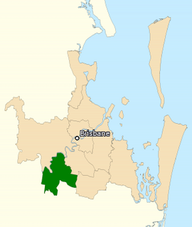
The Division of Oxley was an Australian Electoral Division in the state of Queensland. It was located in the inner southern suburbs of Brisbane, and originally included the suburbs of South Brisbane, Woolloongabba and Coorparoo. By the time it was abolished in 1934, it had been redistributed to cover suburbs such as Bulimba and Murarrie.
This is a list of current and former electoral divisions for the Legislative Assembly of Queensland, the state legislature for Queensland, Australia.

Mount Ommaney is an electoral district of the Legislative Assembly in the Australian state of Queensland. It was created with the 1992 redistribution.
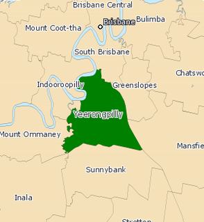
Yeerongpilly was a Legislative Assembly electorate the state of Queensland. Named for the suburb with the same name, the electorate was renamed before the 2001 elections from the previous name of Yeronga. In 2017, it was abolished and replaced by the electoral district of Miller.
A State Electoral District is an electorate within the Lower House or Legislative Assembly of Australian states and territories. Most state electoral districts send a single member to a state or territory's parliament using the preferential method of voting. The area of a state electoral district is dependent upon the Electoral Acts in the various states and vary in area between them. At present, there are 409 state electoral districts in Australia.
Hastings and Macleay was an electoral district of the Legislative Assembly in the Australian state of New South Wales from 1894 to 1920. It was created with the division of the two-member electorate of Hastings and Manning. In 1920 proportional representation was introduced and Hastings and Macleay was absorbed into the new four-member district of Oxley. The electorate was named after the Hastings and Macleay Rivers, the alluvial valleys of which contained most of its population.
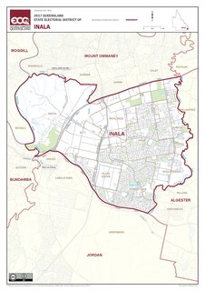
The electoral district of Inala is an electoral district of the Legislative Assembly of Queensland in south-west Brisbane. It includes the suburbs of Inala, Ellen Grove, Forest Lake, Doolandella, Durack, Wacol, Richlands, and parts of Oxley. It borders the electoral districts of Mount Ommaney, Miller, Algester, Jordan, Bundamba, and Moggill.
Sherwood was an electoral district of the Legislative Assembly in the Australian state of Queensland from 1950 to 1992.
Augustus Cecil Elphinstone (1874–1964) was an Australian businessman and politician. He served in the Legislative Assembly of Queensland for the electoral district of Oxley (Queensland) from 1918 until 1929.
This is a list of electoral results for the Electoral district of Oxley in New South Wales state elections.

James John Cadell, was a politician in Queensland, Australia. He was a Member of the Queensland Legislative Assembly for the electoral district of Burnett from 11 July 1891 - 28 March 1896.
John Desmond Herbert was an Australian politician, who was the Liberal Party member for the electoral district of Sherwood in the Queensland Legislative Assembly from 1956 to 1978.