Cobham is a large village in the Borough of Elmbridge in Surrey, England, centred 17 miles (27 km) south-west of London and 10 miles (16 km) northeast of Guildford on the River Mole. It has a commercial/services High Street, a significant number of primary and private schools and the Painshill landscape park.

Oatlands is a village in the north of the English county of Surrey on low, verdant ridges partially overlooking the River Thames. Oatlands acquired its name from the Royal Tudor and Stuart Oatlands Palace, which was built for Henry VIII to the north of Weybridge town centre. Before acquiring its first place of worship it was part of Walton on Thames, and shortly after thereby becoming a village did not qualify for post town status and instead its post town became Weybridge. The towns it adjoins have their centres 1 mile (1.6 km) away. Oatlands has a park, parade of shops, one pub, one Working Men's Club, and three schools.

Weybridge is a town in the Borough of Elmbridge in Surrey, England, around 17 mi (27 km) southwest of central London. The settlement is recorded as Waigebrugge and Weibrugge in the 7th century and the name derives from a crossing point of the River Wey, which flows into the River Thames to the north of the town centre. The earliest evidence of human activity is from the Bronze Age. During the Anglo-Saxon and medieval periods, Weybridge was held by Chertsey Abbey.

Esher is a town in Surrey, England, to the east of the River Mole.

Elmbridge is a local government district with borough status in Surrey, England. Its principal towns and villages are Esher, Cobham, Walton-on-Thames, Weybridge and Molesey. It directly borders the London Borough of Richmond upon Thames and the London Royal Borough of Kingston upon Thames. Some areas of the borough form a continuation of the Greater London Built-up Area, formerly falling into the Metropolitan Police District.

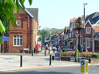
Walton-on-Thames, locally known as Walton, is a market town on the south bank of the Thames in the Elmbridge borough of Surrey, England. Walton forms part of the Greater London built-up area, within the KT postcode and is served by a wide range of transport links. According to the 2011 Census, the town has a total population of 22,834. The town itself consists mostly of affluent suburban streets, with a historic town centre of Celtic origin. It is one of the largest towns in the Elmbridge borough, alongside Weybridge.

Thames Ditton is a suburban village on the River Thames, in the Elmbridge borough of Surrey, England. Apart from a large inhabited island in the river, it lies on the southern bank, centred 12.2 miles (19.6 km) southwest of Charing Cross in central London. Thames Ditton is just outside Greater London but within the Greater London Urban Area as defined by the Office for National Statistics. Its clustered village centre and shopping area on a winding High Street is surrounded by housing, schools and sports areas. Its riverside faces the Thames Path and Hampton Court Palace Gardens and golf course in the London Borough of Richmond upon Thames. Its most commercial area is spread throughout its conservation area and contains restaurants, cafés, shops and businesses.

Stoke d'Abernon is a village and former civil parish in the borough of Elmbridge in Surrey, England. It is on the right bank of the River Mole contiguously south of Cobham, a larger settlement which is a post town and is east-southeast of Oxshott a large village founded in the 19th century from the higher, sandy forested part of its formerly expansive area. It shares a railway station with Cobham and is inside the M25 motorway. Cobham Training Centre, the training ground of Chelsea F.C., is within its traditional boundaries.

Thames Ditton railway station serves Thames Ditton in the Elmbridge district of Surrey, England. It is the only intermediate station on the Hampton Court branch line, 14 miles 1 chain (22.6 km) down the line from London Waterloo.

Hampton Court railway station is a suburban terminus station at East Molesey, in the Borough of Elmbridge in the county of Surrey, 100 yards short of Hampton Court Bridge, the midpoint of which is a boundary of Greater London. The station is 14 miles 76 chains (24.1 km) down the line from London Waterloo.

Walton-on-Thames railway station is at the southern edge of the town of Walton-on-Thames in Surrey, England and borders Burwood Park, Hersham. It is 17 miles 6 chains (27.5 km) from London Waterloo and is situated between Hersham and Weybridge.

Claygate is an affluent suburban village in Surrey, England, 14 miles southwest of central London. It is the only civil parish in the borough of Elmbridge. Surrounded by green belt, it lies inside the Greater London Built-up Area.

Molesey is a district of two twin towns, East Molesey and West Molesey, in the Borough of Elmbridge, Surrey, England, and is situated on the south bank of the River Thames.

The River Salwarpe is a 20.4 miles (32.8 km) long river in Worcestershire, England. It is a left bank tributary of the River Severn, which it joins near Hawford.

Cobham & Stoke d'Abernon railway station is in the village of Stoke d'Abernon in Surrey, England and also serves the nearby town of Cobham. It is 18 miles 63 chains (30.2 km) down the line from London Waterloo.
Downside is a small village in the English county of Surrey, in the local government district of Elmbridge, centred on Downside Common which is 18 miles (29 km) southwest of London and 8.4 miles (13.5 km) northeast of Guildford. Most of its buildings form a cluster. It has an inn, Downside Sports and Social Club, regular village hall events and an annual sports day. It is in the Cobham and Downside ward of Elmbridge Borough Council.

Desborough Island is a 112-acre (0.45 km2) manmade island in the River Thames on the reach above Sunbury Lock in Surrey, England. It was formed in the 1930s by the digging of a channel – the Desborough Cut – by the Thames Conservancy as a meander cutoff of narrow width on the right bank. The island and cut are named after Lord Desborough, a chairman of the Thames Conservancy.

The Bessborough Reservoir is an embanked storage reservoir south of the River Thames in Surrey adjacent to the Knight Reservoir. To the south lies Queen Elizabeth II Reservoir and to the north the now disused Molesey Reservoirs. The A3050 runs to the north of the reservoir and the neighbouring town is Molesey to the east. It forms part the green buffer between Molesey and Walton on Thames. The reservoir is in the borough of Elmbridge.
Gloucestershire Parkway railway station is or was a proposed development in transport infrastructure for a semi-greenfield site surrounded by warehouse and light industry units 1.4 miles (2.3 km) east of Gloucester city centre which is on a major east-west spur line off of the greater north-south Birmingham-to-Bristol line on which this station would be built. The proposed site is specifically by an intra-city (urban) part of the inceptive A40 road in an area known as Elmbridge Court, Gloucester, England.

Elmbridge Open Space or Elmbridge Meadows is a Local Nature Reserve in Berrylands in the Royal Borough of Kingston upon Thames in London. It is a linear open space along the western bank of the Hogsmill River which starts at Malden Way and ends at a path between Surbiton Hill Park to Green Lane.