
The MAX Blue Line is a light rail line serving the Portland metropolitan area in the U.S. state of Oregon. Operated by TriMet as part of the MAX Light Rail system, it connects Hillsboro, Beaverton, Portland, and Gresham. The Blue Line is the longest in the network; it travels approximately 33 miles (53 km) and serves 48 stations from Hatfield Government Center to Cleveland Avenue. It is the busiest of the five MAX lines, having carried an average 55,370 riders each day on weekdays in September 2018. Service runs for 221⁄2 hours per day from Monday to Thursday, with headways of between 30 minutes off-peak and five minutes during rush hour. It runs later in the evening on Fridays and Saturdays and ends earlier on Sundays.

The MAX Red Line is a light rail line serving the Portland metropolitan area in the U.S. state of Oregon. Operated by TriMet as part of the MAX Light Rail system, it is an airport rail link connecting Beaverton, Portland City Center, and Northeast Portland to Portland International Airport. The Red Line serves 27 stations; it interlines with the Blue Line and partially with the Green Line from Beaverton Transit Center to Gateway/Northeast 99th Avenue Transit Center and then branches off to Portland Airport station. Service runs for 22 hours per day with headways of up to 15 minutes. The Red Line carried an average 10,310 passengers per weekday in September 2021, the second-busiest after the Blue Line.

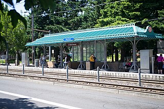
Ruby Junction/East 197th Avenue is a MAX light rail station in Gresham, Oregon. It serves the Blue Line and is the 22nd stop eastbound on the eastside MAX line. The station is at the intersection of SE 197th Avenue and Burnside Street.
East 162nd Avenue station is a MAX light rail station on the boundary between Portland and Gresham in Oregon, USA. It serves the Blue Line and is the 18th stop eastbound on the current Eastside MAX branch.

East 102nd Avenue station is a MAX light rail station in Portland, Oregon. It serves the Blue Line and is the 15th stop eastbound on the current Eastside MAX branch.

East 148th Avenue station is a MAX light rail station in Portland, Oregon. It serves the Blue Line and is the 17th stop eastbound on the current Eastside MAX branch. It is located at the intersection of East Burnside Street and NE/SE 148th Avenue, serving the Hazelwood, Glenfair and Wilkes neighborhoods. The MAX system is owned and operated by TriMet, the major transit agency for the Portland metropolitan area.
Northeast 7th Avenue is a light rail station on the Blue, Green and Red Lines in Portland, Oregon. It is the 9th stop eastbound on the Eastside MAX.

Mall/Southwest 4th Avenue and Mall/Southwest 5th Avenue were a pair of light rail stations in Portland, Oregon, United States, served by TriMet as part of the MAX Light Rail system. Built into the sidewalk at Southwest Yamhill and Morrison streets between 4th and 5th avenues in downtown Portland, the Mall stations were served by the Blue and Red lines upon closing. They had also been served by the Yellow Line from May 2004 to August 2009.
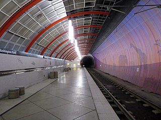
Washington Park is a light rail station in Portland, Oregon, United States, served by TriMet as part of the MAX Light Rail system. Situated between Sunset Transit Center and Goose Hollow/Southwest Jefferson Street station, it is the 17th and 3rd station eastbound on the Blue Line and the Red Line, respectively. The station's two tracks and island platform are part of the Robertson Tunnel beneath Portland's West Hills. Its head house and surface-level plaza occupy the middle of a parking lot surrounded by the Hoyt Arboretum, Oregon Vietnam Veterans Memorial, Oregon Zoo, and World Forestry Center. Washington Park is the only completely underground station in the MAX system. At 260 feet (79 m) below ground, it is the deepest transit station in North America and in the western hemisphere. It is also the seventh-deepest in the world.

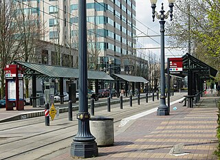
Library/Southwest 9th Avenue and Galleria/Southwest 10th Avenue are light rail stops on the MAX Blue and Red Lines in Portland, Oregon. It was the original western terminus and is now the Eastside MAX line's first stop eastbound/last stop westbound in downtown.

Pioneer Square South and Pioneer Square North are a pair of light rail stations in Portland, Oregon, United States, served by TriMet as part of the MAX Light Rail system. Situated directly west of the Portland Transit Mall at Pioneer Courthouse Square in downtown Portland, they occupy the sidewalk on Yamhill and Morrison streets between Broadway and 6th Avenue. The stations consist of one side platform each; trains traveling eastbound stop at Pioneer Square South while trains traveling westbound stop at Pioneer Square North.
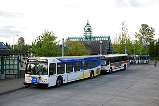
Beaverton Transit Center is a multimodal transport hub in Beaverton, Oregon, United States. Owned and operated by TriMet, it is served by bus, commuter rail, and light rail. The transit center is MAX Light Rail's 15th station eastbound on the Blue Line and western terminus on the Red Line. It is also the northern terminus of WES Commuter Rail and a hub for bus routes mostly serving the westside communities of the Portland metropolitan area. Beaverton Transit Center is situated on Southwest Lombard Avenue, just north of Southwest Canyon Road in central Beaverton, connected by walkway to Canyon Place Shopping Center. It recorded 9,709 average weekday boardings for all modes in fall 2018, making it TriMet's busiest transit center.

Hatfield Government Center is a light rail station on the in downtown Hillsboro, Oregon, United States, owned and operated by TriMet. The station is the western terminus of the MAX Blue Line. Opened in 1998, it is located in the same block as the Hillsboro Post Office and adjacent to the Washington County Courthouse and the Hillsboro Civic Center. The block is bounded by First and Adams streets on the east and west and Washington and Main streets on the south and north. The station is named in honor of Mark O. Hatfield, a former United States Senator from Oregon and light rail proponent. It is the furthest west light rail station in the Continental United States.
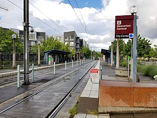
Beaverton Central is a light rail station on the MAX Blue Line in Beaverton, Oregon, United States.

Merlo Road/Southwest 158th Avenue is a light rail station on the MAX Blue Line in Beaverton, Oregon, United States. It is the 10th stop westbound on the Westside MAX.

Washington/Southeast 12th Avenue is a light rail station on the MAX Blue Line in Hillsboro, Oregon. Hillsboro's West Precinct is near the station. Opened in 1998, it is the 17th stop westbound on the Westside MAX, and the last eastbound stop prior to crossing the Main Street Bridge. This is the last stop westbound to be on a grade-separated right-of-way. One block west of here, trains enter the median of Washington Avenue to run through downtown Hillsboro.

Fair Complex/Hillsboro Airport is a light rail station on the MAX Blue Line in Hillsboro, Oregon, United States. It is the 16th stop westbound on the Westside MAX, and the last westbound stop prior to crossing the Main Street Bridge. The station is located close to the Westside Commons – the 2019-adopted new name for the Washington County Fair Complex – and Hillsboro Airport, a major general-aviation facility in Hillsboro, and the location of the Oregon International Airshow in the summer. Bus line 46-North Hillsboro serves the station.
Willow Creek/Southwest 185th Avenue Transit Center is a multimodal transport hub in Hillsboro, Oregon, United States. Owned and operated by TriMet, it is served by bus and light rail. The transit center is the ninth station eastbound on the Blue Line and a hub for bus routes mostly serving Washington County in the Portland metropolitan area. It is located by the intersection of Southwest Baseline Road and 185th Avenue near the city's boundary with Beaverton.

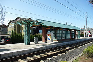
Quatama, formerly Quatama/Northwest 205th Avenue, is a light rail station in Hillsboro, Oregon, United States, that is served by TriMet as part of the MAX Light Rail system. Situated between Orenco station and Willow Creek/Southwest 185th Avenue Transit Center, it is the seventh eastbound station on the Blue Line. The two-track, island platform station includes a park-and-ride lot. Quatama Station is named after the area which includes Quatama Road to the south of the station. Opened in 1998, the stop is near high-tech industries and the Amberglen business park, which includes Oregon Health & Science University's West Campus and the Oregon National Primate Research Center. With the renaming of Northwest 205th Avenue to Northeast John Olsen Avenue by the city of Hillsboro in 2017, TriMet changed the station's name from its original, longer name.
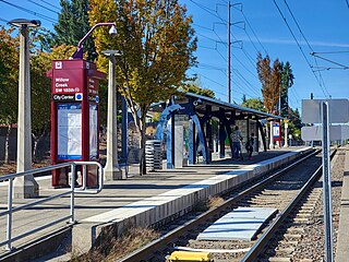
Orenco is a light rail station in Hillsboro, Oregon, United States, served by TriMet as part of the MAX Light Rail system. It is the seventh station eastbound on the Blue Line, situated between the Quatama and Hawthorn Farm stations. The two-track, island platform station serves the Orenco Station neighborhood, which is considered a model for smart growth and transit-oriented development. It features a 125-space park and ride, a bike and ride, and connections to TriMet bus route 47–Baseline/Evergreen and Ride Connection's North Hillsboro Link.

