BBC Radio Shropshire is the BBC's local radio station serving Shropshire.

Known as the Hagley Road in Birmingham, the A456 is a main road in England running between Central Birmingham and Woofferton, Shropshire, south of Ludlow. Some sections of the route, for example Edgbaston near Bearwood, are also the route of the Elan Aqueduct which carries Birmingham's water supply from the Elan Valley.

The A4117 is a single-carriageway 'A road' in western England, largely in Shropshire, which passes through part of the Wyre Forest and Clee Hills.

Church Stretton railway station is a railway station serving the town of Church Stretton in Shropshire, England on the Welsh Marches line, 12+3⁄4 miles (20.5 km) south of Shrewsbury railway station; trains on the Heart of Wales line also serve the station. All trains services are operated by Transport for Wales, who also manage the station.
Ludlow was a rural district in Shropshire, England from 1894 to 1974.

South Shropshire is a county constituency in Shropshire. It was first created in 1832 and was represented by two Knights of the Shire.
The A4113 road is a single-carriageway road that runs from Knighton in Powys to Bromfield in Shropshire, United Kingdom, passing through north Herefordshire.
Ludlow Racecourse is a thoroughbred horse racing venue located in Bromfield near Ludlow, Shropshire, England.
Sunshine Radio (Ludlow) is an Independent Local Radio station based in Ludlow, Shropshire. The station currently serves south Shropshire, north Herefordshire and north Worcestershire.

The River Onny is a river in Shropshire, England. It is a major tributary of the River Teme.

Wild Edric's Way is a waymarked long distance footpath running wholly within the county of Shropshire in England. The path runs for 49 miles (79 km), mostly sharing the route of the Shropshire Way.

The Elan aqueduct crosses Wales and the Midlands of England, running eastwards from the Elan Valley Reservoirs in Mid Wales to Birmingham's Frankley Reservoir, carrying drinking water for Birmingham.

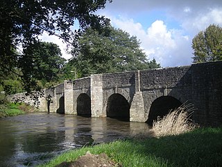
Burway Bridge is a bridge in Ludlow, Shropshire, England. It takes the B4361 road across the River Corve.
The Battle of Arklow was a minor skirmish that took place at Glascarrig on the coast road near Arklow in County Wicklow on 1 November 1649. It was fought between the army of the Parliamentarians and the combined forces of the Irish Royalists and Confederates during the Irish Confederate Wars.

Mortimer Forest is a forest on the Shropshire/Herefordshire border in England, near the town of Ludlow. It covers hilly terrain, including the marilyn of High Vinnalls, rising to 375 metres (1,230 ft).
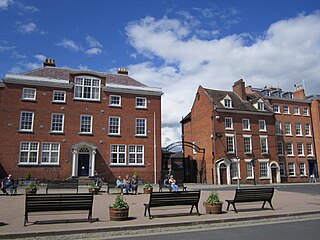
Ludlow College is a sixth form college situated in the heart of Ludlow, Shropshire, England. It now forms part of the Herefordshire and Ludlow College, though retains its own identity.
National Cycle Network Route 44, part of the National Cycle Network, connects Shrewsbury, Shropshire with Cinderford, Gloucestershire. The part of the route from Shrewsbury to Bromfield is signed - the remainder of the route is currently unsigned.

The River Corve is a minor river in Shropshire, England. It is a tributary of the River Teme which it joins in the town of Ludlow, and which joins the River Severn at Powick near Worcester. The valley it flows through is known as the Corvedale, a term used as a general name for the area, and a name used for example by the primary school in Diddlebury. It is sometimes (archaically) spelled "Corf", which is its pronunciation.

Pipe Aston is a small village and civil parish in the far north of Herefordshire, close to the border with Shropshire. It has a population of about 24.

The Corvedale Three Castles Walk is a waymarked recreational circular walk of about 11.5 miles (18.5 km) located in the Corvedale, Shropshire, England. The walk is classed as Easy and Heritage by the Long Distance Walkers Association. The walk nominally starts at the public car park opposite the Swan Inn in Aston Munslow, but other starting points are possible although parking is limited. The walk goes past Broncroft Castle (52.476422°N 2.672107°W), Corfham Castle (earthworks) (52.460758°N 2.700383°W), and Corfton Castle (earthworks) (52.458237°N 2.740205°W). A leaflet is available detailing the walk and can be obtained from some local pubs and retailers. Some bed and breakfasts also have it available. In addition there is a book Castle and Corvedale available from the same sources.
This page is based on this
Wikipedia article Text is available under the
CC BY-SA 4.0 license; additional terms may apply.
Images, videos and audio are available under their respective licenses.
