Emer (Shadow World)

Last updated
Shadow World
Designers Terry K. Amthor
PublishersEidolon Studio, Iron Crown Enterprises, Guild Companion Publications
Publication1987–current
GenresFantasy
LanguagesEnglish
SystemsRolemaster
Media typeGame accessories, novels, role-playing games

In the Shadow World campaign setting, Emer is a continent on Kulthea, where the Grand Campaign takes place. It is the largest contenint on the planet, roughly located within the center of the western hemisphere.

Contents

Culturally, Emer is diverse, and is home for elves, dwarves, and a host of human sub-groups. Lugrôki dwell in the Spine of Emer, while garks are prevalent throughout the tropical forests of the eastern Silaarian peninsula. In its past, vast empires have risen to dominate nearly all of Emer, but today it is largely fragmented politically.

Development history

Emer was first described in the Shadow World Master Atlas, First Edition, [1] published in 1989. In 1990, ICE released Emer: The Great Continent, which described the area in more detail. [2]

At one point during Iron Crown's' financial difficulties in the late 1990s, the rights to Shadow World reverted to its author, Terry Amthor. Amthor produced several works under the name "Eidolon Studios" that explored Emer in more detail.

Geography

Emer can be broken down geographically as follows: Hæstra in the North-west, [3] Tai-emer in the central North, [4] Silaar in the North-east, [4] Uj in the South-west, Khûm-kaan in the central-east, Onar in the far south-east, and Ræl in the far south, and Námar-Tol, a chain of seven large islands, is east of Emer. [4]

Hæstra

Hæstra is the northwest portion of Emer. It is largely fertile, with a mild temperate climate. Abundant natural resources make the region is one of the most densely settled and widely cultivated portions of Emer. The Spine of Emer, a long mountain chain that runs through the entire north-south axis of the continent, borders Hæstra to the east. The Morbek highlands separate Hæstra form the desert plains of Uj to the south. The Bay of Izar forms a portion of the region's southwest border.

Khûm-kaan

Khûm-kaan forms the main southeast block of Emer. It consists of broad plains, dense tropical forest, tall mountainous peaks, and temperate coasts. Its borders are defined by three mountain ranges: The Spine of Emer, the Black Mountains, and the Green Mountains, respectively. A break between the Spine and Emer and the Black Mountains allows access to the Rælian Bay in the southwest, while the Green Mountains, the eastern shore of Lygaar, and the northern shore of Quon form the Bay of Zalkali in the region’s northeast area. The Quon jungle covers nearly three quarters of Khûm-kaan’s total area.

Námar-Tol

Námar-Tol (Loari, "Verdant Towers") is an island east of Emer. It features a mountain in its center, the rest of the island being lush forest and plains.

Onar

Onar is a peninsula stretches east of Khûm-kaan, connected to the mainland by a narrow band of mountainous land. The southern side of the peninsula (running parallel to the peninsula’s east-west axis) consists of stepped and fractured mountains that inherently cut the northern lowlands off from the Swirling Sea to the south, The western portion of the region, closest to Khûm-kaan, is covered by Rulaash Forest, an unexplored and relatively impenetrable jungle. In central Onar is Ahnasan, an area of broad and rolling plains.

Ræl

Ræl is a peninsula in the far south of Emer, desolate and generally uninhabited. It is connected to the Emerian mainland by the southern extent of the Spine of Emer.

Silaar

Silaar is a peninsula on the northeast corner of Emer. It is connected by the Arul waste, a narrow band of desert of Arul, and otherwise separated from the rest of mainland by the Sea of Tears and the Bay of Arûl. There are two mountain ranges along either coast of the peninsula: the Rust Mountains to the west and the Mountains of Ash to the east. The Lake of Glass is at the center of Silaar, sandwiched between the two mountain chains. To the east of the lake is the Værkin Mire, which contains ruins of many cities built by the Thanorian empire before its fall.

Tai-emer

Tai-emer occupies the northeast portion of Emer, bounded by the Spine of Emer on the west (which separates it from Hæstra) while the Sea of Tears and the Bay of Arûl separate Tai-emer from the Silaarian peninsula, located to the east. It consists of flat steppes that tend to be windy, hot, and semi-arid, relieved by several river valleys in the north; and the Arul desert in the south.

Uj

By area, Uj is the largest Emerian region, located south of Hæstra and separated from that region by the Morbek Highlands. Eastern Uj consists of sparsely populated desert and arid plains. The western portion of the region, separated by the Barrier Hills is relatively fertile.


Political entities

Ahnasan

Ahnasan is home to the Kinsai (“cat-people”), so called because of large, six-legged panthers they domesticate and use as mounts.

Bodlea

A collection of rustic villages, each ruled by a local council.

First Emerian Empire

A continent-spanning empire ruled by six Titans known as the Masters of Emer. It rose and fell in the Second Age, and only ruins remain in the canonical "contemporary" timeline.

Itanis

Itanis is an island off the southern coast of Uj. Tropical in climate, it is populated by black-skinned "High Men" ruled by two gender-associated groups: Men who wield mind-magics and a female warrior class.

Kaitaine

A free city in Uj that derives its power primarily from mercantile activity.

Komarran Cluster

A republic situated on an island of the same name. The Republic was founded by a displaced prince of the Second Emerian Empire who found it necessary to flee his home's homophobic policies. A prominent characteristic of the island is acceptance of diverse sexual orientations and criminalization of homophobic utterances and actions.

Lankanôk

A theocracy that occupies the majority of Tai-Emer.

Malqanar

Malqanar is a kingdom of aquatic Elves called Shuliri located at the far eastern extremity of Onar.

Námar-Tol

Námar-Tol is an eponymous island oligarchic republic. There are seven Elven (Loari) families that constitute the ruling class, with all other inhabitants living there on sufferance as heavily regulated "plebeians." There is also a trade city, Orv Cibur (Erlin, Gold Haven), that allows non-resident visitors.

Nuyan-Khôm

Nuyan Khom is a feudal monarchy composed of ten Y'nar Clans or "yani."

Reandor

Reandor is a hereditary monicary located in western Silaar.

Rhiani Horse Clans

The Rhiani are a set of nomadic-based clans known for their skill breeding horses.

Sarnak

A matriarchal representative democracy. Male citizens are disenfranchised and held in a second class.

Sel-kai

Sel-Kai (Erlini (Wood Elven), Silver Cliff) is a city-state and surrounding rural territories on several islands and a peninsula in northern Silaar. [5] It is the continent's, and perhaps the world's, largest trade center. This preeminence is maintained by the near-monopolist possession of flying ships. The city's government and upper social circles display this wealth in large part through the erection and maintenance of Eidolon, a floating city above the eponymous capital.

Stroane

An empire that covers most of the Hæstran sub-continent. It includes what had once been a confederacy of city-states known as Miir and another known as Vornia. In the game's canonical "contemporary" setting, these are recent conquests and the further one is from the capital city of Arakin the looser the Empire's control. In some parts of the empire the priestly hierarchy of the goddess Mynistra remains in open revolt.

Tana

A polity composed of Erlin Elves, indigenous to Námar-Tol who were displaced when the larger island was colonized by the Loari elves.

Ton Bor

A subterranean kingdom of Dwarves generally isolated from the bulk of the continent.

Related Research Articles

<span class="mw-page-title-main">Geography of Russia</span>

Russia is the largest country in the world, covering over 17,125,192 km2 (6,612,074 sq mi), and encompassing more than one-eighth of Earth's inhabited land area. Russia extends across eleven time zones, and has the most borders of any country in the world, with sixteen sovereign nations.

<span class="mw-page-title-main">Geography of Spain</span> Overview of the geography of Spain

Spain is a country located in southwestern Europe occupying most of the Iberian Peninsula. It also includes a small exclave inside France called Llívia, as well as the Balearic Islands in the Mediterranean, the Canary Islands in the Atlantic Ocean 108 km (67 mi) off northwest Africa, and five places of sovereignty on and off the coast of North Africa: Ceuta, Melilla, Islas Chafarinas, Peñón de Alhucemas, and Peñón de Vélez de la Gomera.

Valinor or the Blessed Realm is a fictional location in J. R. R. Tolkien's legendarium, the home of the immortal Valar on the continent of Aman, far to the west of Middle-earth; he used the name Aman mainly to mean Valinor. It includes Eldamar, the land of the Elves, who as immortals are permitted to live in Valinor.

<i>Warhammer Fantasy</i> (setting) High-fantasy setting, created by Games Workshop

Warhammer Fantasy is a fictional fantasy universe created by Games Workshop and used in many of its games, including the table top wargame Warhammer Fantasy Battle, the Warhammer Fantasy Roleplay (WFRP) pen-and-paper role-playing game, and a number of video games: the MMORPG Warhammer Online: Age of Reckoning, the strategy games Total War: Warhammer, Total War: Warhammer II and Total War: Warhammer III and the two first-person shooter games in the Warhammer Vermintide series, Warhammer: End Times - Vermintide and Warhammer: Vermintide 2, among many others.

<span class="mw-page-title-main">Southern Europe</span> Southern region of Europe

Southern Europe is the southern region of Europe. It is also known as Mediterranean Europe, as its geography is marked by the Mediterranean Sea. Definitions of southern Europe include some or all of these countries and regions: Albania, Andorra, Bosnia and Herzegovina, Bulgaria, Croatia, Cyprus, Gibraltar, Greece, Italy, Kosovo, Malta, Monaco, Montenegro, North Macedonia, Portugal, San Marino, Serbia, Slovenia, southern France, Spain, Turkey, and Vatican City.

Faerûn is a fictional continent and the primary setting of the Dungeons & Dragons world of Forgotten Realms. It is described in detail in several editions of the Forgotten Realms Campaign Setting with the most recent being the 5th edition from Wizards of the Coast, and various locales and aspects are described in more depth in separate campaign setting books. Around a hundred novels, several computer and video games and a film use Faerûn as the setting.

<span class="mw-page-title-main">Subregion</span> Part of a larger geographic region or continent

A subregion is a part of a larger region or continent. Cardinal directions are commonly used to define subregions. There are many criteria for creating systems of subregions; this article is focusing on the UN statistical geoscheme, which is a changing, constantly updated, UN tool based on specific political geography considerations relevant in UN statistics.

<span class="mw-page-title-main">Geography of Europe</span>

Europe is traditionally defined as one of seven continents. Physiographically, it is the northwestern peninsula of the larger landmass known as Eurasia ; Asia occupies the centre and east of this continuous landmass. Europe's eastern frontier is usually delineated by the Ural Mountains in Russia, which is the largest country by land area in the continent. The southeast boundary with Asia is not universally defined, but the modern definition is generally the Ural River or, less commonly, the Emba River. The boundary continues to the Caspian Sea, the crest of the Caucasus Mountains, and on to the Black Sea. The Bosporus, the Sea of Marmara, and the Dardanelles conclude the Asian boundary. The Mediterranean Sea to the south separates Europe from Africa. The western boundary is the Atlantic Ocean. Iceland is usually included in Europe because it is over twice as close to mainland Europe as mainland North America. There is ongoing debate on where the geographical centre of Europe falls.

<span class="mw-page-title-main">Pannonian Basin</span> Large sedimentary basin in Central Europe

The Pannonian Basin, or Carpathian Basin, is a large sedimentary basin situated in southeast Central Europe. The geomorphological term Pannonian Plain is more widely used for roughly the same region though with a somewhat different sense, with only the lowlands, the plain that remained when the Pliocene Epoch Pannonian Sea dried out.

<span class="mw-page-title-main">Geography of Korea</span>

Korea comprises the Korean Peninsula and 3,960 nearby islands. The peninsula is located in Northeast Asia, between China and Japan. To the northwest, the Amnok River separates Korea from China and to the northeast, the Duman River separates Korea from China and Russia. The Yellow Sea lies to the west, the East China Sea and Korea Strait to the south, and the Korean East Sea to the east. Notable islands include Jeju Island (Jejudo), Ulleung Island (Ulleungdo), and the Liancourt Rocks.

USA Volleyball (USAV) is a non-profit organization which is recognized as the national governing body of volleyball in the United States by the Fédération Internationale de Volleyball (FIVB) and the United States Olympic Committee (USOC). It is headquartered in Colorado Springs, Colorado, and was founded by the YMCA of the USA. The organization is responsible for selecting and supporting US national teams that compete in FIVB-sanctioned international volleyball and beach volleyball competitions such as the Olympic Summer Games. USA Volleyball is also charged with fostering the development of the sport of volleyball within the United States through involvement with its forty Regional Volleyball Associations (RVAs).

<span class="mw-page-title-main">Geography of North America</span> Overview of the geography of North America

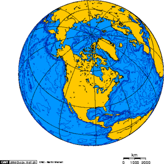
North America is the third largest continent, and is also a portion of the third largest supercontinent if North and South America are combined into the Americas and Africa, Europe, and Asia are considered to be part of one supercontinent called Afro-Eurasia. With an estimated population of 580 million and an area of 24,709,000 km2 (9,540,000 mi2), the northernmost of the two continents of the Western Hemisphere is bounded by the Pacific Ocean on the west; the Atlantic Ocean on the east; the Caribbean Sea on the south; and the Arctic Ocean on the north.

<i>Shadow World</i> (role-playing game)

Shadow World is a high-fantasy campaign setting situated on the fictional planet of Kulthea. Originally produced for the Rolemaster role-playing game system, Shadow World is fairly compatible with other d100 games such as High Adventure Role Playing (HARP), Middle-earth Role Playing (MERP) or Against the Darkmaster. The setting blends traditional fantasy elements, such as elves, dwarves, and magic, with science fiction, including such elements as space and time travel, and, to a degree, futuristic technology.

<span class="mw-page-title-main">Nova Scotia peninsula</span> Peninsula in Nova Scotia

The Nova Scotia peninsula is a peninsula on the Atlantic coast of North America. It is called Enmigtaqamu'g in the Mi'kmaw language.

<span class="mw-page-title-main">Geography of Australia</span>

The geography of Australia encompasses a wide variety of biogeographic regions being the world's smallest continent, while comprising the territory of the sixth-largest country in the world. The population of Australia is concentrated along the eastern and south-eastern coasts. The geography of the continent is extremely diverse, ranging from the snow-capped mountains of the Australian Alps and Tasmania to large deserts, tropical and temperate forests, grasslands, heathlands and woodlands.

<span class="mw-page-title-main">Indian subcontinent</span> Physiographical region in South Asia

The Indian subcontinent is a physiographical region in Southern Asia, mostly situated on the Indian Plate, projecting southwards into the Indian Ocean from the Himalayas. Geopolitically, it spans major landmasses from the countries of Bangladesh, Bhutan, India, the Maldives, Nepal, Pakistan, and Sri Lanka. Although the terms "Indian subcontinent" and "South Asia" are often used interchangeably to denote the region, the geopolitical term of South Asia frequently includes Afghanistan, which is not considered part of the subcontinent.

<span class="mw-page-title-main">Terry K. Amthor</span> American game designer

Terry K. Amthor was an American game designer who worked primarily on role-playing games, and as a fantasy author.

References

  1. Amthor, Terry (1989). Shadow World Master Atlas, 1st Edition. Iron Crown Enterprises. p. 128. ISBN   1-55806-025-1.
  2. Amthor, Terry (1990). Emer: The Great Continent. Iron Crown Enterprises. ISBN   1-55806-126-6.
  3. Amthor, Terry (1997). Emer Book I: Hæstra and the History of theEmerian Empire. ISBN   9781883716127.
  4. 1 2 3 Amthor, Terry (1999). Emer Book II: The Northeast. Eidolon Studios. p. 132. ISBN   1-883716-14-4.
  5. Amthor, Terry (1992). Eidolon: City in the Sky . Iron Crown Enterprises.