
The Sabine River is a 360-mile (580 km) long river in the Southern U.S. states of Texas and Louisiana, From the 32nd parallel north and downstream, it serves as part of the boundary between the two states and empties into Sabine Lake, an estuary of the Gulf of Mexico.
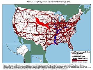
The vast majority of passenger travel in the United States occurs by automobile for shorter distances and airplane or railroad for longer distances. Most cargo in the U.S. is transported by, in descending order, railroad, truck, pipeline, or boat; air shipping is typically used only for perishables and premium express shipments. Transportation is the largest source of greenhouse gas emissions in the United States.

Bowie County is a county in the U.S. state of Texas. Its legal county seat is Boston, though its courthouse is located in New Boston. As of the 2020 census, the population was 92,893. Bowie County is part of the Texarkana metropolitan statistical area. The county is named for James Bowie, the legendary knife fighter who died at the Battle of the Alamo.

Camden is a city in and the county seat of Ouachita County in the south-central part of the U.S. state of Arkansas. The city is located about 100 miles south of Little Rock. Situated on bluffs overlooking the Ouachita River, the city developed because of the river. The recorded history began in 1782 when a Spanish military post was established on the site of an old French trading post called Écore à Fabri. When Ouachita County was formed in 1842, American settlers changed the name to Camden. The city became an important port during the steamboat era when Camden became known as the “Queen City” of the Ouachita. In 1864, Camden became the unintended focus of the Red River Campaign, a major Civil War effort resulting in several significant battles. Camden is known as the producer of M142 HIMARS produced by Lockheed Martin.

Hot Sulphur Springs is a statutory town and the county seat of Grand County, Colorado, United States. The town is located near Byers Canyon between Granby and Kremmling, 95 miles (153 km) northwest of Denver and 30 miles (48 km) northwest of Winter Park. The town population was 687 at the 2020 census. Its elevation is 7,680 feet (2,340 m).

Maud is a city in Bowie County, Texas, United States, within the Texarkana metropolitan area. According to the 2020 U.S. census, it had a population of 977.

Damon is a census-designated place (CDP) in Brazoria County, Texas, United States. The population was 552 at the 2010 census. The town is located about 20 miles (32 km) south of Rosenberg on Texas State Highway 36. Damon sits partly atop a salt dome which was exploited for petroleum, sulphur, and limestone.

Sulphur Springs is a city in and the county seat of Hopkins County, Texas, United States. As of the 2010 census, its population was 15,449. Sulphur Springs is located along the western edge of Northeast Texas.

Washington-on-the-Brazos is an unincorporated community along the Brazos River in Washington County, Texas, United States. The town is best known for being the site of the Convention of 1836 and the signing of the Texas Declaration of Independence.

The Wheeling Suspension Bridge is a suspension bridge spanning the main channel of the Ohio River at Wheeling, West Virginia. It was the largest suspension bridge in the world from 1849 until 1851. Charles Ellet Jr. designed it and supervised construction of what became the first bridge to span a major river west of the Appalachian mountains. It linked the eastern and western section of the National Road, and became especially strategically important during the American Civil War. Litigation in the United States Supreme Court concerning its obstruction of the new high steamboat smokestacks eventually cleared the way for other bridges, especially needed by expanding railroads. Because this bridge was designed during the horse-and-buggy era, 2-ton weight limits and vehicle separation requirements applied in later years until it was closed to automobile traffic in September 2019.

Wright Patman Lake is a reservoir in northeast Texas in the United States. The lake is a U.S. Army Corps of Engineers reservoir formed on the Sulphur River in Bowie and Cass counties by Wright Patman Dam. The reservoir provides flood control and water conservation for the communities downstream from the dam. The lake is also a popular recreational destination. The Bowie County side of the lake is part of the Texarkana metropolitan area.

The Gulf, Colorado and Santa Fe Railway was a subsidiary of the Atchison, Topeka & Santa Fe Railway. From its starting point in Galveston, Texas, the railroad eventually extended northwestwards across the state to Sweetwater and northwards via Fort Worth to Purcell, Oklahoma.

The steamboat Ticonderoga is one of two remaining side-paddle-wheel passenger steamers with a vertical beam engine of the type that provided freight and passenger service on America's bays, lakes and rivers from the early 19th to the mid-20th centuries. Commissioned by the Champlain Transportation Company, Ticonderoga was built in 1906 at the Shelburne Shipyard in Shelburne, Vermont on Lake Champlain.
The Ilwaco Railway and Navigation Company operated a 3 ft narrow gauge railroad that ran for over forty years from the bar of the Columbia River up the Long Beach Peninsula to Nahcotta, Washington, on Willapa Bay. The line ran entirely in Pacific County, Washington, and had no connection to any outside rail line. The railroad had a number of nicknames, including the "Clamshell Railroad" and the "Irregular, Rambling and Never-Get-There Railroad."
The Willamette River flows northwards down the Willamette Valley until it meets the Columbia River at a point 101 miles from the Pacific Ocean, in the U.S. state of Oregon.
Preston, also known as Preston Bend, is an unincorporated community and census-designated place located on the Red River in Grayson County, Texas, United States. It grew in the 19th century at the intersection of several military and trade roads and was an important crossing on the Shawnee cattle trail. Preston lost prominence after the MK&T railroad bypassed the town to the east, leading to a decline in traveler and cattle drive traffic. Much of its former town site is submerged beneath the waters of Lake Texoma. Its population was 2,096 as of the 2010 census.
Ady is an unincorporated historic locale in Klamath County, Oregon, United States.
Grant Prince Marsh was a riverboat pilot and captain who was noted for his many piloting exploits on the upper Missouri River and the Yellowstone River in the Western United States from 1862 until 1882. He began working as a cabin boy in 1856, eventually becoming a captain, pilot, and owner in a career lasting over sixty years. During that time, he achieved an outstanding record and reputation as a steamboat captain, serving on more than 22 vessels. His piloting exploits became legendary and modern historians have referred to him as "possibly the greatest steamboat man ever", "possibly the greatest [steamboat pilot] ever", "possibly the finest riverboat pilot who ever lived", and "the greatest steamboat master and pilot on both the Missouri and Yellowstone Rivers".

Steamboats on the Colorado River operated from the river mouth at the Colorado River Delta on the Gulf of California in Mexico, up to the Virgin River on the Lower Colorado River Valley in the Southwestern United States from 1852 until 1909, when the construction of the Laguna Dam was completed. The shallow draft paddle steamers were found to be the most economical way to ship goods between the Pacific Ocean ports and settlements and mines along the lower river, putting in at landings in Sonora state, Baja California Territory, California state, Arizona Territory, New Mexico Territory, and Nevada state. They remained the primary means of transportation of freight until the advent of the more economical railroads began cutting away at their business from 1878 when the first line entered Arizona Territory.
George A. Johnson & Company was a partnership between three men who pioneered navigation on the Colorado River. Benjamin M. Hartshorne, George Alonzo Johnson and Alfred H. Wilcox. The George A. Johnson & Company was formed in the fall of 1852, and was reorganized as the Colorado Steam Navigation Company in 1869.