
Broadmoor is a gated residential community of 85 acres and golf course of 115 acres in Seattle, Washington, USA. It is bounded on the west by the Washington Park Arboretum, on the south by E. Madison Street, beyond which is the Washington Park neighborhood, on the east by 37th Avenue E., beyond which is the Madison Park neighborhood, and on the north by Union Bay marshland. It was founded on September 10, 1924.

W. Max Finley Stadium is the home stadium for the University of Tennessee at Chattanooga football team, UTC soccer, and Chattanooga FC (NPSL), an amateur Division 4 soccer team. The stadium also hosts various high school sports and musical concerts. It is located in Chattanooga, Tennessee, United States. The stadium, which opened in 1997, has a current capacity of 20,668, and hosted the NCAA Division I National Championship Game from its opening season through 2009, after which the game moved to Pizza Hut Park in the Dallas suburb of Frisco, Texas.
The Samuel Kanyon Doe Sports Stadium is a multi-purpose stadium in Monrovia, Liberia built in 1986. It is used mostly for football matches and has an athletics track, though it has also been used for a reggae concert, political rallies, IDP refuge, and Ebola treatment. The largest stadium in Liberia, its spectator capacity is 35,000.
Entiako Provincial Park and Protected Area is a provincial park in British Columbia, Canada, located on the south flank of the Nechako River watercourse. It was formerly part of Tweedsmuir Provincial Park until that park was broken up; its sibling parks from that change are Tweedsmuir North Provincial Park and Protected Area and Tweedsmuir South Provincial Park.
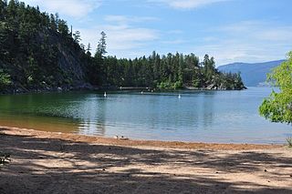
Ellison Provincial Park is a provincial park in British Columbia, Canada, located on the east side of Okanagan Lake to the south of the city of Vernon. The park contains approximately 219 acres (0.89 km2) of land, 200 ha. of it upland, 19 ha. of it foreshore.
Pittsburg, Georgia is a mostly deserted unincorporated community in Walker County, Georgia, United States. It should not be confused with the modern-day city of Pittsburg, DeKalb County, Georgia. The historic settlement of Pittsburg has a Latitude of 34.85944 and a Longitude of -85.43333. It was named after the industrial heritage of Pittsburgh, Pennsylvania.

Shuswap Lake Provincial Park is a provincial park in British Columbia, Canada.

Bingo Stadium (広島県立びんご運動公園陸上競技場) is a multi-use stadium in Onomichi, Hiroshima, Japan. It is currently used mostly for football matches and was used as a venue for the 1992 AFC Asian Cup. The stadium has a capacity of 10,000 people.

Estadio Rubén Guifarro is a multi-purpose stadium in Catacamas, Honduras. It is currently used mostly for football matches and it was home for Atlético Olanchano from 2001 until 2016. The stadium holds 5,000 people. The stadium was renovated for the 2007–08 season. Some of the works included changing the grass turf and increasing the capacity of the stadium. The stadium is also occasionally used by C.D. Motagua as an alternate venue.

Coal Valley Township is located in Rock Island County, Illinois. As of the 2010 census, its population was 4,408 and it contained 1,910 housing units.
Moriles is a town in the province of Córdoba. As of 2005 it had a population of 3,874. The municipality covers an area of about 20 km² and has a population density of about 194 inhabitants/km². The town is located about 65 km sosuth of the provincial capital, Córdoba, at an altitude of 375 m above sea level, at co-ordinates 37°26′0″N4°37′0″W.
Antoinette Tubman Stadium is a multi-purpose stadium in Monrovia, Liberia. It is used mostly for football matches. It has a capacity of 10,000 people
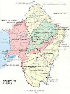
Liberia is the first canton in the province of Guanacaste in Costa Rica. The canton covers an area of 1,436.47 km², and has a population of 67,463.

Clarksburg is an unincorporated community and census-designated place in Fugit Township, Decatur County, Indiana, United States. As of the 2010 census, the population of Clarksburg was 149.
Fonfría is a Spanish municipality in the province of Zamora, Castile and León. It has a population of 1,070 and an area of 132.37 km².

Rampur is a town in Ranchi district, Jharkhand, India.

St. Michael is a hamlet in central Alberta, Canada within Lamont County. It is located 6 kilometres (3.7 mi) north of Highway 29, approximately 42 kilometres (26 mi) northeast of Fort Saskatchewan.

Djerassi Glacier is a 2.8 km long and 1 km wide steep valley glacier situated south of Gorichane Glacier, west of the head of Malpighi Glacier, northwest of the head of Mackenzie Glacier, and north-northeast of Pirogov Glacier on Brabant Island in the Palmer Archipelago, Antarctica. It drains the west slopes of Harvey Heights and the north slopes of Mount Parry, and flows northwestwards into Lanusse Bay north of Venchan Peak.


