| Estero Lampa | |
|---|---|
 | |
| Country | Chile |
The Estero Lampa is a river of Chile.
| Estero Lampa | |
|---|---|
| | |
| Country | Chile |
The Estero Lampa is a river of Chile.

Barrio Bellavista is an area that lies between the Mapocho River and San Cristóbal Hill in Santiago, Chile. It is known as Santiago's bohemian quarter, with numerous restaurants, boutiques, avant-garde galleries, bars and clubs. Many of the city's intellectuals and artists live in Bellavista, and Pablo Neruda's house in Santiago, La Chascona, is in the district. The area is served by the Baquedano Metro subway station, located across the river to the south.

The Biobío River is the second largest river in Chile. It originates from Icalma and Galletué lakes in the Andes and flows 380 km to the Gulf of Arauco on the Pacific Ocean.

Laja River is a river in Chile, along which can be found the Laja Falls. It is located in the Bío Bío Region. The source of the river is Laguna del Laja in the Andes, then flows westward through the Chilean Central Valley and terminates into the Bío Bío River, being an important tributary of it.
The Central Valley, Intermediate Depression, or Longitudinal Valley is the depression between the Chilean Coastal Range and the Andes Mountains. The Chilean Central Valley extends from the border with Peru to Puerto Montt in southern Chile, with a notable interruption at Norte Chico. South of Puerto Montt the valley has a continuation as a series of marine basins up to the isthmus of Ofqui. Some of Chile's most populous cities lie within the valley including Santiago, Temuco, Rancagua, Talca and Chillán.
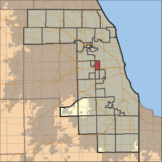
Oak Park Township is one of 29 townships in Cook County, Illinois and its boundaries are coterminous with the village of Oak Park. As of the 2010 census, its population was 51,878.
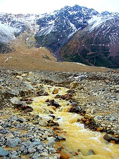
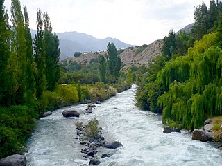
Cajón del Maipo is a canyon located in the Andean southeastern portion of the Santiago Metropolitan Region, Chile. It encompasses the upper Maipo River basin, where the river has entrenched itself in a narrow valley. The zone features a series of confluent rivers such as El Volcán River, Yeso River and Colorado River, as well as other minor streams, including San Gabriel, Manzanito, Coyanco, El Sauce, El Manzano and San José. The main locality is San José de Maipo, capital of the commune that includes all of the Andean sector of the Metropolitan Region. The valley ends almost at the border with Argentina, where it is surrounded by some of the highest peaks in the region, including San José, Maipo, and Marmolejo, the most southerly mountain taller than 6,000 metres (20,000 ft) in the world. Several of the mountains are active volcanoes; San Jose was the most recent to erupt, in 1960.
El Toro Hydroelectric Plant is a hydroelectric power station in Bío Bío Region, Chile. The plant uses water from Laja River and produces 400 megawatts (540,000 hp) of electricity. The plant was built by ENDESA in 1973.

Chos Malal is a department located in the north of Neuquén Province, Argentina.

The Yendegaia River originates from the terminus of Stoppani Glacier in Cordillera Darwin located at southwestern Isla Grande de Tierra del Fuego. Is part of Yendegaia National Park.

The Colorado River is a river of Chile.
The Estero Chacabuco is a river of Chile.
The Estero Coya is a river of Chile.
The Estero La Cadena is a river of Chile.
The Estero Pocuro is a river of Chile.

The Estero Yerba Loca is a river of Chile.
The Yeso River is a river of Chile.
The Muddy River is a 4.7-mile-long (7.6 km) river in Topsham, Maine, which empties into Merrymeeting Bay. The river is also known to be very muddy.

Quibble Island is a river island in the city of Chennai, Tamil Nadu, India. It is formed by the encirclement of the Adyar River and one of its tributaries. It is situated between the neighbourhoods of Mylapore and Adyar. It abuts the southern stretch of the Marina Beach. During the British rule, a European cemetery was located here.
Boneyard is an unincorporated community in Apache County, Arizona, in the United States.
Red Leaf is an unincorporated community in Chicot County, Arkansas, United States.
Coordinates: 33°16′20″S70°53′15″W / 33.27222°S 70.88750°W

A geographic coordinate system is a coordinate system that enables every location on Earth to be specified by a set of numbers, letters or symbols. The coordinates are often chosen such that one of the numbers represents a vertical position and two or three of the numbers represent a horizontal position; alternatively, a geographic position may be expressed in a combined three-dimensional Cartesian vector. A common choice of coordinates is latitude, longitude and elevation. To specify a location on a plane requires a map projection.
| This article related to a river in Chile is a stub. You can help Wikipedia by expanding it. |