Stuart River Provincial Park is a provincial park in British Columbia, Canada. It is located in two sections north and northwest of Vanderhoofalong the Stuart River southeast of Stuart Lake and the city of Fort St. James. The upper section is located at 54°13′20″N124°00′00″W and comprises c.7391 ha. while the lower, eastern section is centred at 54°03′00″N123°37′00″W and comprises c.3390 ha. and is within the Greater Prince George area. The upper site, which is located around the confluence of the Stuart and Nechako Rivers, includes the site of Chinlac, a Dakelh village whose inhabitants were massacred and enslaved by the Tsilhqot'in of Anahim Lake c. 1745.

Bouzeguene is a Kabyle town in Tizi Ouzou Province, Algeria, approximately 170 km from Algiers.

American Samoa is administratively divided into three districts and two "unorganized" atolls. For statistical purposes, the United States Census Bureau reckons these five places as county equivalents. Locally, the districts and unorganized atolls are subdivided into 14 counties and 74 villages.

Cabañas Raras is a village and municipality located in the region of El Bierzo. According to the 2010 census (INE), the municipality has a population of 1,329 inhabitants.

Pagai is a village on the southeast coast of Tutuila Island, American Samoa. It is located on the edge of Faga'itua Bay, and in between the villages of Faga'itua and Alofau. Pagai is six miles east of Pago Pago.
Alega is a village on the southeast coast of Tutuila Island, American Samoa. One of the island's least populous villages, it is located to the east of Pago Pago Harbor and to the west of Faga'itua Bay.
Alofau is a village on the southeast coast of Tutuila Island, American Samoa. It is located at the eastern end of Faga'itua Bay, six miles east of Pago Pago, between Pagai and Amouli. It is home to Alofau Village Marine Protected Area. It is an agrarian and traditional village. It is also a poor village with residents with low literacy and high unemployment rates. As of the U.S. Census 2000, the per capita income was $4,357 and 67 percent of children were below the poverty line. 15.6 percent of residents were receiving public assistance. It is lauded as a kava place in the Manu'a Songs.
Amaua is a village in the southeast of Tutuila Island, American Samoa. It is located on the north shore of Faga'itua Bay between Alega and Faga'itua.
Auto is a village in the east of Tutuila Island, American Samoa. It is located at the western end of Faga'itua Bay, immediately east of Alega.
Faga'alu is a village in central Tutuila Island, American Samoa. It is located on the eastern shore of Pago Pago Harbor, to the south of Pago Pago. American Samoa's lone hospital, Lyndon B. Johnson Tropical Medical Center, is located in Faga'alu. The village is centered around Fagaalu Stream.

Lipen Glacier is a 5 km long and 3.5 km wide glacier draining the east slopes of the Trojan Range on Anvers Island in the Palmer Archipelago, Antarctica. Situated east of Iliad Glacier and north of Rhesus Glacier. Flowing northeastwards into the head of Patagonia Bay east of Gourdon Peninsula and west of Thompson Peninsula.

Nesla Glacier is the 6.2 km long and 2 km wide glacier on Magnier Peninsula, Graham Coast on the west side of Antarctic Peninsula, situated southwest of Muldava Glacier and north of Kolosh Glacier. It drains the west slopes of Lisiya Ridge west of Mount Perchot, and flows westwards into Bigo Bay next north of the terminus of Kolosh Glacier.

Shalom Luani is an American football safety for the Seattle Seahawks of the National Football League (NFL). Luani is better known worldwide for his association football career, having scored against Tonga in American Samoa's first–ever FIFA–sanctioned win. Luani, who now plays as a forward, scored twice for American Samoa in November 2011, making him the country's joint–top goalscorer of all time with fellow forward Ramin Ott.

Kladorub Glacier is the 14 km long and 3.5 km wide glacier on Nordenskjöld Coast in Graham Land situated southwest of Aleksiev Glacier and northeast of Vrachesh Glacier. It drains the southeast slopes of Detroit Plateau, flows southeastwards between Cruyt Spur and Papiya Nunatak, and turns east to enter Desislava Cove in Weddell Sea. The feature is named after the settlement of Kladorub in Northwestern Bulgaria.
Marvin Joey Iosefa is a former American football fullback. He played college football at Hawaii.

Division No. 1, Subdivision E is an unorganized subdivision on the Avalon Peninsula in Newfoundland and Labrador, Canada. It is in Division 1 and contains the unincorporated communities of Broad Cove, Dildo, Green's Harbour, Harnum Point, Hopeall, New Harbour and Reids Room.
Taputimu is a village in southwestern Tutuila Island in American Samoa. It is the nearest village to the Fagatele Bay National Marine Sanctuary, although the main access is from the neighboring village of Futiga. It is home to Leala Shoreline National Natural Landmark and Leala Sliding Rock. It is located in Tualatai County in the Western District of Tutuila.
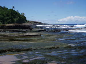
Sa'ilele is a village on the north shore in the Eastern District of Tutuila Island in American Samoa. It is reached from a cross-island road which leads north from the village of Faga'itua. By turning off at the pass, the turn-off takes you down a narrow road through dense forest to Sa'ilele. The village is known for having some of Tutuila’s best swimming beaches. The sandy area below the rock outcrops at the western end of the beach is also a popular site for picnics. On a track east of the village is a burial ground where some ali'i were buried.
Lyndon B. Johnson Tropical Medical Center is the only hospital in American Samoa, and is located in Faga'alu, Maoputasi County. It has been ranked among the best hospitals in the Pacific Ocean. It is home to an emergency room and there are doctors on duty at all hours. It is a 150-bed facility. It includes TB, leprosy and obstetric units. The hospital was built in 1968 and is operating under a $50 million budget as of 2017. The executive director is Taufete'e John Faumuina.


