Hampshire is a ceremonial county in South East England. It is bordered by Berkshire to the north, Surrey and West Sussex to the east, the Isle of Wight across the Solent to the south, Dorset to the west, and Wiltshire to the north-west. The city of Southampton is the largest settlement.
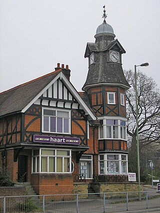
Farnborough is a town located in the Rushmoor district of Hampshire, England. It has a population of around 57,486 as of the 2011 census and is an important centre of aviation, engineering and technology. The town is probably best known for its association with aviation, including the Farnborough International Airshow, Farnborough Airport, Royal Aircraft Establishment, and the Air Accidents Investigation Branch.

A conurbation is a region comprising a number of metropolises, cities, large towns, and other urban areas which, through population growth and physical expansion, have merged to form one continuous urban or industrially developed area. In most cases, a conurbation is a polycentric urbanised area in which transportation has developed to link areas. They create a single urban labour market or travel to work area.

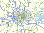
The London metropolitan area is the metropolitan area of London, England. It has several definitions, including the London Travel to Work Area, and usually consists of the London urban area, settlements that share London's infrastructure, and places from which it is practicable to commute to work in London. It is also known as the London commuter belt, or Southeast metropolitan area.

Rushmoor is a local government district with borough status in Hampshire, England. It covers the towns of Farnborough and Aldershot, the former of which is the location of the council.

The River Blackwater is a tributary of the Loddon in England and sub-tributary of the Thames. It rises at two springs in Rowhill Nature Reserve between Aldershot, Hampshire and Farnham, Surrey. It curves a course north then west to join the Loddon in Swallowfield civil parish, central Berkshire. Part of the river splits Hampshire from Surrey; a smaller part does so as to Hampshire and Berkshire.

An urban area is a human settlement with a high population density and an infrastructure of built environment. This is the core of a metropolitan statistical area in the United States, if it contains a population of more than 50,000.

The Nottingham Built-up Area (BUA), Nottingham Urban Area, or Greater Nottingham is an area of land defined by the Office for National Statistics as built-up land with a minimum area of 20 hectares, while settlements within 200 metres of each other are linked. It consists of the city of Nottingham and the adjoining urban areas of Nottinghamshire and Derbyshire, in the East Midlands of England. It had a total population of 729,977 at the time of the 2011 census. This was an increase of almost 10% since the 2001 census recorded population of 666,358, due to population increases, reductions and several new sub-divisions.

Aldershot is a constituency in Hampshire represented in the House of Commons of the UK Parliament.
Mytchett is a village in the Borough of Surrey Heath in Surrey, England, approximately 30 mi (48 km) southwest of central London. It is 2 miles (3 km) to the east of Farnborough, the nearest town. Much of the village dates from the first half of the twentieth century. Mytchett had a population of 4,624 in the 2011 Census.

The Greater Manchester Built-up Area is an area of land defined by the Office for National Statistics (ONS), consisting of the large conurbation that encompasses the urban element of the city of Manchester and the metropolitan area that forms much of Greater Manchester in North West England. According to the United Kingdom Census 2011, the Greater Manchester Built-up Area has a population of 2,553,379 making it the second most populous conurbation in the United Kingdom after the Greater London Built-up Area. This was an increase of 14% from the population recorded at the United Kingdom Census 2001 of 2,240,230, when it was known as the Greater Manchester Urban Area.
The West Yorkshire Built-up Area, previously known as the West Yorkshire Urban Area, is a term used by the Office for National Statistics (ONS) to refer to a conurbation in West Yorkshire, England, based on the cities of Leeds, Bradford and Wakefield, and the large towns of Huddersfield and Halifax. It is the fourth largest urban area in the United Kingdom. However, it excludes other towns and villages such as Featherstone, Normanton, Castleford, Pontefract, Hemsworth, Todmorden, Hebden Bridge, Knottingley, Wetherby and Garforth which, though part of the county of West Yorkshire, are considered independently. There are substantial areas of agricultural land within the designated area – more than in any other official urban area in England – many of the towns and cities are only just connected by narrow outlying strips of development.

The Reading Built-up Area or Reading/Wokingham Urban Area is a name given by the Office for National Statistics to a conurbation in Berkshire, England, with a population of 318,014. This was a significant decrease from the population according to the 2001 census of 369,804 due to Bracknell no longer being considered part of the built-up area, but forming part of the Greater London Urban Area instead.
Blackwater and Hawley is a civil parish in the Hart district of Hampshire, England, on the border with Surrey. According to the 2001 census it had a population of 5,849, reducing to 4,473 at the 2011 Census. The parish includes Minley, Blackwater and Hawley, which are both part of the Aldershot Urban Area. It was once part of the parish of Yateley.

The Sheffield Urban Area is a conurbation in the north of England with a population of 685,368 according to the 2011 census. This was a 7% increase on the 2001 population of 640,720 making it the 8th largest conurbation in the United Kingdom and England's 6th largest. Named the Sheffield Urban Area by the Office for National Statistics, it must not be confused with the Sheffield City Region, a non-government term, although often used, particularly by the business community. In 2001 the population density of the urban area was 3,949.2 people per km2 by 2011 this had increased slightly to 4,092 people per km2.

Blackwater is a town in the Hart District of Hampshire, England. It forms part of the Farnborough/Aldershot Built-up Area and almost is contiguous with Camberley. Blackwater is 32 miles (51 km) from London.

Badshot Lea is a village in Surrey, England, close to Aldershot. Badshot Lea has access in either direction to the A31 and A331 and is connected to railway stations in the nearby towns with regular bus services. The village is part of the Blackwater Valley or Aldershot Urban Area, the thirtieth largest conurbation in the UK. Badshot Lea's boundaries are four bridges—three western railway bridges and Pea Bridge over the uppermost part of the River Blackwater— these inspired a logo for the village and the football team who play in the larger neighbouring village of Ash. The Blackwater separates Badshot Lea from Aldershot to the north; the eastern and western boundaries are short and the southern boundary is the A331.

The Newport Built-up area is an area of land defined by the United Kingdom Office for National Statistics (ONS) for population monitoring purposes. It is an urban conurbation and is not coterminous with the city boundaries. It consists of the urban area centred on Newport as well as contiguous settlements in the eastern and western valleys extending north of the city – including Cwmbran, Pontypool, Risca, Abercarn and Blackwood. It does however exclude physically detached urban areas within the city boundaries, such as Marshfield.

The Wrexham Built-up area is an area of land defined by the United Kingdom Office for National Statistics (ONS) for population monitoring purposes. It is an urban conurbation fully within Wrexham County Borough and consists of the urban area centred on the city of Wrexham. Until the 2021 census, it also included the historically industrial settlements to the west including Gwersyllt, Rhostyllen, Brymbo, Bradley and New Broughton.