Beșghioz is a commune and village in the Gagauz Autonomous Territorial Unit of the Republic of Moldova. The 2004 census listed the commune as having a population of 3,391 people. 93% of its population are Gagauz. Minorities included 76 Russians, 66 Bulgarians, and 46 Moldovans.
Gaidar is a commune and village in the Gagauz Autonomous Territorial Unit of the Republic of Moldova. The 2004 census listed the commune as having a population of 4,525 people. Gagauz total 4,368. Minorities included 32 Moldovans, 47 Russians, 25 Ukrainians, 37 Bulgarians and 12 Roma.
Beșalma is a commune and village in the Gagauz Autonomous Territorial Unit of the Republic of Moldova. The 2004 census listed the commune as having a population of 4,441 people, including 4,293 ethnic Gagauz, 44 Moldovans, 37 Ukrainians, 33 Russians, 25 Bulgarians and 5 Roma.
Chioselia Rusă is a commune and village in the Gagauz Autonomous Territorial Unit of the Republic of Moldova. The 2004 census listed the commune as having a population of 735 people. Gagauz total 185. Other ethnic groups included 266 Moldovans, 23 Russians, 202 Ukrainians, 51 Bulgarians, 4 Romanians and 2 Roma.

Goleni is a village in Edineț District, Moldova.
Domulgeni is a village in Florești District, Moldova.
Ciuflești is a village in Căușeni District, Moldova.
Plop-Știubei is a village in Căușeni District, Moldova.

Codru is a town in Chișinău municipality, Moldova.
Cajba is a village in Glodeni District, Moldova.

Tartaul de Salcie is a commune in Cahul District, Moldova. It is composed of two villages, Tartaul de Salcie and Tudorești. It is situated in the south of Moldova at 433 ft (132 m) above sea level. The population in 2002 was 250.
Cărbuna is a village in Ialoveni District, Moldova.
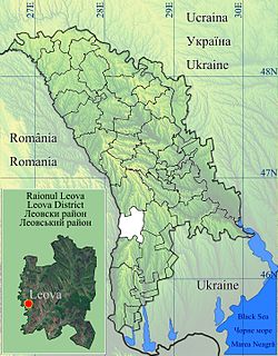
Orac is a village in Leova District, Moldova.
Borogani is a village in Leova District, Moldova.
Sărata Nouă is a commune in Leova District, Moldova. It is composed of two villages: Sărata Nouă and Bulgărica.
Covurlui is a village in Leova District, Moldova.

Chirsova is a commune and village in the Gagauz Autonomous Territorial Unit of the Republic of Moldova. The 2004 census listed the commune as having a population of 6,861 people. Gagauz total 3,128, Bulgarians - 3,326. Minorities included 156 Moldovans, 119 Russians, 98 Ukrainians, 1 Romanian, 9 Roma and 24 'other nationality'.
Andrușul de Sus is a village in Cahul District, Moldova.

Baurci-Moldoveni is a village in Cahul District, Moldova.
Satul Nou is a village in Cimișlia District, Moldova.