Flamingo/Lummus

Last updated
Flamingo/Lummus
Neighborhood of Miami Beach

Flamingo Hotel, 1920s.png

The Flamingo Hotel and surrounding Miami Beach, circa 1920s
Country United States
State Florida
County Miami-Dade County
City Miami Beach
Government
  Miami Beach Mayor Dan Gelber
  Miami-Dade County Commissioner Bruno Barreiro
   House of Representatives Cynthia A. Stafford (D)
   State Senate Gwen Margolis (D)
   U.S. House Ileana Ros-Lehtinen (R)
Area
  Total 0.751 sq mi (1.95 km2)
  Water 0.0 sq mi (0 km2)
Population (2010)
  Total 14,662
Time zone EST (UTC-05)
ZIP Code 33139, 33140
Area code(s) 305, 786

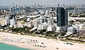
Flamingo/Lummus (often called either Flamingo or Lummus) is an urban neighborhood of South Beach in the city of Miami Beach, Florida, United States. Named for the famed Flamingo Hotel of the early 20th century, it is located in the eastern portion of the main island the city occupies. It is roughly bound by Lincoln Road to the north, 5th Street to the south, Biscayne Bay and Alton Road to the west, and Ocean Drive and Lummus Park to the east. [1]

South Beach Neighborhood of Miami Beach in Miami-Dade County, Florida, United States

South Beach, also nicknamed SoBe, is a neighborhood in the city of Miami Beach, Florida, United States, located due east of Miami city proper between Biscayne Bay and the Atlantic Ocean. The area encompasses all of the barrier islands of Miami Beach south of Indian Creek.

Miami Beach, Florida City in Florida, United States

Miami Beach is a coastal resort city in Miami-Dade County, Florida, United States. It was incorporated on March 26, 1915. The municipality is located on natural and man-made barrier islands between the Atlantic Ocean and Biscayne Bay, the latter of which separates the Beach from Miami. The neighborhood of South Beach, comprising the southernmost 2.5 square miles (6.5 km2) of Miami Beach, along with downtown Miami and the Port of Miami, collectively form the commercial center of South Florida. Miami Beach's estimated population is 92,307 according to the most recent United States census estimates. Miami Beach is the 26th largest city in Florida based on official 2017 estimates from the US Census Bureau. It has been one of America's pre-eminent beach resorts since the early 20th century.

Florida State of the United States of America

Florida is the southernmost contiguous state in the United States. The state is bordered to the west by the Gulf of Mexico, to the northwest by Alabama, to the north by Georgia, to the east by the Atlantic Ocean, and to the south by the Straits of Florida. Florida is the 22nd-most extensive, the 3rd-most populous, and the 8th-most densely populated of the U.S. states. Jacksonville is the most populous municipality in the state and the largest city by area in the contiguous United States. The Miami metropolitan area is Florida's most populous urban area. Tallahassee is the state's capital.

Related Research Articles

Ocean Drive (South Beach)

Ocean Drive is a major thoroughfare in the South Beach neighborhood of Miami Beach.

Belle Isle (Miami Beach) Neighborhood of Miami Beach in Miami-Dade County, Florida, United States

Belle Isle is a neighborhood of South Beach in the city of Miami Beach on a barrier island in Biscayne Bay, Florida, United States. It is the easternmost of the Venetian Islands, a chain of artificial islands in Biscayne Bay in the cities of Miami and Miami Beach. It is home to apartment buildings, a portion of the Venetian Causeway, a city of Miami Beach park, and a hotel. It is between Rivo Alto Island and the main barrier island of Miami Beach.

Flamingo Hotel, Miami Beach

The Flamingo Hotel overlooked Biscayne Bay on the west side of the newly formed city of Miami Beach, Florida, until the 1950s, when it was torn down to make room for the new Morton Towers development, which is now known as the Flamingo South Beach.

Miami Beach Police Department

The Miami Beach Police Department is the police department of the U.S. city of Miami Beach, Florida, patrolling the entire Miami Beach area, although they sometimes cooperate with the county-wide Miami-Dade Police Department.

Pleasant City (West Palm Beach)

Pleasant City is a neighborhood in West Palm Beach, Florida north of 15th Street, and east of Dunbar Village and the Florida East Coast Railway. Established in 1905 and incorporated into the city limits in 1912, it was developed for African-American workers who were employed at area hotels and other businesses.

Brickell Neighborhood of Miami in Miami-Dade County, Florida, United States

Brickell is an urban neighborhood of Greater Downtown Miami, Florida, United States. Directly south of the historic CBD, Brickell is Miami and South Florida's major financial district.

Greater Downtown Miami Neighborhood of Miami in Miami-Dade County, Florida, United States

Downtown Miami is an urban city center, based around the Central Business District of Miami, Florida, United States. In addition to the central business district, the area also consists of the Brickell Financial District, Historic District, Government Center, Arts & Entertainment District and Park West. The neighborhood is divided by the Miami River and is bordered by Midtown to the north, Biscayne Bay to the east, Civic Center and Overtown to the west, and Coconut Grove to the south.

Ludlam Road, also West 67th Avenue, is a 21.8-mile (35.1 km) north–south street that runs west of downtown Miami in Miami-Dade County, Florida.

Lummus Park Historic District Neighborhood of Miami in Miami-Dade County, Florida, United States

The Lummus Park Historic District or simply Lummus Park, is on the National Register of Historic Places and a locally historic designated district in Miami, Florida. It is roughly bound by Northwest Fifth Street to the north, Flagler Street to the south, Northwest Third Avenue to the east, and the Miami River to the west. On October 25, 2006, it was added to the U.S. National Register of Historic Places. Lummus Park has some of the oldest structures in Miami, and over the decades, has been able to retain a large part of its early pioneer character.

Rivo Alto Island is a neighborhood of South Beach in the city of Miami Beach on a man-made island in Biscayne Bay, Florida, United States. It is one of the Venetian Islands, a chain of artificial islands in Biscayne Bay in the cities of Miami and Miami Beach. It is between Di Lido Island and Belle Isle. It is home to residential neighborhoods and a portion of the Venetian Causeway.

North Beach (Miami Beach) Neighborhood of Miami Beach in Miami-Dade County, Florida, United States

North Beach is a neighborhood of the city of Miami Beach, Florida, United States. It is the northernmost section of the city, roughly bound by 63rd Street and Indian Creek Drive to the south and 87th Terrace to the north. It collectively refers to neighborhoods including Isles of Normandy, Biscayne Point, and La Gorce.

Dodge Island island in the United States of America

Dodge Island is an artificial island near downtown Miami, Florida, United States. The Port of Miami is located on Dodge Island and has berths for both cruise and cargo ships.

The Roads Neighborhood of Miami in Miami-Dade County, Florida, United States

The Roads is a neighborhood of Miami in Miami-Dade County, Florida, United States. It is a triangular area located south of SW 11th Street, between SW 12th Avenue and SW 15th Road, just west of Brickell.

Coral Way Neighborhood of Miami in Miami-Dade County, Florida, United States

Coral Way is a neighborhood within Miami, Florida that is defined by Coral Way, a road established by Coral Gables founder George E. Merrick during the 1920s. It is located in Miami-Dade County, Florida, United States.

Isle of Normandy or Normandy Island or Normandy Isles or Normandy Isle is a neighborhood of North Beach in the city of Miami Beach, Florida, United States. It is located along the eastern shore of Biscayne Bay.

South Pointe Park

South Pointe Park, known locally as South Pointe, is a 17-acre (6.9 ha) county urban park in metropolitan Miami, in the South Beach neighborhood of Miami Beach, Florida.

City Center is a neighborhood of South Beach in the city of Miami Beach, Florida, United States. The area is roughly bound by Dade Boulevard and 23rd Street to the north, Lincoln Road to the south, Alton Road and Biscayne Bay to the west, and the Atlantic Ocean to the east.

Mid-Beach Neighborhood of Miami Beach in Miami-Dade County, Florida, United States

Mid-Beach is a section of the city of Miami Beach, Florida, United States. It is portion of the city which encompasses the area north of 23rd Street and the Indian Creek and south of Surprise Lake and 63rd Street. It collectively refers to neighborhoods including Oceanfront, Bayshore, and Nautilus.

References

Coordinates: 25°46′58″N80°08′11″W / 25.782851°N 80.136423°W / 25.782851; -80.136423

Geographic coordinate system Coordinate system

A geographic coordinate system is a coordinate system that enables every location on Earth to be specified by a set of numbers, letters or symbols. The coordinates are often chosen such that one of the numbers represents a vertical position and two or three of the numbers represent a horizontal position; alternatively, a geographic position may be expressed in a combined three-dimensional Cartesian vector. A common choice of coordinates is latitude, longitude and elevation. To specify a location on a plane requires a map projection.