
Aust-Agder was a county (fylke) in Norway until 1 January 2020, when it was merged with Vest-Agder to form Agder county. In 2002, there were 102,945 inhabitants, which was 2.2% of Norway's population. Its area was 9,212 square kilometres (3,557 sq mi). The county's administrative center was the town of Arendal.

Åmli is a municipality in Agder county, Norway. It is located in the traditional region of Sørlandet. The main population centre and administrative center is the village of Åmli which lies along the river Nidelva. Other villages in Åmli include Askland, Dølemo, Eppeland, Flaten, Hillestad, Homdrom, Lauveik, Nelaug, Øvre Ramse, Skjeggedal, Tveit, Vehus, and Ytre Ramse.

Nelaug is a village in the southern part of the municipality of Åmli in Agder county, Norway. The population (2001) was 161. The village lies at east of the Nelaug lake, which is regulated by a hydroelectric power plant. The most notable feature in the village is the train station, Nelaug Station, which is the junction between the main Sørland Line and the branch Arendal Line. Nelaug school is a 1st through 6th grade elementary school. It is one of the three schools in Åmli municipality. Nelaug sits at the end of Norwegian County Road 412 which connects Nelaug to the Norwegian County Road 415 and the rest of Norway.

Nidelva is the main river in the Arendal drainage basin in Agder county, Norway. The 221.7-kilometre (137.8 mi) long river begins at the confluence of two rivers: Nisserelva and Fyreselv. The confluence is located by the village of Haugsjåsund in Nissedal municipality in southern Vestfold og Telemark county. The river flows south into the Skagerrak at the city of Arendal. The watershed covers 4,011 square kilometres (1,549 sq mi) and has an average waterflow of 114.4 cubic metres per second (4,040 cu ft/s) at Rykene near the mouth. The highest waterflow ever recorded on the river was 1,200 cubic metres per second (42,000 cu ft/s) in the autumn of 1987.

Tovdal is a former municipality in the old Aust-Agder county in Norway. The 377-square-kilometre (146 sq mi) municipality existed from 1908 until its dissolution in 1967. Tovdal municipality was made up of the valley surrounding the river Tovdalselva and since 1967 it has been a part of the present-day municipality of Åmli which is now in Agder county. The administrative centre of the municipality was the village of Hillestad where the Tovdal Church is located.

Gjøvdal is a former municipality in the old Aust-Agder county in Norway. The municipality existed from 1908 until its dissolution in 1960. It covered the Gjøv river valley and the surrounding moors. It is currently part of the municipality of Åmli in Agder county. The administrative centre was the village of Askland where Gjøvdal Church is located.
Vegår is a lake in the municipality of Vegårshei in Agder county, Norway. The 17.7-square-kilometre (6.8 sq mi) lake is located about 3 kilometres (1.9 mi) north of the municipal center of Myra and about 12 kilometres (7.5 mi) east of the village of Åmli in the neighboring municipality of Åmli.
Nasvatn is a lake in the municipality of Åmli in Agder county, Norway. It is located about 3.5 kilometres (2.2 mi) north of the village of Hillestad in the mountains above the Tovdal river valley. The lake has a small dam on the southwestern end, and the water leaving the lake goes down a large waterfall and eventually drains in the river Tovdalselva.
Nelaug is a lake in the municipalities of Froland and Åmli in Agder county, Norway. The 10 kilometres (6.2 mi) lake is formed by a dam which regulates a hydroelectric power plant on the Nidelva river. The village of Nelaug is located near the dam in Froland municipality. The lake is located about 11 kilometres (6.8 mi) south of the village of Åmli, about 15 kilometres (9.3 mi) southeast of the village of Dølemo, and about 20 kilometres (12 mi) north of Blakstad.
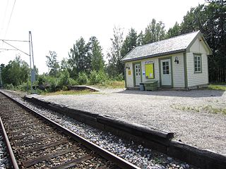
Flaten Station is a railway station at the village of Flaten in Åmli municipality in Agder county, Norway. Located along the Arendalsbanen railway line, it is served by Go-Ahead Norge. The station was opened in 1910 as part of Arendal–Åmli Line.
Flaten is a village in the municipality of Åmli in Agder county, Norway. It is located along the river Nidelva, about 4 kilometres (2.5 mi) southeast of the village of Nelaug. The population (2001) of Flaten was 32. The village has a railway station, Flaten Station, which is part of the Arendalsbanen railway line.

Norwegian county road 415 (Fv415) is a Norwegian county road in Agder county, Norway. The 37.3-kilometre (23.2 mi) long highway runs between the European route E18 highway at Fiane in Tvedestrand municipality and the Norwegian National Road 41 at Myråsen, just south of the village of Åmli in Åmli municipality. The Norwegian County Road 412 splits off from this road to connect to Nelaug and the Nelaug Station. The Norwegian County Road 414 connects to this road at Ubergsmoen and heads north into Vegårshei.

Norwegian county road 412 (Fv412) is a Norwegian county road in Åmli municipality in Agder county, Norway. The 4.59-kilometre (2.9 mi) long road runs between the Norwegian County Road 415 at the village of Hovde and Nelaug Station in the village of Nelaug.
Eppeland is a village in Åmli municipality in Agder county, Norway. The village is located along the Norwegian National Road 41, about 1.5 kilometres (0.93 mi) northeast of the village of Dølemo and about 10 kilometres (6.2 mi) southwest of the municipal centre of Åmli.

Aust-Agder District Court was a district court in Agder county, Norway. The court was based in the town of Arendal. The court existed from 2004 until 2021. It had jurisdiction over the eastern part of the county which included the municipalities of Grimstad, Arendal, Froland, Åmli, Tvedestrand, Vegarshei, Risør, and Gjerstad. Cases from this court could be appealed to Agder Court of Appeal.
Ås is the Scandinavian language word for an esker, a ridge of sand and gravel.

Østre Agder is a district or region in Agder county in southern Norway. The district covers the eastern, coastal areas of the county including the eight municipalities of Arendal, Tvedestrand, Risør, Grimstad, Gjerstad, Vegårshei, Åmli, and Froland. The city of Arendal is the largest city in the region. Other cities in the district include Tvedestrand, Grimstad, and Risør. This region is bounded by Telemark county to the north, by the Setesdal region to the northwest, and by the Kristiansand Region to the southwest.

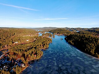
Åmli is the administrative centre of Åmli municipality in Agder county, Norway. The village is located along the Norwegian National Road 41 and the river Nidelva, about 30 kilometres (19 mi) northwest of the town of Tvedestrand via the Norwegian County Road 415. The village of Nelaug lies about 15 kilometres (9.3 mi) to the southeast and the village of Dølemo lies about 10 kilometres (6.2 mi) to the southwest. The 0.81-square-kilometre (200-acre) village has a population (2019) of 697 which gives the village a population density of 855 inhabitants per square kilometre (2,210/sq mi).

Mykland is a former municipality in the old Aust-Agder county in Norway. The 306-square-kilometre (118 sq mi) municipality existed from 1876 until 1967 when it was merged into the neighboring municipality of Froland in what is now Agder county. Mykland included the inland areas between the rivers Tovdalsåna and the Rettåna. The administrative centre was the village of Mykland where the Mykland Church is located.