
Roseau is the capital and largest city of Dominica, with a population of 14,725 as of 2011. It is a small and compact urban settlement, in the Saint George parish and surrounded by the Caribbean Sea, the Roseau River and Morne Bruce. Built on the site of the ancient Island Carib village of Sairi, it is the oldest and most important urban settlement on the island of Dominica.

iSimangaliso Wetland Park is situated on the east coast of KwaZulu-Natal, South Africa, about 235 km (146 mi) north of Durban by road. It is South Africa's third-largest protected area, spanning 280 km (170 mi) of coastline, from the Mozambican border in the north to Mapelane south of the Lake St. Lucia estuary, and made up of around 3,280 km2 of natural ecosystems, managed by the iSimangaliso Authority.

Gros Islet District, one of 10 first order subdivision of the Caribbean island nation of Saint Lucia which includes the island's northernmost point, Cap Point and the notable Cap Estate, where the renowned St. Lucia Golf and Country Club is located. Whilst the town of Gros Islet is an important administrative centre, Rodney Bay is the main financial center of the district.

Vieux Fort is one of 10 districts of the Caribbean island country of Saint Lucia. Vieux Fort is also the name of the main town in the district. It is the home of the second-largest town in Saint Lucia and is the home of Saint Lucia's international airport, Hewanorra International Airport.
Soufrière is a district on the Southwest coast of Saint Lucia in the West Indies. Soufrière was the former capital of Saint Lucia during times of French rule. It is now a small fishing port with an emerging tourism industry. It has several tourist sites, including a "drive-in" volcano, the Diamond Botanical Gardens with waterfall and historic mineral baths, plus the nearby beaches of Anse Chastanet to the north and Malgretout to the south.

Dennery District is one of 10 districts of the Caribbean island nation of Saint Lucia. The seat of Dennery District is the Dennery Village. The main economic activities are fishing, and the cultivation of lima beans, bananas, and other tropical fruit. The population of the quarter was estimated at 12,876 in 2002 and fell to 12,767 in 2010.
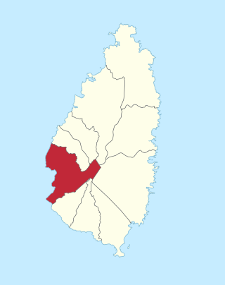
Anse la Raye District is one of 10 districts of the island nation of St. Lucia in the Caribbean Sea. The name Anse la Raye is French for cover/bay of the rays, since there are a large number of skate fish or rays in the bay. In 2005/2010, the population of the district was 6,382/6,060 people, and they are mainly fishers and agricultural workers. The main town in the area takes the same name as the district and is located down the western coast from Castries, the capital of the country.
The Saint Lucia Jazz and Arts Festival is an annual event on the Caribbean island of Saint Lucia that brings together local and international musicians and other performing artists, as well as artisans. The festival presents jazz, R&B, and Calypso music, dance, theatre, and international couture.

Micoud District is one of 10 districts of the Caribbean island nation of Saint Lucia The seat of this district is the town of Micoud inside this district. According to the 2002 census, the population of the district was 16,143 people. The final 2010 Census recorded a population of 16,284 in Micoud District. A former quarter, Praslin Quarter, was merged into Micoud Quarter. It was not enumerated separately in the 2010 Census. The 2001 Census shows Praslin as part of Micoud District.
The Fond d'Or River is a river in Saint Lucia. It rises in the centre of the island, flowing north and then east to its mouth in Fond d'Or Bay, close to the village of Dennery on the central east coast.
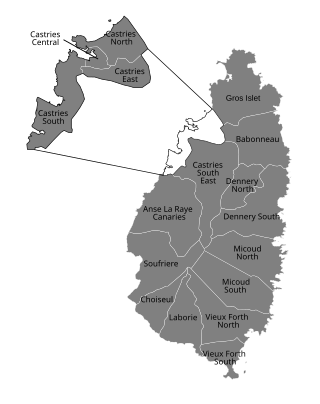
Babonneau is one of the regions of the Caribbean island nation of Saint Lucia. Babonneau is located in the north of the island in the Castries Quarter. There are extensive rain forests in the region, which is an important source of fresh water for Saint Lucia. Babonneau is also an electoral constituency of Saint Lucia represented in the House of Assembly of Saint Lucia, which extends into Gros Islet District.

Saint Lucia, an island nation in the Caribbean islands, has a relatively large tourism industry. Due to the relatively small land area of the country, most of the governmental promotion is performed by the state-operated Saint Lucia Tourism Authority, led by Executive Chairperson Agnes.

The Roseau Valley is a second-order subdivision in the island nation of St. Lucia. It is home to the island's largest banana plantation. The 2010 population of the Roseau Valley was 227.

Allerey is a commune in the Côte-d'Or department in the Bourgogne-Franche-Comté region of eastern France.
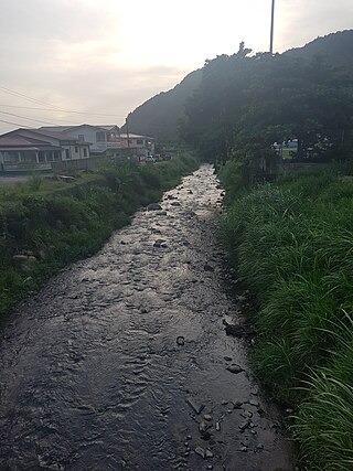
The Soufrière River is a river in the Soufrière Quarter on the island country of Saint Lucia. The French term "Soufrière" is a generic one referring to "Sulphury" volcanic peaks called La Soufrière or Soufrière Hills on each of St. Vincent, St. Lucia, Dominica, Guadeloupe.
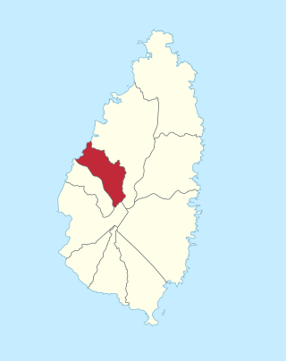
Anse La Raye or Anse-La-Raye is the largest town and seat of the Anse la Raye District of Saint Lucia. It is located on the island's western side, near Marigot Bay, and has several examples of French and English colonial architecture.
Ti Rocher is a town in the Micoud District of the island nation of Saint Lucia. It is also a 2nd level division in Micoud District.
The Fond River is a river of Saint Lucia.

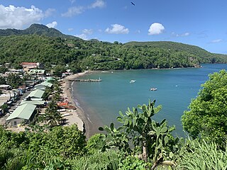
Soufrière is a town on the West Coast of Saint Lucia, in the eastern Caribbean Sea. The town and the surrounding district has a population of 7,935. It was colonized by the French and was the original capital of the island.
Choc Bay is a bay in Gros Islet Quarter on the island nation of Saint Lucia; it is along the northwestern coast of the island. The Choc River flows into the bay.

