
Loughton is a town and civil parish in the Epping Forest District of Essex, within the metropolitan and urban area of London, England. Situated 12 miles (19 km) north-east of Charing Cross, the town borders Waltham Abbey, Theydon Bois, Chigwell, Chingford, and Buckhurst Hill.

Epping Forest District is a local government district in Essex, England. It is named after the ancient woodland of Epping Forest, a large part of which lies within the district. The district covers northeastern parts of the London urban area, including the towns of Epping, Loughton, Waltham Abbey, Chigwell, and Buckhurst Hill, as well as rural areas beyond it. The district is situated in the west of the county, bordering north-eastern Greater London.

The Stort Navigation is the canalised section of the River Stort running 22 kilometres (14 mi) from the town of Bishop's Stortford, Hertfordshire, downstream to its confluence with the Lee Navigation at Feildes Weir near Rye House, Hoddesdon, Hertfordshire.
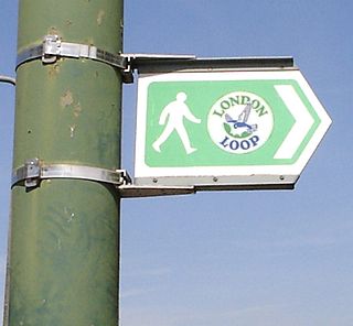
The London Outer Orbital Path — more usually the "London LOOP" — is a 150-mile (242 km) signed walk along public footpaths, and through parks, woods and fields around the edge of Outer London, England, described as "the M25 for walkers". The walk begins at Erith on the south bank of the River Thames and passes clockwise through Crayford, Petts Wood, Coulsdon, Banstead, Ewell, Kingston upon Thames, Uxbridge, Elstree, Cockfosters, Chingford, Chigwell, Grange Hill and Upminster Bridge before ending at Purfleet, almost directly across the Thames from its starting point. Between these settlements the route passes through green buffers and some of the highest points in Greater London.

The Essex Way is a waymarked long-distance footpath 81 miles (130 km) long, along footpaths and roads in Essex, England.
Walking is a popular recreational activity in London, despite traffic congestion. There are many streets that provide interesting walks, especially within historic central London, In addition there are attractive commons, parks, canals, and disused railway tracks that provide space for walks. This includes Wimbledon Common, Epping Forest, Hampstead Heath, and the eight Royal Parks: Hyde Park, Regent's Park, Richmond Park, etc. In recent years access to canals and rivers, including the Regent's Canal, and the River Thames has been greatly improved, and as well a number of long-distance walking routes have been created that link green spaces.

Hatfield Forest is a 403.2-hectare (996-acre) biological Site of Special Scientific Interest in Essex, three miles east of Bishop's Stortford. It is also a National Nature Reserve and a Nature Conservation Review site. It is owned and managed by the National Trust. A medieval warren in the forest is a Scheduled Monument.

The Lea Valley Walk is a 50-mile (80 km) long-distance path located between Leagrave, the source of the River Lea near Luton, and the Thames, at Limehouse Basin, Limehouse, east London. From its source much of the walk is rural. At Hertford the path follows the towpath of the River Lee Navigation, and it becomes increasingly urbanised as it approaches London. The walk was opened in 1993 and is waymarked throughout using a swan logo.

Epping is a market town and civil parish in the Epping Forest District of Essex, England. Part of the metropolitan and urban area of London, it is 17 miles (30 km) north-east of Charing Cross. It is surrounded by the northern end of Epping Forest, and on a ridge of land between the River Roding and River Lea valleys.

High Beach is a village inside Epping Forest in south-west Essex, England. Part of the civil parish of Waltham Abbey, the village is within the Epping Forest District and the ward of Waltham Abbey High Beach, and lies approximately 11 miles (18 km) north-east of Charing Cross.

Pincey Brook is a watercourse in the Uttlesford and Epping Forest districts of Essex, England, and is a tributary to the River Stort.

St Peter's Way is a long-distance footpath in Essex, England. The 41-mile (66 km) path leads from Chipping Ongar to the 7th-century Chapel of St Peter-on-the-Wall at Bradwell-on-Sea. It is waymarked, and shown on Ordnance Survey mapping.

The Saffron Trail is a long-distance footpath in Essex, England. The 71-mile (114 km) path leads from the pier in Southend-on-Sea to St Mary's church in Saffron Walden. It is waymarked, and shown on Ordnance Survey mapping.
The Thames Estuary Path is a long-distance footpath in Essex, England. The 29-mile path leads from Tilbury to Leigh-on-Sea. It is waymarked, but as of 2024 is not named on Ordnance Survey mapping.

The Three Forests Way is a long-distance footpath in Essex and Hertfordshire, England. The 59-mile (95 km) circular path passes through three forests in west Essex. It is waymarked, and named on Ordnance Survey mapping.

The Roach Valley Way is a long-distance footpath in south-east Essex, England. The 23-mile circular path is centred on Rochford and the River Crouch and Roach estuaries. It is waymarked, and named on Ordnance Survey mapping.
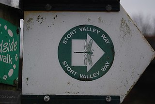
The Stort Valley Way is a long-distance footpath in west Essex, England. The 30-mile circular path is centred on Harlow and the Stort Navigation. It is waymarked, and named on Ordnance Survey mapping.
The Epping Forest Centenary Walk is a long-distance footpath from East London to Epping Forest. It is also known as Epping Forest Big Walk. The 15-mile (24 km) path runs from Manor Park to Epping Forest using, where possible, green corridors.
The John Ray Walk is a linear footpath from Braintree to Witham in Essex. The 9-mile (14.4 km) footpath follows the valley of the River Brain.