Fort Confidence

Last updated

Fort Confidence
at the mouth of the Dease River on the eastern tip of the Dease Arm of Great Bear Lake, Northwest Territories Canada
Great Bear Lake (de).png
Fort Confidence on the northeast shore of Great Bear Lake
Coordinates 66°53′28″N119°02′53″W / 66.89111°N 119.04806°W / 66.89111; -119.04806
Typepost
Site information
Controlled by Hudson's Bay Company
Site history
Built1837

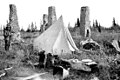
Fort Confidence, located at the mouth of the Dease River on the eastern tip of the Dease Arm of Great Bear Lake, Northwest Territories, was a Hudson's Bay Company establishment (not a trading post), built in 1837 by Peter Warren Dease and Thomas Simpson as a base for their exploration of the Arctic coast. It served as a quarters for two winters. The structure was a log building, and burned down a short time later. In 1848, the post was rebuilt by John Bell and used by Sir John Richardson and Dr. John Rae as a base of operations during the search for famous explorer Sir John Franklin, who went missing along the Arctic Coast. These buildings were still standing in 1902, but had again been destroyed by fire by 1911 when George M. Douglas's expedition to the Coppermine River passed through the area. The remains of this fort consist of four stone and clay chimneys.

Fort Confidence was featured in Jules Verne's book The Fur Country .

Related Research Articles

<span class="mw-page-title-main">Hudson's Bay Company</span> Canadian retail business group, former fur trading business

The Hudson's Bay Company is a Canadian retail business group. A fur trading business for much of its existence, it became the largest and oldest corporation in Canada, and now owns and operates retail stores across the country. The company's namesake business division is Hudson's Bay, commonly referred to as The Bay.

<span class="mw-page-title-main">Victoria Island</span> Island in Arctic Canada

Victoria Island is a large island in the Arctic Archipelago that straddles the boundary between Nunavut and the Northwest Territories of Canada. It is the eighth-largest island in the world, and at 217,291 km2 (83,897 sq mi) in area, it is Canada's second-largest island. It is nearly double the size of Newfoundland (111,390 km2 [43,010 sq mi]), and is slightly larger than the island of Great Britain (209,331 km2 [80,823 sq mi]) but smaller than Honshu (225,800 km2 [87,200 sq mi]). The western third of the island lies in the Inuvik Region of the Northwest Territories; the remainder is part of Nunavut's Kitikmeot Region. The population of 2,168 is divided among 2 settlements, the larger of which is in Nunavut and the other of which is in the Northwest Territories.

<span class="mw-page-title-main">John Rae (explorer)</span> Scottish explorer

John Rae was a Scottish surgeon who explored parts of northern Canada.

Fort Edmonton was the name of a series of trading posts of the Hudson's Bay Company (HBC) from 1795 to 1914, all of which were located on the north banks of the North Saskatchewan River in what is now central Alberta, Canada. It was one of the last points on the Carlton Trail, the main overland route for Metis freighters between the Red River Colony and the points west and was an important stop on the York Factory Express route between London, via Hudson Bay, and Fort Vancouver in the Columbia District. It also was a connection to the Great Northland, as it was situated relatively close to the Athabasca River whose waters flow into the Mackenzie River and the Arctic Ocean. Located on the farthest north of the major rivers flowing to the Hudson Bay and the HBC's shipping posts there, Edmonton was for a time the southernmost of the HBC's forts.

<span class="mw-page-title-main">George Simpson (HBC administrator)</span> Scottish colonial administrator and explorer

Sir George Simpson was a Scottish explorer and colonial governor of the Hudson's Bay Company during the period of its greatest power. From 1820 to 1860, he was in practice, if not in law, the British viceroy for the whole of Rupert's Land, an enormous territory of 3.9 millions square kilometers corresponding to nearly forty percent of modern-day Canada.

<span class="mw-page-title-main">George Back</span> British Royal Navy admiral (1796–1878)

Admiral Sir George Back was a British Royal Navy officer, explorer of the Canadian Arctic, naturalist and artist. He was born in Stockport.

Dease Lake is a small community in the Cassiar Country of the Northern Interior of British Columbia, Canada. It is 230 km south of the Yukon border on Stewart–Cassiar Highway at the south end of the lake of the same name. Dease Lake is the last major centre before the Alaska Highway while driving northbound, and also the junction to Telegraph Creek and the Grand Canyon of the Stikine. Dease Lake Indian Reserve No. 9 is nearby and is under the governance of the Tahltan First Nation band government.

Samuel Black was a Scottish fur trader and explorer, a clerk in the New North Nest Company (XYC) and Wintering Partner in the North West Company (NWC), and later clerk, chief trader, and chief factor in the Hudson's Bay Company (HBC) for the Columbia District. In 1824, he explored the Finlay River and its tributaries in present-day north-central British Columbia, Canada, including the Muskwa, Omineca and Stikine for the HBC. His journals were published by the Hudson's Bay Record Society in 1955.

John McLeod was a Scottish-born explorer of Canada, in his capacity as a fur trader with the North West Company and Hudson's Bay Company. He is remembered primarily for his explorations of several major rivers of the southwestern Northwest Territories, southern Yukon Territory, and northern British Columbia.

Henry John Moberly, also known as Harry or Harvey (1835–1931) was a fur trader. He entered the Hudson's Bay Company's service in 1854, and in 1862 was in charge of the post on Stuart Lake; gave his name to Moberly Lake in the Peace River country. After nearly 40 years service, retired in Saskatchewan, in 1894.

<span class="mw-page-title-main">History of the Northwest Territories</span> Aspect of history

The history of the Northwest Territories covers the period from thousands of years ago to the present day. Prior to European colonization, the lands that encompass present-day Northwest Territories were inhabited for millennia by several First Nations. European explorers and fur traders began to explore the region since the late-16th century. By the 17th century, the British laid claim to both the North-Western Territory and Rupert's Land; and granted the Hudson's Bay Company a commercial fur trade monopoly over the latter region.

<span class="mw-page-title-main">Uvayuq</span> Mountain in Nunavut, Canada

Uvayuq, formerly Ovayok or Mount Pelly, is an esker in the Kitikmeot Region, Nunavut. It is located in northern Canada on Victoria Island within the Ovayok Territorial Park. The hill, which is more than 200 m (660 ft) high, is located 15 km (9.3 mi) north east of the hamlet of Cambridge Bay, Nunavut.

Fort McLoughlin was a fur trading post established in 1833 by the Hudson's Bay Company (HBC) on Campbell Island in present-day British Columbia, Canada. At the time the Hudson's Bay Company performed quasi-governmental duties on behalf of the British Empire as well as undertaking trade for profit. The site is believed to have been at McLoughlin Bay on the northeast side of Campbell Island and is associated with the relocation of the Heiltsuk community of Bella Bella from its former location on islets near Denny Island. The McLoughlin name, which is that of John McLoughlin, regional head of company operations at that time, is also found in a lake and a creek entering that bay, and was conferred on these locations after the fort had closed.

<span class="mw-page-title-main">Thomas Simpson (explorer)</span> Scottish explorer

Thomas Simpson was a Scottish Arctic explorer, Hudson's Bay Company fur trader, and cousin of Company Governor Sir George Simpson. He helped chart the northern coasts of Canada. He died by violence near the Turtle River while traveling through the wilderness in what is now the U.S. state of North Dakota but was then part of the Territory of Iowa. The circumstances of his final hours—in which he allegedly killed himself after gunning down two companions—have long been a subject of controversy.

Peter Warren Dease was a Canadian fur trader and Arctic explorer.

Dease Lake is a lake in the Stikine Plateau of the Northern Interior of British Columbia, Canada, located at the head of the Dease River, which flows north then northeast from the lake to join the Liard River. The community of Dease Lake, British Columbia, formerly Dease Lake Post, is located at the south end of the lake, straddling a low pass which leads into the basin from the Tanzilla River, a tributary of the Stikine. The area around the lake was the focus of the Cassiar Gold Rush and numerous ghost towns and former settlement sites are scattered around its shores, including Laketon and Centre City. Dease Lake is the burial site and has a monument to English travelogue writer Warburton Pike.

<span class="mw-page-title-main">John Pelly</span>

Sir John Henry Pelly, 1st Baronet, DL was an English businessman. During most of his career, he was an employee of the Hudson's Bay Company (HBC), serving as Governor of the HBC for three decades. He held other noteworthy offices, including Governor of the Bank of England. The title of Baronet Pelly was created for him.

The Rae–Richardson Arctic expedition of 1848 was an early British effort to determine the fate of the lost Franklin Polar Expedition. Led overland by Sir John Richardson and John Rae, the party explored the accessible areas along Franklin's proposed route near the Mackenzie and Coppermine rivers. No contact with Franklin's party was achieved and Rae later interviewed the Inuit of the region, from whom he obtained credible accounts that the desperate remnants of Franklin's party had resorted to cannibalism. This revelation was so unpopular that Rae was shunned by the Admiralty and popular opinion; the search for Franklin continued for several years.

<span class="mw-page-title-main">Timeline of European exploration</span>

This timeline of European exploration lists major geographic discoveries and other firsts credited to or involving Europeans during the Age of Discovery and the following centuries, between the years AD 1418 and 1957.

<span class="mw-page-title-main">Mackenzie River expedition</span>

The Mackenzie River expedition of 1825–1827 was the second of three Arctic expeditions led by explorer John Franklin and organized by the Royal Navy. Its goal was the exploration of the North American coast between the mouths of the Mackenzie and Coppermine rivers and Bering Strait, in what is now present-day Alaska, Yukon, the Northwest Territories, and Nunavut. Franklin was accompanied by George Back and John Richardson, both of whom he had previously collaborated with in the disastrous Coppermine expedition of 1819–1821. Unlike Franklin's previous expedition, this one was largely successful, and resulted in the mapping of more than 1,000 km (620 mi) of new coastline between the Coppermine River and Prudhoe Bay, Alaska, an area that until then had remained largely unexplored by Europeans.