
Fort Hall is a census-designated place (CDP) in the southeastern part of the U.S. state of Idaho which is split between Bannock County in the south and Bingham County in the north. It is located on the Fort Hall Indian Reservation along the Snake River north of Pocatello and near the site of the original Fort Hall in the Oregon Country. The population was 3,201 at the 2010 census.

Hin-mah-too-yah-lat-kekt, popularly known as Chief Joseph, Young Joseph, or Joseph the Younger, was a leader of the Wal-lam-wat-kain (Wallowa) band of Nez Perce, a Native American tribe of the interior Pacific Northwest region of the United States, in the latter half of the 19th century. He succeeded his father Tuekakas in the early 1870s.
The Shoshone or Shoshoni are a Native American tribe with four large cultural/linguistic divisions:
Fort Hall was a fort that was built in 1834 as a fur trading post by Nathaniel Jarvis Wyeth. It was located on the Snake River in the eastern Oregon Country, now part of present-day Bannock County in southeastern Idaho, United States. Mr. Wyeth was an inventor and businessman from Boston, Massachusetts, who also founded a post at Fort William, in present-day Portland, Oregon, as part of a plan for a new trading and fisheries company. Unable to compete with the powerful British Hudson's Bay Company, based at Fort Vancouver, in 1837 Wyeth sold both posts to it. Great Britain and the United States both operated in the Oregon Country in these years.

Chief Pocatello was a leader of the Northern Shoshone, a Native American people of the Great Basin in western North America. He led attacks against early settlers during a time of increasing strife between settlers and Native Americans. After making peace with the U.S. Government, he moved his people to their present reservation in Idaho and led the Shoshone during their struggle to survive following their deportation. The city of Pocatello is named in his honor.

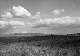
The Fort Hall Reservation is a Native American reservation of the federally recognized Shoshone-Bannock Tribes in the U.S. state of Idaho. This is one of five federally recognized tribes in the state. The reservation is located in southeastern Idaho on the Snake River Plain about 20 miles (32 km) north and west of Pocatello. It comprises 814.874 sq mi (2,110.51 km2) of land area in four counties: Bingham, Power, Bannock, and Caribou. To the east is the 60-mile-long (97 km) Portneuf Range; both Mount Putnam and South Putnam Mountain are located on the Fort Hall Reservation.
The Bannock War of 1878 was an armed conflict between the U.S. military, Bannock and Paiute warriors in Idaho and Northeastern Oregon from June to August 1878. The Bannock totaled about 600 to 800 in 1870 because of other Soshonean peoples being included with Bannock numbers; they were led by Chief Buffalo Horn, who was killed in action on June 8, 1878. After his death, Chief Egan led the Bannocks. He and some of his warriors were killed in July, by a Umatilla party that entered his camp in subterfuge.
The Bannock tribe were originally Northern Paiute but are more culturally affiliated with the Northern Shoshone. They are in the Great Basin classification of Indigenous People. Their traditional lands include northern Nevada, southeastern Oregon, southern Idaho, and western Wyoming. Today they are enrolled in the federally recognized Shoshone-Bannock Tribes of the Fort Hall Reservation of Idaho, located on the Fort Hall Indian Reservation.

Winnemucca,, was a Northern Paiute war chief. He was born a Shoshone around 1820 in what would later become the Oregon Territory.

The Duck Valley Indian Reservation was established in the 19th century for the federally recognized Shoshone-Paiute Tribe. It is isolated in the high desert of the western United States, and lies directly on the state line, the 42nd parallel, between Idaho and Nevada.

Sacagawea was a Lemhi Shoshone woman who, at age 16, helped the Lewis and Clark Expedition in achieving their chartered mission objectives by exploring the Louisiana Territory. Sacagawea traveled with the expedition thousands of miles from North Dakota to the Pacific Ocean, helping to establish cultural contacts with Native American populations and contributing to the expedition's knowledge of natural history in different regions.

Washakie is a ghost town in far northern Box Elder County, Utah, United States. Lying some 3 miles (4.8 km) southeast of Portage, it was established in 1880 by The Church of Jesus Christ of Latter-day Saints for the settlement of the Northwestern Shoshone. The Washakie Indian Farm was home to the main body of this Native American band through most of the 20th century. By the mid-1970s, Washakie's residents were gone and the property sold to a private ranching operation. Today the tribal reservation consists of a small tract containing the Washakie cemetery, and the tribe is seeking to acquire more of the surrounding land. The old LDS chapel in Washakie is now on the National Register of Historic Places.

The history of Idaho in the American Civil War is atypical, as the territory was far from the battlefields.

Eastern Shoshone are Shoshone who primarily live in Wyoming and in the northeast corner of the Great Basin where Utah, Idaho and Wyoming meet and are in the Great Basin classification of Indigenous People. They lived in the Rocky Mountains during the 1805 Lewis and Clark Expedition and adopted Plains horse culture in contrast to Western Shoshone that maintained a Great Basin culture.

The Lemhi Shoshone are a tribe of Northern Shoshone, also called the Akaitikka, Agaidika, or "Eaters of Salmon". The name "Lemhi" comes from Fort Lemhi, a Mormon mission to this group. They traditionally lived in the Lemhi River Valley and along the upper Salmon River in Idaho. Bands were very fluid and nomadic, and they often interacted with and intermarried other bands of Shoshone and other tribes, such as the Bannock. Today most of them are enrolled in the Shoshone-Bannock Tribes of the Fort Hall Reservation of Idaho.
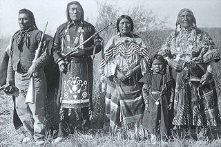
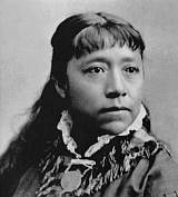
Benedicte Marie Wrensted was a notable Danish-American photographer, who emigrated to the United States after running a studio for a few years in Horsens, Denmark. She was an obscure photographer who is most notably remembered for her documentation of the Northern Shoshone, Lemhi, and Bannock tribes in Idaho between 1895-1912.
The Lemhi Reservation was a United States Indian Reservation for the Lemhi Shoshone from 1875 to 1907. During almost all this time their main chief was Tendoy.

The Bannock War of 1895, or the Bannock Uprising, refers to a minor conflict centered in Jackson Hole, Wyoming, in the United States. During the early 1890s, Wyoming passed a state law prohibiting the killing of elk for their teeth, which led to the arrests of several Bannock hunters in 1895. The arrests and the death of one Bannock created wildly exaggerated rumors that the natives would revolt; at one point, the Eastern press reported that the Bannocks had massacred a large group of settlers in Jackson Hole. In response, the United States Army launched an expedition into the area- when troops arrived, it was found that the situation was peaceful and that the fears of uprising were unjustified.
Northern Shoshone are Shoshone of the Snake River Plain of southern Idaho and the northeast of the Great Basin where Idaho, Wyoming and Utah meet. They are culturally affiliated with the Bannock people and are in the Great Basin classification of Indigenous People.
The Fort McDermitt Paiute and Shoshone Tribe is a federally recognized tribe of Northern Paiute and Western Shoshone peoples, whose reservation Fort McDermitt Paiute and Shoshone Tribes of the Fort McDermitt Indian Reservation spans the Nevada and Oregon border next to Idaho, USA. The reservation has 16,354 acres in Nevada and 19,000 acres in Oregon.