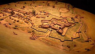
Fort Duquesne was a fort established by the French in 1754, at the confluence of the Allegheny and Monongahela rivers. It was later taken over by the English, and later Americans, and developed as Pittsburgh in the U.S. state of Pennsylvania.

Fort McHenry is a historical American coastal pentagonal bastion fort located in the Locust Point neighborhood of Baltimore, Maryland. It is best known for its role in the War of 1812, when it successfully defended Baltimore Harbor from an attack by the British navy from the Chesapeake Bay on September 13–14, 1814. It was first built in 1798 and was used continuously by the U.S. armed forces through World War I and by the Coast Guard in World War II. It was designated a national park in 1925, and in 1939 was redesignated a "National Monument and Historic Shrine".

The Capture of Fort Ticonderoga occurred during the American Revolutionary War on May 10, 1775, when a small force of Green Mountain Boys led by Ethan Allen and Colonel Benedict Arnold surprised and captured the fort's small British garrison. The cannons and other armaments were later transported to Boston by Colonel Henry Knox and used to fortify Dorchester Heights and break the standoff at the Siege of Boston.

The Battle of Fort Sumter was the bombardment of Fort Sumter near Charleston, South Carolina by the Confederate States Army, and the return gunfire and subsequent surrender by the United States Army, that started the American Civil War. Following the declaration of secession by South Carolina on December 20, 1860, its authorities demanded that the U.S. Army abandon its facilities in Charleston Harbor. On December 26, Major Robert Anderson of the U.S. Army surreptitiously moved his small command from the vulnerable Fort Moultrie on Sullivan's Island to Fort Sumter, a substantial fortress built on an island controlling the entrance of Charleston Harbor. An attempt by U.S. President James Buchanan to reinforce and resupply Anderson using the unarmed merchant ship Star of the West failed when it was fired upon by shore batteries on January 9, 1861. South Carolina authorities then seized all Federal property in the Charleston area except for Fort Sumter.

The Lewis and Clark National and State Historical Parks, in the vicinity of the mouth of the Columbia River, commemorate the Lewis and Clark Expedition. Administration of the parks is a cooperative effort of the United States National Park Service and the states of Oregon and Washington, and was dedicated on November 12, 2004.

Fort Monroe is a decommissioned military installation in Hampton, Virginia at Old Point Comfort, the southern tip of the Virginia Peninsula, United States. Along with Fort Wool, Fort Monroe originally guarded the navigation channel between the Chesapeake Bay and Hampton Roads—the natural roadstead at the confluence of the Elizabeth, the Nansemond and the James rivers. Until disarmament in 1946, the areas protected by the fort were the entire Chesapeake Bay and Potomac River regions, including the water approaches to the cities of Washington, D.C. and Baltimore, Maryland, along with important shipyards and naval bases in the Hampton Roads area. Surrounded by a moat, the six-sided bastion fort is the largest fort by area ever built in the United States.

Fort Fisher was a Confederate fort during the American Civil War. It protected the vital trading routes of the port at Wilmington, North Carolina, from 1861 until its capture by the Union in 1865.
The fort was located on one of Cape Fear River's two outlets to the Atlantic Ocean on what was then known as Federal Point or Confederate Point and today is known as Pleasure Island. The strength of Fort Fisher led to its being called the Southern Gibraltar and the "Malakoff Tower of the South.". The battle of Fort Fisher was the most decisive battle of the Civil War fought in North Carolina.
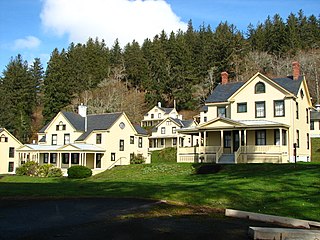
Fort Columbia State Park is a public recreation area and historic preserve at the site of former Fort Columbia, located on Chinook Point at the mouth of the Columbia River in Chinook, Washington. The 618-acre (250 ha) state park features twelve historic wood-frame fort buildings as well as an interpretive center and hiking trails. The park's grounds are located over a tunneled section of U.S. Route 101.
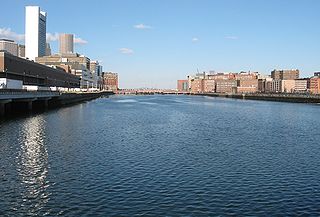
Fort Point Channel is a maritime channel separating South Boston from downtown Boston, Massachusetts, feeding into Boston Harbor. The south part of it has been gradually filled in for use by the South Bay rail yard and several highways. At its south end, the channel once widened into South Bay, from which the Roxbury Canal continued southwest where the Massachusetts Avenue Connector is now. The Boston Tea Party occurred at its northern end. The channel is surrounded by the Fort Point neighborhood, which is also named after the same colonial-era fort.
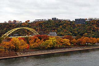
Point State Park is a Pennsylvania state park on 36 acres (150,000 m2) in Downtown Pittsburgh, Allegheny County, Pennsylvania, USA, at the confluence of the Allegheny and Monongahela rivers, forming the Ohio River.

Golkonda, also known as Golconda, Gol konda, or Golla konda, is a citadel and fort in Southern India and was the capital of the medieval sultanate of the Qutb Shahi dynasty (c.1512–1687), is situated 11 km (6.8 mi) west of Hyderabad. It is also a tehsil of Hyderabad district, Telangana, India. The region is known for the mines that have produced some of the world's most famous gems, including the Koh-i-Noor, the Hope Diamond, Nassak Diamond and the Noor-ul-Ain.
Millers Point is an inner-city suburb of Sydney, in the state of New South Wales, Australia. It is on the north-western edge of the Sydney central business district, adjacent to The Rocks and is part of the local government area of the City of Sydney.

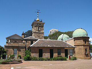
Dawes Point is a suburb of the City of Sydney, in the state of New South Wales, Australia. Dawes Point is located on the north-western edge of the Sydney central business district, at the southern end of Sydney Harbour Bridge, adjacent to The Rocks. At times Dawes Point has been considered to be part of The Rocks, or known as West Rocks, part of Millers Point, or part of it known as Walsh Bay.

McLeod Lake is an unincorporated community located on Highway 97 in northern British Columbia, Canada, 140 km (87 mi) north of Prince George. It is notable for being the first continuously inhabited European settlement established west of the Rocky Mountains in present-day Canada.

Crown Point State Historic Site is the site of a former military stronghold at the south end of the wider part of Lake Champlain. The location is in Essex County, New York, United States. The site is on a peninsula in the town of Crown Point, New York.

Fort Baker is one of the components of California's Golden Gate National Recreation Area. The Fort, which borders the City of Sausalito in Marin County and is connected to San Francisco by the Golden Gate Bridge, served as an Army post until the mid-1990s, when the headquarters of the 91st Division moved to Parks Reserve Forces Training Area. It is located opposite Fort Point at the entrance to the San Francisco Bay.

Fort Taber District or the Fort at Clark's Point is a historic American Civil War-era military fort on Wharf Road within the former Fort Rodman Military Reservation in New Bedford, Massachusetts. The fort is now part of Fort Taber Park, a 47-acre town park located at Clark's Point. Fort Taber was an earthwork built nearby with city resources and garrisoned 1861-1863 until Fort Rodman was ready for service.

Acushnet Fort was a fort that existed from 1776 to around 1820 on Eldridge Point in New Bedford, Massachusetts. It was originally built with Commonwealth resources during the American Revolution in 1776 with ten guns. Rebuilt in 1808 under the federal second system of fortifications, it could accommodate 40 men and had six guns and a magazine.


