Fort Point (Greenwich Island)

Last updated
Location of Greenwich Island in the South Shetland Islands. Greenwich-Island-location-map.png
Location of Greenwich Island in the South Shetland Islands.
Fort Point from Bransfield Strait, with St. Kiprian Peak and Lyutitsa Nunatak in the background. Greenwich Island Antarctica Dec06B.jpg
Fort Point from Bransfield Strait, with St. Kiprian Peak and Lyutitsa Nunatak in the background.
Topographic map of Livingston Island, Greenwich, Robert, Snow and Smith Islands. Livingston-Island-Map-2010.jpg
Topographic map of Livingston Island, Greenwich, Robert, Snow and Smith Islands.

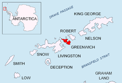
Fort Point is a conspicuous rocky point rising to 85 m and linked by a low 700 m isthmus to the southeast coast of Greenwich Island in the South Shetland Islands, Antarctica. The feature's name is descriptive, replacing the earlier version 'Castle Rock'.

South Shetland Islands A group of islands north of the Antarctic Peninsula

The South Shetland Islands are a group of Antarctic islands with a total area of 3,687 square kilometres (1,424 sq mi). They lie about 120 kilometres (75 mi) north of the Antarctic Peninsula, and between 430 kilometres (270 mi) to 900 kilometres (560 mi) south-west from the nearest point of the South Orkney Islands. By the Antarctic Treaty of 1959, the islands' sovereignty is neither recognized nor disputed by the signatories and they are free for use by any signatory for non-military purposes.

Antarctica Polar continent in the Earths southern hemisphere

Antarctica is Earth's southernmost continent. It contains the geographic South Pole and is situated in the Antarctic region of the Southern Hemisphere, almost entirely south of the Antarctic Circle, and is surrounded by the Southern Ocean. At 14,000,000 square kilometres, it is the fifth-largest continent. For comparison, Antarctica is nearly twice the size of Australia. About 98% of Antarctica is covered by ice that averages 1.9 km in thickness, which extends to all but the northernmost reaches of the Antarctic Peninsula.

Contents

Location

The point is located at 62°32′35″S59°34′31″W / 62.54306°S 59.57528°W / -62.54306; -59.57528 which is 4.56 km east-northeast of Sartorius Point, 1.62 km east of St. Kiprian Peak and 4.9 km south by west of Santa Cruz Point. British mapping in 1968, Chilean in 1971, Argentine in 1980, and Bulgarian in 2005 and 2009.

Sartorius Point

Sartorius Point is a sharp ice-free tipped point formed by an offshoot of Viskyar Ridge and marking the south extremity of Greenwich Island in the South Shetland Islands, Antarctica. The point separates the termini of Zheravna Glacier to the west and Targovishte Glacier to the east. The area was visited by early 19th century sealers.

St. Kiprian Peak mountain in Greenwich Island, South Shetland Islands, Antarctica

St. Kiprian Peak is a rocky peak of elevation 270 m in the southeast extremity of Breznik Heights on Greenwich Island, Antarctica. Situated 1.54 km east of Vratsa Peak, 1.7 km south of Ilarion Ridge, 1.63 km west of Fort Point, and 800 m northeast of Kormesiy Peak. Overlooking Musala Glacier to the north. Bulgarian topographic survey Tangra 2004/05.

Santa Cruz Point

Santa Cruz Point, also Spencer Bluff, is a rocky point forming the east extremity of Greenwich Island in the South Shetland Islands, Antarctica and the southwest side of the entrance to English Strait. Surmounted by Bogdan Ridge on the west.

Maps

International Standard Book Number Unique numeric book identifier

The International Standard Book Number (ISBN) is a numeric commercial book identifier which is intended to be unique. Publishers purchase ISBNs from an affiliate of the International ISBN Agency.

Related Research Articles

Kaloyan Nunatak

Kaloyan Nunatak is a conspicuous nunatak in the Tangra Mountains. It is named after Czar Kaloyan of Bulgaria, 1197-1207 AD.

Mesta Peak

Mesta Peak is a conspicuous, sharp and narrow rocky peak extending 500 m in east-west direction and rising to approximately 400 m in Delchev Ridge, Tangra Mountains, eastern Livingston Island in the South Shetland Islands, Antarctica. The peak has steep and ice-free slopes and surmounts the east extremity of Sopot Ice Piedmont to the north.

Murgash Glacier

Murgash Glacier is the 3.4 km long and 3.2 km wide glacier on Greenwich Island in the South Shetland Islands, Antarctica situated southeast of Yakoruda Glacier, south of Teteven Glacier, southwest of Traub Glacier and west-northwest of Bravo Glacier. It is bounded by Lloyd Hill on the northwest, Tile Ridge on the east and Hebrizelm Hill on the southeast, and drains southwards into Kramolin Cove in McFarlane Strait between Yovkov Point and Kaspichan Point.

Musala Glacier

Musala Glacier on Greenwich Island in the South Shetland Islands, Antarctica is situated northeast of Targovishte Glacier, east-northeast of Zheravna Glacier and southeast of Fuerza Aérea Glacier. It is bounded by St. Kiprian Peak to the south, Vratsa Peak to the southwest, central Breznik Heights to the west, and Ilarion Ridge bordering Hardy Cove to the northeast, extends 2 nautical miles in east-west direction and 1.2 nautical miles in north-south direction, and drains eastwards into Bransfield Strait north of Fort Point.

Paisiy Peak

Paisiy Peak rises to approximately 550 m in the Delchev Ridge, Tangra Mountains, eastern Livingston Island in the South Shetland Islands, Antarctica surmounting Sopot Ice Piedmont to the north and east.

Rila Point

Rila Point is a low, ice-free point on the south coast of Moon Bay, projecting 330 m west-northwestwards from Burgas Peninsula on Livingston Island in the South Shetland Islands, Antarctica, and forming the east side of the entrance to Bruix Cove. The point is named after Rila Mountain, Bulgaria.

Shabla Knoll hill on the South Shetland Islands, Antarctica

Shabla Knoll rises to over 400 m (1,312 ft) in Delchev Ridge, Tangra Mountains, Livingston Island in the South Shetland Islands, Antarctica surmounting Sopot Ice Piedmont to the north and Pautalia Glacier to the southwest.

Shishman Peak

Shishman Peak rises to over 800 m in the east extremity of Levski Ridge, Tangra Mountains, eastern Livingston Island in the South Shetland Islands, Antarctica. The peak overlooks Iskar Glacier and Bruix Cove to the north-northeast and Magura Glacier to the south. The peak is named after Czar Ivan Shishman of Bulgaria, 1371-1395 AD.

Teteven Glacier glacier in Antarctica

Teteven Glacier is a glacier on Greenwich Island in the South Shetland Islands, Antarctica situated east of Yakoruda Glacier, west of Quito Glacier, northwest of Traub Glacier and north of Murgash Glacier. It extends 6.5 km in east-west direction and 3.8 km in north-south direction, and drains the north slopes of Dryanovo Heights into the Drake Passage in Haskovo Cove and Skaptopara Cove between Miletich Point and the ice-free area at Agüedo Point.

Dragoman Glacier

Dragoman Glacier is a 1.4 nautical miles long glacier on Smith Island, South Shetland Islands draining the southeast slopes of Imeon Range southeast of Zavet Saddle and south of the summit Mount Foster. It is situated southeast of Bistra Glacier, southwest of Landreth Glacier and northeast of Armira Glacier, and flows southeastward into Ivan Asen Cove, Osmar Strait. Bulgarian early mapping in 2009. The glacier is named after the town of Dragoman in western Bulgaria.

Ephraim Bluff

Ephraim Bluff is a 425 m ice-free bluff in the south of Breznik Heights, Greenwich Island in the South Shetland Islands, Antarctica. The bluff is linked to Razgrad Peak to the north-northeast and separates the termini of Wulfila Glacier to the northwest and Zheravna Glacier to the east.

Triangle Point

Triangle Point is the low ice-free tipped point forming the northwest side of the entrance to Shopski Cove in the south coast of Parvomay Neck linking the northwest and southeast parts of Greenwich Island in the South Shetland Islands, Antarctica. The area was frequented by early 19th century sealers operating from Yankee Harbour.

Bajo Nunatak

Bajo Nunatak is a conspicuous rocky peak rising to 210 m at the south edge of the ice cap of Robert Island in the South Shetland Islands, Antarctica. The nunatak surmounts Zahari Point to the southeast, Micalvi Cove to the east-southeast, and English Strait to the southwest.

Cecilia Island

Cecilia Island is the ice-free southernmost island of the Aitcho group on the west side of English Strait in the South Shetland Islands, Antarctica. Extending 910 by 450 m, surface area 36 hectares. The area, visited by American and English sealers in the early 19th century, nowadays has become a popular tourist site frequented by Antarctic cruise ships.

Ongley Island

Ongley Island is a rugged rocky island lying off the north coast of Greenwich Island in the South Shetland Islands, Antarctica. Extending 1.35 km (0.84 mi) in west-northwest direction and 470 m (510 yd) wide, with a surface area of 44 hectares. The area was visited by early 19th century sealers.

Agüedo Point

Agüedo Point is the point forming the north extremity of Greenwich Island in the South Shetland Islands, Antarctica and the west side of the entrance to Guayaquil Bay. The adjacent ice-free area of Flamingo Beach on the west covers 80 hectares, and ends in Terimer Point, the east entrance point of Skaptopara Cove.

Aspis Island

Aspis Island is a small, low-lying, ice-free island rising to 15 metres (49 ft), easternmost in the Dunbar group off the northwest coast of Varna Peninsula, Livingston Island in the South Shetland Islands, Antarctica.

Gabriel Hill

Gabriel Hill is the summit of Half Moon Island in the South Shetland Islands, Antarctica. It is a rocky hill rising to 101 m in the island’s northwest extremity and surmounting Moon Bay to the west and Menguante Cove to the southeast. The area was visited by early 19th century sealers operating from nearby Yankee Harbour.

Xenia Hill

Xenia Hill is the rocky hill rising to 96 m in the northeast extremity of Half Moon Island in the South Shetland Islands, Antarctica. It surmounts McFarlane Strait to the north and east, and Menguante Cove to the south-southeast. The area was visited by early 19th century sealers operating from nearby Yankee Harbour.

References