Lyutitsa Nunatak

Last updated
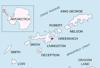
Location of Greenwich Island in the South Shetland Islands. Greenwich-Island-location-map.png
Location of Greenwich Island in the South Shetland Islands.
Lyutitsa Nunatak (in the background) from Bransfield Strait, with St. Kiprian Peak on the left and Fort Point in the foreground. Greenwich Island Antarctica Dec06B.jpg
Lyutitsa Nunatak (in the background) from Bransfield Strait, with St. Kiprian Peak on the left and Fort Point in the foreground.
Topographic map of Livingston Island, Greenwich, Robert, Snow and Smith Islands. Livingston-Island-Map-2010.jpg
Topographic map of Livingston Island, Greenwich, Robert, Snow and Smith Islands.

Lyutitsa Nunatak (Nunatak Lyutitsa \'nu-na-tak lyu-'ti-tsa\) is a rocky peak of elevation 430 m projecting from the ice cap in Breznik Heights on Greenwich Island, Antarctica. Overlooking Musala Glacier to the north, east, and south. Bulgarian topographic survey Tangra 2004/05.

Breznik Heights

Breznik Heights rises to over 600 m in the southeast part of Greenwich Island in Antarctica. They extend 12 km between Santa Cruz Point in the northeast and the base of the moraine spit of Provadiya Hook at the mouth of Yankee Harbour in the southwest. The heights are ice-covered except for limited precipitous areas such as those at Oborishte Ridge, Ephraim Bluff, Viskyar Ridge and Bogdan Ridge.

Greenwich Island island

Greenwich Island is an island 24 km (15 mi) long and from 0.80 to 9.66 km wide, lying between Robert Island and Livingston Island in the South Shetland Islands. Surface area 142.7 square kilometres (55.1 sq mi). The name Greenwich Island dates back to at least 1821 and is now established in international usage.

Antarctica Polar continent in the Earths southern hemisphere

Antarctica is Earth's southernmost continent. It contains the geographic South Pole and is situated in the Antarctic region of the Southern Hemisphere, almost entirely south of the Antarctic Circle, and is surrounded by the Southern Ocean. At 14,200,000 square kilometres, it is the fifth-largest continent. For comparison, Antarctica is nearly twice the size of Australia. At 0.00008 people per square kilometre, it is by far the least densely populated continent. About 98% of Antarctica is covered by ice that averages 1.9 km in thickness, which extends to all but the northernmost reaches of the Antarctic Peninsula.

Contents

The feature is named after the medieval fortress of Lyutitsa in the Eastern Rhodope Mountains, Bulgaria.

Rhodope Mountains mountain range in Southeastern Europe

The Rhodopes are a mountain range in Southeastern Europe, with over 83% of its area in southern Bulgaria and the remainder in Greece. Golyam Perelik is its highest peak at 2,191 meters (7,188 ft). The mountain range gives its name to the terrestrial ecoregion Rodope montane mixed forests that belongs in the Temperate broadleaf and mixed forests Biome and the Palearctic ecozone. The region is particularly notable for its karst areas with their deep river gorges, large caves and specific sculptured forms, such as the Trigrad Gorge.

Bulgaria country in Southeast Europe

Bulgaria, officially the Republic of Bulgaria, is a country in Southeast Europe. It is bordered by Romania to the north, Serbia and North Macedonia to the west, Greece and Turkey to the south, and the Black Sea to the east. The capital and largest city is Sofia; other major cities are Plovdiv, Varna and Burgas. With a territory of 110,994 square kilometres (42,855 sq mi), Bulgaria is Europe's 16th-largest country.

Location

The peak is located at 62°31′51″S59°38′06″W / 62.53083°S 59.63500°W / -62.53083; -59.63500 Coordinates: 62°31′51″S59°38′06″W / 62.53083°S 59.63500°W / -62.53083; -59.63500 which is 1.81 km west-southwest of Ilarion Ridge, 2.56 km east by north of Momchil Peak, and 1.08 km north of Vratsa Peak (Bulgarian mapping in 2009).

Geographic coordinate system Coordinate system

A geographic coordinate system is a coordinate system that enables every location on Earth to be specified by a set of numbers, letters or symbols. The coordinates are often chosen such that one of the numbers represents a vertical position and two or three of the numbers represent a horizontal position; alternatively, a geographic position may be expressed in a combined three-dimensional Cartesian vector. A common choice of coordinates is latitude, longitude and elevation. To specify a location on a plane requires a map projection.

Ilarion Ridge

Ilarion Ridge is a partly ice-free ridge of elevation 240 m situated in Breznik Heights on Greenwich Island, Antarctica. Extending along the south coast of Hardy Cove, 2 km southwest of Parchevich Ridge, 1.9 km east-northeast of Lyutitsa Nunatak, 2.5 km northeast of Vratsa Peak, 1.3 km north of St. Kiprian Peak, and 2.6 km north-northwest of Fort Point. Overlooking Musala Glacier to the south. Bulgarian topographic survey Tangra 2004/05. Named after Metropolitan Ilarion Makariopolski (1812–75), a leading figure in the restoration of the autocephalous Bulgarian Church in 1870.

Momchil Peak mountain in Greenwich Island, South Shetland Islands, Antarctica

Momchil Peak is an ice-covered peak rising to 625 m in Breznik Heights, Greenwich Island in the South Shetland Islands, Antarctica. The peak is located north of Zheravna Glacier, 590 m east of Ilinden Peak, 1.7 km northeast of Razgrad Peak, 1.49 km northwest of the summit of Viskyar Ridge and 3.08 km north-northwest of Sartorius Point.

Maps

International Standard Book Number Unique numeric book identifier

The International Standard Book Number (ISBN) is a numeric commercial book identifier which is intended to be unique. Publishers purchase ISBNs from an affiliate of the International ISBN Agency.

Related Research Articles

Altsek Nunatak

Altsek Nunatak is a 170-metre-high (560 ft) rocky hill projecting from the Murgash Glacier in Dryanovo Heights on Greenwich Island, Antarctica. The peak is named after Khan Altsek, whose Bulgars settled in Italy in the 7th century AD.

Godech Nunatak

Godech Nunatak is a rocky 410m peak in lower Huron Glacier, in the north foothills of Tangra Mountains on Livingston Island, South Shetland Islands in Antarctica. The peak is named after the town of Godech in Western Bulgaria.

Hrabar Nunatak

Hrabar Nunatak is a 160m rocky peak on the north coast of Greenwich Island in the South Shetland Islands, Antarctica, and overlooking Yakoruda Glacier to the south. The peak is "named after the Bulgarian scholar Chernorizets Hrabar .".

Kaloyan Nunatak

Kaloyan Nunatak is a conspicuous nunatak in the Tangra Mountains. It is named after Czar Kaloyan of Bulgaria, 1197-1207 AD.

Lozen Nunatak

Lozen Nunatak is a 440m hill in upper Huron Glacier, Livingston Island. It is part of a minor ridge in the north foothills of Tangra Mountains including also Erma Knoll and Aheloy Nunatak, and linked to Zograf Peak by Lozen Saddle. The hill was first visited on 17 December 2004 by the Bulgarian Lyubomir Ivanov from Camp Academia. It is named after the Lozen Monastery of St. Spas in western Bulgaria.

Mesta Peak

Mesta Peak is a conspicuous, sharp and narrow rocky peak extending 500 m in east-west direction and rising to approximately 400 m in Delchev Ridge, Tangra Mountains, eastern Livingston Island in the South Shetland Islands, Antarctica. The peak has steep and ice-free slopes and surmounts the east extremity of Sopot Ice Piedmont to the north.

Nestinari Nunataks

Nestinari Nunataks are a pair of rocky peaks of elevation 470 m and 520 m in middle Huron Glacier, Livingston Island in the South Shetland Islands, Antarctica. Situated in the north foothills of Tangra Mountains, 210 m away from each other.

Panagyurishte Nunatak

Panagyurishte Nunatak is a rocky peak of elevation 150 m projecting from Yakoruda Glacier, Greenwich Island in the South Shetland Islands, Antarctica. The peak is named after the town of Panagyurishte in central Bulgaria.

Pautalia Glacier glacier in Antarctica

Pautalia Glacier is a small glacier on Burgas Peninsula, Livingston Island in the South Shetland Islands, Antarctica situated northeast of Strandzha Glacier and south of Sopot Ice Piedmont. It is bounded by Petko Voyvoda Peak to the west, Sozopol Gap to the northwest, Kaloyan Nunatak to the north and Shabla Knoll to the east. The glacier extends 700 m in northwest-southeast direction and 1.1 km in southwest-northeast direction, and flows southeastward into Bransfield Strait.

Rakovski Nunatak

Rakovski Nunatak is a rocky peak of elevation 430 m in Vidin Heights on Varna Peninsula, Livingston Island in the South Shetland Islands, Antarctica. Surmounting Rose Valley Glacier to the north.

Shabla Knoll hill on the South Shetland Islands, Antarctica

Shabla Knoll rises to over 400 m (1,312 ft) in Delchev Ridge, Tangra Mountains, Livingston Island in the South Shetland Islands, Antarctica surmounting Sopot Ice Piedmont to the north and Pautalia Glacier to the southwest.

Telerig Nunatak

Telerig Nunatak is a rocky peak of elevation 170 m projecting from the ice cap of Greenwich Island in the South Shetland Islands, Antarctica in the southwest extremity of Dryanovo Heights.

Tryavna Peak

Tryavna Peak is a peak rising to 300 m in the Delchev Ridge of the Tangra Mountains of eastern Livingston Island in the South Shetland Islands, Antarctica. The peak surmounts Sopot Ice Piedmont to the north and northwest. The feature is named after the Bulgarian town of Tryavna.

Vratsa Peak mountain in Greenwich Island, South Shetland Islands, Antarctica

Vratsa Peak is a sharp rocky peak rising to 470 m in Breznik Heights, Greenwich Island in the South Shetland Islands, Antarctica surmounting Musala Glacier to the northeast and Targovishte Glacier to the southwest and south.

Yakoruda Glacier glacier in Antarctica

Yakoruda Glacier is a glacier on the west slopes of Dryanovo Heights, Greenwich Island in the South Shetland Islands, Antarctica situated west of Teteven Glacier and northwest of Murgash Glacier. It extends 3.5 km in north-south direction and 2.5 km in east-west direction, is bounded by Greaves Peak, Hrabar Nunatak and Crutch Peak to the north, Lloyd Hill to the east and Kerseblept Nunatak to the south, and drains westwards into Berende Cove, McFarlane Strait.

Willan Nunatak

Willan Nunatak is an ice-free tipped peak rising to 449 m on the glacial divide between Huntress Glacier and Balkan Snowfield on Hurd Peninsula in eastern Livingston Island in the South Shetland Islands, Antarctica. It is linked to Burdick South Peak to the northeast by Willan Saddle and, via Castillo Nunatak and Charrúa Gap, to Charrúa Ridge to the west.

Lloyd Hill

Lloyd Hill is an ice-covered hill rising to 335 m in the southwest of Dryanovo Heights, Greenwich Island in the South Shetland Islands, Antarctica. The hill surmounts Teteven Glacier to the north and Murgash Glacier to the southeast.

Bajo Nunatak

Bajo Nunatak is a conspicuous rocky peak rising to 210 m at the south edge of the ice cap of Robert Island in the South Shetland Islands, Antarctica. The nunatak surmounts Zahari Point to the southeast, Micalvi Cove to the east-southeast, and English Strait to the southwest.

Rousseau Peak mountain in Greenwich Island, South Shetland Islands, Antarctica

Rousseau Peak is a peak rising to 272 m in the north of Breznik Heights, Greenwich Island in the South Shetland Islands, Antarctica and surmounting Sotos Point to the west-northwest and Fuerza Aérea Glacier to the north, west and south. Precipitous, rocky west slopes.

References

Composite Gazetteer of Antarctica The authoritative international gazetteer containing all the Antarctic toponyms

The Composite Gazetteer of Antarctica (CGA) of the Scientific Committee on Antarctic Research (SCAR) is the authoritative international gazetteer containing all Antarctic toponyms published in national gazetteers, plus basic information about those names and the relevant geographical features. The Gazetteer includes also parts of the International Hydrographic Organization (IHO) General Bathymetric Chart of the Oceans (GEBCO) gazetteer for under-sea features situated south of 60° south latitude.

Antarctic Place-names Commission

The Antarctic Place-names Commission was established by the Bulgarian Antarctic Institute in 1994, and since 2001 has been a body affiliated with the Ministry of Foreign Affairs of Bulgaria.


This article includes information from the Antarctic Place-names Commission of Bulgaria which is used with permission.