
Washington County is a county in the U.S. state of New York. As of the 2010 census, the population was 63,216. The county seat is Fort Edward. The county was named for U.S. President George Washington.

Crown Point is a town in Essex County, New York, United States, located on the west shore of Lake Champlain. The population was 2,024 at the 2010 census. The name of the town is a direct translation of the original French name, "Pointe à la Chevelure".
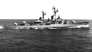
USS Edson (DD-946) is a Forrest Sherman-class destroyer, formerly of the United States Navy, built by Bath Iron Works in Maine in 1958. Her home port was Long Beach, California and she initially served in the Western Pacific/Far East, operating particularly in the Taiwan Strait and off the coast of Vietnam. Her exceptionally meritorious service in 1964 in the Gulf of Tonkin was recognized with the first of three Navy Unit Commendations. During the following years she was shelled by North Vietnamese land forces, and apparently received friendly fire from the US Air Force.

Fort Ancient is a Native American earthworks complex located in Washington Township, Warren County, Ohio, along the eastern shore of the Little Miami River about seven miles (11 km) southeast of Lebanon on State Route 350. The site is the largest prehistoric hilltop enclosure in the United States with three and one-half miles (18,000 ft) of walls in a 100-acre (0.40 km2) complex. Built by the Hopewell culture, who lived in the area from the 200 BC to AD 400, the site is situated on a wooded bluff 270 feet (82 m) above the Little Miami. It is the namesake of a culture known as Fort Ancient who lived near the complex long after it was constructed.
The Battle of Hubbardton was an engagement in the Saratoga campaign of the American Revolutionary War fought in the village of Hubbardton, Vermont. Vermont was then a disputed territory sometimes called the New Hampshire Grants, claimed by New York, New Hampshire, and the newly organized and not yet recognized but de facto independent government of Vermont. On the morning of July 7, 1777, British forces, under General Simon Fraser, caught up with the American rear guard of the forces retreating after the withdrawal from Fort Ticonderoga. It was the only battle in Vermont during the revolution.
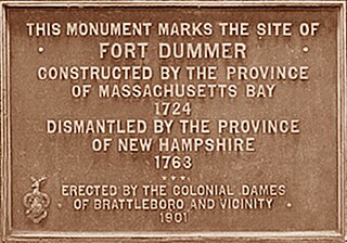
Fort Dummer was a British fort built in 1724 during Dummer's War by the colonial militia of the Province of Massachusetts Bay under the command of Lieutenant Timothy Dwight in what is now the Town of Brattleboro in southeastern Vermont. The fort was the first permanent European settlement in Vermont. It consisted of a 180-square foot wooden stockade near 42.8309°N 72.5504°W, with 12 guns manned by 55 men. Near the former site of the fort is a granite monument one mile (2 km) south of the Brattleboro railway station.
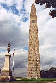
The Bennington Battle Monument is a 301-or-306-foot-high stone obelisk located at 15 Monument Circle, in Bennington, Vermont, United States. The monument commemorates the Battle of Bennington during the American Revolutionary War.
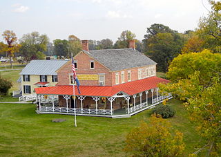
Chimney Point is a peninsula in the town of Addison, Vermont, which juts into Lake Champlain forming a narrows. It is one of the earliest settled and most strategic sites in the Champlain Valley.

Crown Point State Historic Site is the site of a former military stronghold at the south end of the wider part of Lake Champlain. The location is in Essex County, New York, United States. The site is on a peninsula in the town of Crown Point, New York.

Fort Chambly is a historic fort in La Vallée-du-Richelieu Regional County Municipality, Quebec. The fort is designated as a National Historic Site of Canada. Fort Richelieu was part of a series of five forts built along the Richelieu River. Fort Richelieu is at the mouth of the Richelieu River. Fort Chambly formerly known as Fort St. Louis at Chambly, Fort Sainte Thérèse, and Fort Saint-Jean at Saint-Jean-sur-Richelieu, are on the way. Fort Sainte Anne in Lake Champlain is near its source. The forts were built in order to protect travellers on the river from the Iroquois. The region is informally known as la Vallée-des-Forts.
"Fort Independence" is an infrequently used and incorrect alternative name for the extensive Revolutionary War fortifications located on Mount Independence in Orwell, Vermont. Although "Fort Independence" can be found occasionally in Revolutionary War documents referring to the fortifications on Lake Champlain, the proper and official name of the peninsula and fortifications was Mount Independence. During the American Revolution, "Fort Independence" nearly always refers to a fort in the Boston Harbor or one in Bronx County, New York.

Fort Richelieu is a historic fort in La Vallée-du-Richelieu Regional County Municipality, Quebec, Canada. The fort is designated as a National Historic Site of Canada. Fort Richelieu was part of a series of five forts built along the Richelieu River and is at the mouth of the Richelieu River. Fort Chambly formerly known as Fort St. Louis at Chambly, Fort Sainte-Thérèse, and Fort Saint-Jean at Saint-Jean-sur-Richelieu, are on the way. Fort Sainte Anne (Vermont) on Isle La Motte, Vermont in Lake Champlain is near its source. The forts were built in order to protect travellers on the river from the Iroquois. The region is informally known as la Vallée-des-Forts.

Mount Defiance is an 853 ft (260 m) high hill on the New York side of Lake Champlain, in the northeastern United States. It is notable in that the hill militarily dominates both Fort Ticonderoga and Mount Independence, but it was deemed inaccessible so never fortified. Mount Defiance was previously known as Sugar Loaf.
Neshobe Island is an island in Lake Bomoseen in the town of Castleton, U.S. state of Vermont. It is particularly known for its association during the 1920s and 1930s with the Algonquin Round Table, a group of literary figures.

Silver Bay is a hamlet in the town of Hague in Warren County, New York, United States. It lies on a small bay on Lake George and is the site of a YMCA conference center. The conference center is one of only a few of its type in the United States and is host to many large groups throughout the year. The center was started in 1900 and has grown ever since. Notable structures include the historic Hepbron Hall, built in 1901, a sprawling Victorian Mansion built in 1895 called Paine Hall, a 700 person auditorium built in 1909, Helen Hughes Chapel, built in 1923, Fisher Gymnasium (1917) and the Boathouse. Many of the buildings are excellent examples of Adirondack architecture. There is also a traditional-style Ice Creme Parlor open during the spring, summer, and fall. The Silver Bay Association Complex was listed on the National Register of Historic Places in 1980.

The Castleton Jail is an exhibit building located at the Shelburne Museum in Shelburne, Vermont, USA. Constructed entirely of slate, it was originally built in 1890 in Castleton, Vermont, where it operated for over fifty years.

Castleton is an Amtrak intercity train station in Castleton, Vermont. Originally built by the Rutland and Whitehall Railroad in 1850, the depot is now privately owned, and is located across from the northern terminus of the Delaware and Hudson Rail Trail. Castleton replaced Fair Haven station on the Ethan Allen Express in January 2010. It serves nearby Castleton University and Lake Bomoseen.

Castleton is a hamlet in the town of Castleton, Rutland County, Vermont. Its population is approximately 4,000. A large portion of the village is part of the Castleton Village Historic District, listed on the National Register of Historic Places in 1979. It is also home to Castleton University, founded in 1787, and now part of the Vermont State Colleges system.
Rose Lake is a lake in Martin County, in the U.S. state of Minnesota.


