
Cape Elizabeth is a town in Cumberland County, Maine, United States. The town is part of the Portland–South Portland–Biddeford, Maine, metropolitan statistical area. As of the 2010 census, Cape Elizabeth had a population of 9,015.

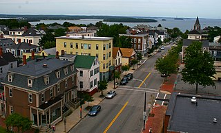
South Portland is a city in Cumberland County, Maine, United States, and is the fourth-largest city in the state, incorporated in 1898. As of the 2010 census, the city population was 25,002. Known for its working waterfront, South Portland is situated on Portland Harbor and overlooks the skyline of Portland and the islands of Casco Bay. Due to South Portland's close proximity to air, marine, rail, and highway transportation options, the city has become a center for retail and industry in the region.

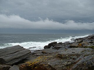
Casco Bay is an inlet of the Gulf of Maine on the southern coast of Maine, New England, United States. Its easternmost approach is Cape Small and its westernmost approach is Two Lights in Cape Elizabeth. The city of Portland sits along its southern edge and the Port of Portland lies within.
Portland Head Light, is a historic lighthouse in Cape Elizabeth, Maine. The light station sits on a head of land at the entrance of the primary shipping channel into Portland Harbor, which is within Casco Bay in the Gulf of Maine. Completed in 1791, it is the oldest lighthouse in the state of Maine. The light station is automated, and the tower, beacon, and foghorn are maintained by the United States Coast Guard, while the former lighthouse keepers' house is a maritime museum within Fort Williams Park.

Fort Knox, now Fort Knox State Park or Fort Knox State Historic Site, is located on the western bank of the Penobscot River in the town of Prospect, Maine, about 5 miles (8.0 km) from the mouth of the river. Built between 1844 and 1869, it was the first fort in Maine built entirely of granite; most previous forts used wood, earth, and stone. It is named after Major General Henry Knox, the first U.S. Secretary of War and Commander of Artillery during the American Revolutionary War, who at the end of his life lived not far away in Thomaston. As a virtually intact example of a mid-19th century granite coastal fortification, it was added to the National Register of Historic Places in 1969 and declared a National Historic Landmark on December 30, 1970. Fort Knox also serves as the entry site for the observation tower of the Penobscot Narrows Bridge that opened to the public in 2007.

Fort Edgecomb, built in 1808–1809, is a two-story octagonal wooden blockhouse with restored fortifications located on Davis Island in the town of Edgecomb, Lincoln County, Maine, United States. It is the centerpiece of the Fort Edgecomb State Historic Site. It was added to the National Register of Historic Places in 1969, with its boundaries increased to create a historic district in 1991.

The Beach to Beacon 10K is a 10-kilometer (6.2 mi) road running event that takes place along the coastline of Cape Elizabeth, Maine. It begins at Crescent Beach State Park and ends at the Portland Head Light in Fort Williams Park.
Fort Frederick may refer to:

Fort Gorges is a former United States military fort built on Hog Island Ledge in Casco Bay, Maine. Built from 1858 to 1864, no battles were fought there and no troops were stationed there. Advancing military technology, including iron clad ships and long range guns, made the fort obsolete before it could be used. The fort is now a park, accessible only by boat. It was added to the National Register of Historic Places in 1973.
Munjoy Hill is a neighborhood and prominent geographical feature of Portland, Maine. It is located east of downtown and south of East Deering, the neighborhood it is connected to by Tukey's Bridge. The neighborhood historically had a large Irish and Italian American population.

Battery Garesche or Battery Garesché was a Union Army artillery battery built as part of the defenses of Washington, D.C. in the American Civil War at what is now Abingdon Street at South 30th Road in Fairlington, Arlington County, Virginia.

Fort Popham is a Civil War-era coastal defense fortification at the mouth of the Kennebec River in Phippsburg, Maine. It is located in sight of the short-lived Popham Colony and, like the colony, named for George Popham, the colony's leader.

Fort O'Brien State Historic Site, also known as Fort Machias, preserves the remains of a fort located in Machiasport, Maine that was built and destroyed three times over a 90-year period. It was involved in military actions during the American Revolutionary War and the War of 1812, and was listed on the National Register of Historic Places. It is now managed by the Maine Department of Conservation's Bureau of Parks and Lands, and is open between Memorial Day and Labor Day.
Two Lights State Park is a public recreation area occupying 41 acres (17 ha) of headland on Cape Elizabeth, Maine, that offers views of Casco Bay and the Atlantic Ocean. The state park, which opened in 1961, is named after the twin Cape Elizabeth Lights, although there are no lighthouses in the park itself. In addition to rocky headlands, the park includes the remains of a World War II–era seacoast battery bunker and a fire control tower. It is managed by the Maine Department of Agriculture, Conservation and Forestry.

The Eastern Promenade is a historic promenade, 68.2-acre (27.6 ha) public park and recreation area in Portland, Maine. Construction of the Promenade began in 1836 and continued periodically until 1934. The 1.5-mile (2.4 km) park was designed by the Olmsted Brothers design firm and experienced its greatest expansion from the 1880s to the 1910s. The Promenade rings around the Munjoy Hill neighborhood and occupies the farthest eastern portion of Portland's peninsula. The Promenade is home to many historical sites, including a mass grave and the mast of USS Portland.

Battery Steele is a United States military fortification on Peaks Island, Portland, Maine in Casco Bay. Completed in 1942 as part of World War II, it is located on 14 acres (5.7 ha) on the oceanside area of the island, formerly part of the Peaks Island Military Reservation. It is named for Harry Lee Steele, who was a Coast Artillery officer during World War I. It was armed with two 16-inch MkIIMI guns and, with a 12-inch gun battery at Fort Levett on Cushing Island, replaced all previous heavy guns in the Harbor Defenses of Portland. It was built to protect Casco Bay, particularly Portland harbor, from Kennebunk to Popham Beach in Phippsburg. According to Kim MacIsaac and historian Joel Eastman in An Island at War, “Battery Steele is not only the largest gun battery built on Peaks Island, but also an example of the largest battery ever built anywhere in the United States.” In 1995, after decades of non-use, the Peaks Island Land Preserve, a community land preservation group, formed to purchase the area and forever preserve it as a public space. On October 20, 2005, the property was listed on the National Register of Historic Places. Other coast defense structures on the island include fire control towers and the counterweight for a disappearing searchlight tower.

Fort Sumner was a coastal defense fortification on Munjoy Hill in Portland, Maine, United States. It was built in 1794 as part of the First System of coastal fortifications built by the United States. It was reportedly originally named Fort Allen after the nearby Revolutionary War battery that probably became part of Fort Sumner, but was renamed in 1797 after Increase Sumner, the incumbent Governor of Massachusetts, of which Maine was then a part. The location is now Fort Sumner Park, also called Standpipe Park, at 60 North Street.

The Harbor Defenses of Portland was a United States Army Coast Artillery Corps harbor defense command. It coordinated the coast defenses of Portland, Maine, the mouth of the Kennebec River, and surrounding areas from 1895 to 1950, beginning with the Endicott program. These included both coast artillery forts and underwater minefields. The command originated circa 1895 as the Portland Artillery District, was renamed Coast Defenses of Portland in 1913, and again renamed Harbor Defenses of Portland in 1925.


