Fort Williams (Virginia)

Last updated
Fort Williams
Part of the Civil War defenses of Washington, D.C.
Alexandria, Virginia
FortWilliamsHistoricalSite.png
Fort Williams located in the backyard of 212 Quaker Lane in Alexandria, Virginia
Coordinates 38°48′42″N77°05′24″W / 38.81180°N 77.09000°W / 38.81180; -77.09000
TypeEarthwork fort
Site information
Controlled by Union Army
ConditionDismantled
Site history
Built1861
Built by U.S. Army Corps of Engineers
In use1861–1865
MaterialsEarth, timber
Demolished1865
Battles/wars American Civil War

Fort Williams was a timber and earthwork fortification constructed in Alexandria, Virginia as part of the defenses of Washington, D.C. during the American Civil War.

Contents

History

Fort Williams was named for Thomas Williams who was killed at Baton Rouge on August 5, 1862.

Built in the weeks following the Union defeat at Bull Run, Fort Williams was situated on north of Hunting Creek and Cameron Run, (which feeds into it), near Vaucluse. From its position on Quaker Lane, one of the points west of Alexandria, the fort overlooked the Orange and Alexandria Railroad, the Little River Turnpike, and the western approaches to the city of Alexandria which is the largest settlement in Union-occupied Northern Virginia.

Built by the 2nd Connecticut Heavy Artillery Regiment, Fort Williams had a perimeter of 250 yards, and space for 13 guns. [1]

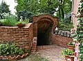
The Fort is now located in the backyard of a property in the Seminary Ridge neighborhood. [2] Portions are also included in a 7.80 acres (31,600 m2) Alexandria, Virginia city park, at 501 Fort Williams Parkway. [3] A small cemetery with the gravesites of several Union soldiers was located in the woods off the southeast corner of Seminary Road and Fort Williams Parkway. The graves were not well known and were desecrated when homes were built on that plot in the mid-1980s.

Among those stationed at the fort during the war was George Tryon Harding, father of Warren G. Harding, who spent time there in 1864. [4]

Related Research Articles

<span class="mw-page-title-main">George Washington Memorial Parkway</span> 7,142-acre parkway maintained by the National Park Service

The George Washington Memorial Parkway, colloquially the G.W. Parkway, is a 25-mile-long (40 km) parkway that runs along the south bank of the Potomac River from Mount Vernon, Virginia, northwest to McLean, Virginia, and is maintained by the National Park Service (NPS). It is located almost entirely within Virginia, except for a short portion of the parkway northwest of the Arlington Memorial Bridge that passes over Columbia Island within the District of Columbia.

<span class="mw-page-title-main">Fort Marcy (Virginia)</span>

Fort Marcy was a Union fortification protecting Washington, D.C. during the American Civil War. Its remains are now administered by the National Park Service as part of the George Washington Memorial Parkway in Fairfax County, Virginia.

<span class="mw-page-title-main">Fort Ethan Allen (Arlington, Virginia)</span> United States historic place

Fort Ethan Allen was an earthwork fortification that the Union Army built in 1861 on the property of Gilbert Vanderwerken in Alexandria County, Virginia, as part of the Civil War defenses of Washington. The remains of the fort are now within Arlington County's Fort Ethan Allen Park.

<span class="mw-page-title-main">Fort Scott (Arlington, Virginia)</span> Historical fort in Arlington, Virginia, United States

Fort Scott was a detached lunette constructed in May 1861 to guard the south flank of the defenses of Washington during the American Civil War. It was named for General Winfield Scott, who was then General-in-Chief of the Union Army. An historic marker and a small remnant of the fort are the only evidence of the site of the fort on the grounds of what is now Fort Scott Park in Arlington County, Virginia.

<span class="mw-page-title-main">Fort Ward (Virginia)</span> United States historic place

Fort Ward is a former Union Army installation now located in the city of Alexandria in the U.S. state of Virginia. It was the fifth largest fort built to defend Washington, D.C. in the American Civil War. It is currently well-preserved with 90-95% of its earthen walls intact.

<span class="mw-page-title-main">Battery Garesche</span>

Battery Garesche or Battery Garesché was a Union Army artillery battery built as part of the defenses of Washington, D.C. in the American Civil War at what is now Abingdon Street at South 30th Road in Fairlington, Arlington County, Virginia.

<span class="mw-page-title-main">Fort Reynolds (Virginia)</span>

Fort Reynolds was a Union Army redoubt built as part of the defenses of Washington, D.C., in the American Civil War.

<span class="mw-page-title-main">Arlington Line</span> Union Army fortifications around Washington, D.C. during the Civil War (1860s)

The Arlington Line was a series of fortifications that the Union Army erected in Alexandria County, Virginia, to protect the City of Washington during the American Civil War.

<span class="mw-page-title-main">Battery Rodgers</span>

Battery Rodgers was a gun emplacement that composed a portion of the American Civil War defenses of the American capital city of Washington, D.C.

<span class="mw-page-title-main">Fort C. F. Smith (Arlington, Virginia)</span> Archaeological site in Virginia, United States

Fort C.F. Smith was a lunette that the Union Army constructed in Alexandria County, Virginia, during 1863 as part of the Civil War defenses of Washington. It was named in honor of General Charles Ferguson Smith, who died from a leg infection that was aggravated by dysentery on April 25, 1862. Fort C. F. Smith connected the Potomac River to the Arlington Line, a row of fortifications south of Washington, D.C., that was intended to protect the capital of the United States from an invasion by the Confederate States Army.

<span class="mw-page-title-main">Fort Runyon</span> Historical fort in Arlington, Virginia, United States

Fort Runyon was a timber and earthwork fort constructed by the Union Army following the occupation of northern Virginia in the American Civil War in order to defend the southern approaches to the Long Bridge as part of the defenses of Washington, D.C. during that war. The Columbia Turnpike and Alexandria and Loudon Railroad ran through the pentagonal structure, which controlled access to Washington via the Long Bridge. With a perimeter of almost 1,500 yards (1,400 m), and due to its unusual shape it was approximately the same size, shape, and in almost the same location as the Pentagon, built 80 years later.

<span class="mw-page-title-main">Fort Jackson (Virginia)</span> Historical fort in Virginia

Fort Jackson was an American Civil War-era fortification in Virginia that defended the southern end of the Long Bridge, near Washington, D.C. Long Bridge connected Washington, D.C. to Northern Virginia and served as a vital transportation artery for the Union Army during the war. Fort Jackson was named for Jackson City, a seedy suburb of Washington that had been established on the south side of the Long Bridge in 1835. It was built in the days immediately following the Union Army's occupation of Northern Virginia in May 1861. The fort was initially armed with four cannon used to protect the bridge, but these were removed after the completion of the Arlington Line, a line of defenses built to the south. After 1862, the fort lacked weapons except for small arms and consisted of a wooden palisade backed by earthworks. Two cannon were restored to the fort in 1864 following the Battle of Fort Stevens. The garrison consisted of a single company of Union soldiers who inspected traffic crossing the bridge and guarded it from potential saboteurs.

<span class="mw-page-title-main">Fort Lyon (Virginia)</span> Historic fort in Virginia, USA

Fort Lyon was a timber and earthwork fortification constructed south of Alexandria, Virginia as part of the defenses of Washington, D.C. during the American Civil War. Built in the weeks following the Union defeat at Bull Run, Fort Lyon was situated on Ballenger's Hill south of Hunting Creek, and Cameron Run, near Mount Eagle. From its position on one of the highest points south of Alexandria, the fort overlooked Telegraph Road, the Columbia Turnpike, the Orange and Alexandria Railroad, the Little River Turnpike, and the southern approaches to the city of Alexandria, the largest settlement in Union-occupied Northern Virginia.

<span class="mw-page-title-main">Alexandria, Virginia</span> Independent city in Virginia, United States

Alexandria is an independent city in the northern region of the Commonwealth of Virginia, United States. It lies on the western bank of the Potomac River approximately 7 miles (11 km) south of downtown Washington, D.C. Alexandria is the third largest "principal city" of the Washington metropolitan area which is part of the larger Washington-Baltimore combined statistical area.

Fort Worth was a timber and earthwork fortification constructed west of Alexandria, Virginia as part of the defenses of Washington, D.C. during the American Civil War.

<span class="mw-page-title-main">Fort Ellsworth</span>

Fort Ellsworth was a timber and earthwork fortification constructed west of Alexandria, Virginia, as part of the defenses of Washington, D.C. during the American Civil War. Built in the weeks following the Union defeat at Bull Run, Fort Ellsworth was situated on a hill north of Hunting Creek, and Cameron Run,. From its position on one of the highest points west of Alexandria, the fort overlooked the Orange and Alexandria Railroad, the Little River Turnpike, and the southern approaches to the city of Alexandria, the largest settlement in Union-occupied Northern Virginia.

<span class="mw-page-title-main">Fort Willard</span>

Fort Willard is a former Union Army installation now located in the Belle Haven area of Fairfax County in the U.S. state of Virginia. It is currently undergoing preservation treatment to protect its earthen walls and trenches.

Fort O'Rourke is a former Union Army installation now located in the Belle Haven area of Fairfax County in the U.S. state of Virginia. It was the southernmost fort built to defend Washington, D.C. in the American Civil War.

Shepherd Parkway is part of the Civil War Defenses of Washington. It includes two forts, of which some remains still exist. The parkway runs along the high ground opposite the Anacostia Freeway from Joint Base Anacostia–Bolling in the District of Columbia. Shepherd Parkway is bordered on the north by St. Elizabeths Campus and the District of Columbia neighborhoods of Congress Heights and Bellevue and on the south by Bald Eagle Hill.

<span class="mw-page-title-main">Fort Farnsworth</span>

Fort Farnsworth is a former Union Army installation now located in the Huntington area of Fairfax County, Virginia. It was a timber and earthwork fortification constructed south of Alexandria, Virginia as part of the defenses of Washington, D.C. during the American Civil War. Nothing survives of the fort's structure as the Huntington Station of the Washington Metro occupies Fort Farnsworth's former hilltop site.

References

  1. Cooling III, Benjamin Franklin; Owen II, Walton H. (6 October 2009). Mr. Lincoln's Forts: A Guide to the Civil War Defenses of Washington. Scarecrow Press. pp. 64–70. ISBN   978-0-8108-6307-1.
  2. oldtowncrier (1 March 2017). "Traitor's Hill" . Retrieved 26 July 2017.
  3. Parks E-H | Recreation | City of Alexandria, VA
  4. Young, Jeff C. (1997). The Fathers of American Presidents: from Augustine Washington to William Blythe and Roger Clinton. Jefferson NC McFarland & Co. p.  143. ISBN   0786401826.