Fort Myer is the previous name used for a U.S. Army post next to Arlington National Cemetery in Arlington County, Virginia, and across the Potomac River from Washington, D.C. Founded during the American Civil War as Fort Cass and Fort Whipple, the post merged in 2005 with the neighboring Marine Corps installation, Henderson Hall, and is today named Joint Base Myer–Henderson Hall.
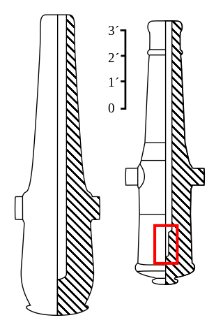
The Rodman gun is any of a series of American Civil War–era columbiads designed by Union artilleryman Thomas Jackson Rodman (1815–1871). The guns were designed to fire both shot and shell. These heavy guns were intended to be mounted in seacoast fortifications. They were built in 8-inch, 10-inch, 13-inch, 15-inch, and 20-inch bore. Other than size, the guns were all nearly identical in design, with a curving bottle shape, large flat cascabels with ratchets or sockets for the elevating mechanism. Rodman guns were true guns that did not have a howitzer-like powder chamber, as did many earlier columbiads. Rodman guns differed from all previous artillery because they were hollow cast, a new technology that Rodman developed that resulted in cast-iron guns that were much stronger than their predecessors.
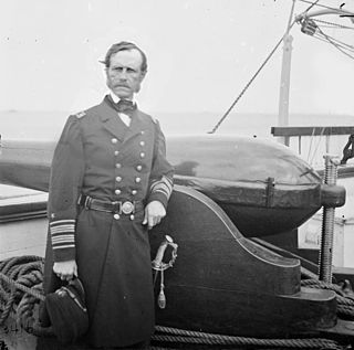
Dahlgren guns were muzzle-loading naval artillery designed by Rear Admiral John A. Dahlgren USN, mostly used in the period of the American Civil War. Dahlgren's design philosophy evolved from an accidental explosion in 1849 of a 32 lb (14.5 kg) gun being tested for accuracy, killing a gunner. He believed a safer, more powerful naval cannon could be designed using more scientific design criteria. Dahlgren guns were designed with a smooth curved shape, equalizing strain and concentrating more weight of metal in the gun breech where the greatest pressure of expanding propellant gases needed to be met to keep the gun from bursting. Because of their rounded contours, Dahlgren guns were nicknamed "soda bottles", a shape which became their most identifiable characteristic.

Fort Ethan Allen was an earthwork fortification that the Union Army built in 1861 on the property of Gilbert Vanderwerken in Alexandria County, Virginia, as part of the Civil War defenses of Washington. The remains of the fort are now within Arlington County's Fort Ethan Allen Park.
Fort Albany was a bastioned earthwork that the Union Army built in Arlington County in Virginia. The Army constructed the fort during May 1861 as part of its Civil War defenses of Washington.

Fort Richardson was a detached redoubt that the Union Army constructed in September 1861 as part of the Civil War defenses of Washington. The Army built the fort shortly after its rout at the First Battle of Bull Run (Manassas) in late July 1861. The Army named the fort after General Israel B. Richardson, whose division had been deployed to defend the City of Washington against attack by way of the Columbia Turnpike.

Fort Bunker Hill was one of seven temporary earthwork forts part of the Civil War Defenses of Washington, D.C., during the Civil War built in the Northeast quadrant of the city at the beginning of the Civil War by the Union Army to protect the city from the Confederate Army. From west to east, the forts were: Fort Slocum, Fort Totten, Fort Slemmer, Fort Bunker Hill, Fort Saratoga, Fort Thayer and Fort Lincoln. Unlike other forts, today very little remains of the structure.

Battery Rodgers was a gun emplacement that composed a portion of the American Civil War defenses of the American capital city of Washington, D.C.

Fort C.F. Smith was a lunette that the Union Army constructed in Alexandria County, Virginia, during 1863 as part of the Civil War defenses of Washington. It was named in honor of General Charles Ferguson Smith, who died from a leg infection that was aggravated by dysentery on April 25, 1862. Fort C. F. Smith connected the Potomac River to the Arlington Line, a row of fortifications south of Washington, D.C., that was intended to protect the capital of the United States from an invasion by the Confederate States Army.

Fort Stanton was a Civil War-era fortification constructed in the hills above Anacostia in the District of Columbia, USA, and was intended to prevent Confederate artillery from threatening the Washington Navy Yard. It also guarded the approach to the bridge that connected Anacostia with Washington. Built in 1861, the fort was expanded throughout the war and was joined by two subsidiary forts: Fort Ricketts and Fort Snyder. Following the surrender of the Army of Northern Virginia, it was dismantled and the land returned to its original owner. It never saw combat. Abandoned after the war, the site of the fort was planned to be part of a grand "Fort Circle" park system encircling the city of Washington. Though this system of interconnected parks never was fully implemented, the site of the fort is today a park maintained by the National Park Service, and a historical marker stands near the fort's original location.

Fort Bayard was an earthwork fort constructed in 1861 northwest of Tenleytown in the District of Columbia as part of the defenses of Washington, D.C., during the American Civil War. It never faced major opposition during the conflict and was decommissioned following the surrender of Robert E. Lee's Army of Northern Virginia. Named after Brigadier General George Dashiell Bayard, who was killed at the Battle of Fredericksburg, the site of the fort is in Boundary Park, located at the intersection of River Road and Western Avenue NW in Washington, D.C., and is maintained by the U.S. National Park Service. No trace of the fort remains, though a marker commemorating its existence has been erected by the Park Service.

Fort Corcoran was a wood-and-earthwork fortification constructed by the Union Army in northern Virginia as part of the defenses of Washington, D.C. during the American Civil War. Built in 1861, shortly after the occupation of Arlington, Virginia by Union forces, it protected the southern end of the Aqueduct Bridge and overlooked the Potomac River and Theodore Roosevelt Island, known as Mason's Island.

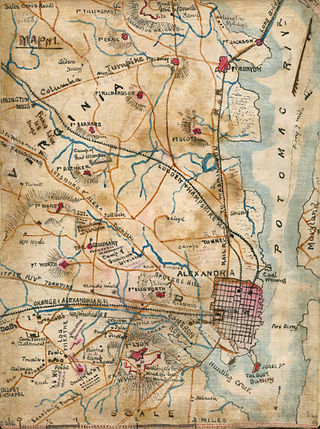
Fort Runyon was a timber and earthwork fort constructed by the Union Army following the occupation of northern Virginia in the American Civil War in order to defend the southern approaches to the Long Bridge as part of the defenses of Washington, D.C. during that war. The Columbia Turnpike and Alexandria and Loudon Railroad ran through the pentagonal structure, which controlled access to Washington via the Long Bridge. With a perimeter of almost 1,500 yards (1,400 m), and due to its unusual shape it was approximately the same size, shape, and in almost the same location as the Pentagon, built 80 years later.

Fort Lyon was a timber and earthwork fortification constructed south of Alexandria, Virginia as part of the defenses of Washington, D.C. during the American Civil War. Built in the weeks following the Union defeat at Bull Run, Fort Lyon was situated on Ballenger's Hill south of Hunting Creek, and Cameron Run, near Mount Eagle. From its position on one of the highest points south of Alexandria, the fort overlooked Telegraph Road, the Columbia Turnpike, the Orange and Alexandria Railroad, the Little River Turnpike, and the southern approaches to the city of Alexandria, the largest settlement in Union-occupied Northern Virginia.

Fort Willard is a former Union Army installation now located in the Belle Haven area of Fairfax County in the U.S. state of Virginia. It is currently undergoing preservation treatment to protect its earthen walls and trenches.

Battery Kemble Park is a park in Northwest Washington D.C., administered by the National Park Service.

Fort Craig was a small lunette that the Union Army constructed in September 1861 in Arlington County in Virginia during the American Civil War. The lunette was part of the Civil War defenses of Washington.
Fort Tillinghast was a small lunette that the Union Army constructed in Alexandria County, Virginia, as part of the Civil War defenses of Washington. Fort Tillinghast stood about 0.6 miles away from Arlington House, the Union-occupied estate of Confederate General Robert E. Lee.

Fort Lincoln was one of seven temporary earthwork forts part of the Civil War Defenses of Washington, DC during the Civil War built in the Northeast quadrant of the city at the beginning of the Civil War by the Union Army to protect the city from the Confederate Army. From west to east, the forts were as follow: Fort Slocum, Fort Totten, Fort Slemmer, Fort Bunker Hill, Fort Saratoga, Fort Thayer and Fort Lincoln.

Fort Slocum was one of seven temporary earthwork forts, part of the Civil War Defenses of Washington, D.C., during the Civil War, built in the Northeast quadrant of the city after the beginning of the war by the Union Army to protect the city from the Confederate Army. From west to east, the forts were as follow: Fort Slocum, Fort Totten, Fort Slemmer, Fort Bunker Hill, Fort Saratoga, Fort Thayer and Fort Lincoln.


