Fort Bayard (Washington, D.C.)

Last updated
Fort Bayard
Part of the Civil War defenses of Washington, D.C.
District of Columbia
Fort Bayard Map.tif
Map of the fort
Coordinates 38°57′23″N77°05′28″W / 38.95639°N 77.09111°W / 38.95639; -77.09111 Coordinates: 38°57′23″N77°05′28″W / 38.95639°N 77.09111°W / 38.95639; -77.09111
TypeEarthwork fort
Site information
Owner U.S. National Park Service
Controlled by Union Army
Open to
the public
Yes
ConditionPublic park
Site history
Built1861
Built by U.S. Army Corps of Engineers
In use1861–1865
MaterialsEarth, timber
Demolished1865
Battles/wars American Civil War

Fort Bayard was an earthwork fort constructed in 1861 northwest of Tenleytown in the District of Columbia as part of the defenses of Washington, D.C., during the American Civil War. It never faced major opposition during the conflict and was decommissioned following the surrender of Robert E. Lee's Army of Northern Virginia. Named after Brigadier General George Dashiell Bayard, who was killed at the Battle of Fredericksburg, the site of the fort is in Boundary Park, located at the intersection of River Road and Western Avenue NW in Washington, D.C., and is maintained by the U.S. National Park Service. No trace of the fort remains, though a marker commemorating its existence has been erected by the Park Service.

Contents

Pre-war use

Prior to the outbreak of the Civil War, the District of Columbia was a predominantly rural area. Though the city of Washington is today synonymous with the District of Columbia, in 1861, Washington occupied only a portion of the District. The remaining portions of the District were considered part of Washington County, and it was in this region that most of the forts defending Washington, including Fort Bayard, were constructed. Washington County was characterized as "the rural part of the district ... occupied by farms of various sizes and the grand estates of the well-to-do." [1]

The site of Fort Bayard itself was owned by Philip J. Buckey, a farmer who made his home in the Fourth Ward of Washington County. During the construction process, he valued the land at approximately $5,000, and continued to live in a farmhouse near the fort with his wife, four children, and two servants throughout the course of the war. [2] In exchange for the use of his land for the site of Fort Bayard, Buckey received $50.00 per year in rent from the War Department. [3]

Also nearby was the Shoemaker family, which owned substantial tracts of land in both the District and in Maryland. Three forts or portions of forts were built on their property: Fort Simmons, Fort Mansfield, and Battery Bailey. Despite the loss of much of their land, the Shoemaker family continued to operate a local general store and sold various sundry items to the garrison at Fort Bayard. [4]

Planning and construction

Following the secession of Virginia and that state joining the Confederacy, Federal troops marched from Washington into the Arlington region of northern Virginia. The move was intended to forestall any attempt by Virginia militia or Confederate States Army to seize the capital city of the United States. Over the next seven weeks, forts were constructed along the banks of the Potomac River and at the approaches to each of the three major bridges (Chain Bridge, Long Bridge, and Aqueduct Bridge) connecting Virginia to Washington and Georgetown. [5]

While the Potomac River forts were being built, planning and surveying was ordered for an enormous new ring of forts to protect the city. Unlike the fortifications under construction, the new forts would defend the city in all directions, not just the most direct route through Arlington. In mid-July, this work was interrupted by the First Battle of Bull Run. As the Army of Northeastern Virginia marched south to Manassas, the soldiers previously assigned to construction duties marched instead to battle. In the days that followed the Union defeat at Bull Run, panicked efforts were made to defend Washington from what was perceived as an imminent Confederate attack. [6] The makeshift trenches and earthworks that resulted were largely confined to Arlington and the direct approaches to Washington.

On July 26, 1861, five days after the battle, Maj. Gen. George B. McClellan was named commander of the military district of Washington and the subsequently renamed Army of the Potomac. Upon arriving in Washington, McClellan was appalled by the condition of the city's defenses. "In no quarter were the dispositions for defense such as to offer a vigorous resistance to a respectable body of the enemy, either in the position and numbers of the troops or the number and character of the defensive works... not a single defensive work had been commenced on the Maryland side. There was nothing to prevent the enemy shelling the city from heights within easy range, which could be occupied by a hostile column almost without resistance." [7]

To remedy the situation, one of McClellan's first orders upon taking command was to greatly expand the defenses of Washington. At all points of the compass, forts and entrenchments would be constructed in sufficient strength to slow an attack and buy time for reinforcements to arrive and bolster the city's defenses. Brigadier General John G. Barnard, was named chief engineer of the Department of Washington, and would supervise the construction and maintenance of the forts before being named chief engineer of the armies in the field by Ulysses S. Grant in 1864. [8]

The location of Fort Bayard northwest of Tenleytown and Fort Reno in the District of Columbia. The line bisecting the fort is the border between the District of Columbia and Maryland. Fort Bayard Crop.jpg
The location of Fort Bayard northwest of Tenleytown and Fort Reno in the District of Columbia. The line bisecting the fort is the border between the District of Columbia and Maryland.

Prior to the outbreak of war, the Great Falls Turnpike, also known as River Road, was an important traffic artery for trade entering the District of Columbia from western Maryland and beyond. It connected the village of Tenleytown with the city of Washington, and roughly paralleled the Potomac River before turning northward. Due to its strategic position along the river, which formed the border between the Confederate state of Virginia and the Union state of Maryland, it had great military value and was a likely route for an attacking army, as would be proved three years after the outbreak of war during the Battle of Fort Stevens. [9]

To prevent a Confederate force from advancing on Washington along the Potomac, several forts were constructed on hills near the river. To guard River Road, which was the most direct route into the city, U.S. Army engineers built a small, round fort at the point where River Road crossed into the district of Columbia. With a perimeter of only 123 yards and mounting only six guns, it was located forward of Fort Reno, the largest fort protecting the Tenleytown area. [10] Details of the actual construction process are scarce, though a letter from a member of the Ninth New York Heavy Artillery regiment to the Democratic Press newspaper indicates that the fort was at least partially built with labor from that regiment. [11]

In April 1863, the fort was named in honor of the recently deceased Brigadier General George Dashiell Bayard, who had been killed on December 13, 1862, at the Battle of Fredericksburg. [12] At the time of its dedication, the fort was roughly complete. Round in shape and surrounded by trenches and abati, the fort's guns faced north, overlooking River Road. A service road crossed the trenches in the southern half of the fort, connecting with River Road behind the fort. Rifle pits extended northeast to Fort Reno and southwest to Fort Simmons. [13] A small battery of guns, named Battery Bayard, was an outwork of the fort and covered a blind spot in the ravine to the northwest of the fort. [10]

Wartime use

Brigadier General George Dashiell Bayard GDBayard.jpg
Brigadier General George Dashiell Bayard

In accordance to a plan laid out in an October 1861 report by General John G. Barnard, "rear line" forts were to receive one man per yard of fort perimeter when fully garrisoned. Front-line forts were to receive two men per yard, when needed. However, most forts were not kept fully garrisoned at all times. [14] Due to its location north of the Potomac River, Fort Bayard was considered a rear-line fort. If the fort needed to be fully garrisoned due to an impending attack, the difference in the actual garrison and the plan would be made good from Washington's 25,000-man reserve force. As General Barnard would say in a December 24, 1862, report, "It is seldom necessary to keep these infantry supports attached to the works." [15]

However, this plan only applied to men manning the walls of the fort, not the artillerymen who would be serving the fort's guns. To man the guns of Fort Greble and those of Washington's other forts, Barnard designated three crews for each gun. These crews would be permanently located at the fort, unlike the men assigned to the walls of the fort. [16]

This plan was affected by the needs of the war. As the fighting dragged on and casualties mounted, the various commanders of the Army of the Potomac repeatedly raided the Washington garrison for trained artillerymen and infantry replacements. By 1864, Washington had been stripped to a total less than half that of Barnard's 1861 recommendation. [17]

A May 1864 report by General Albion P. Howe, inspector of artillery for the Union Army, found Fort Bayard's garrison to consist of only a single company from the Seventh New York Heavy Artillery regiment. One hundred and thirty-seven men of various ranks manned two 12-pound field howitzers and four 20-pound Parrott rifles. In addition, Howe found the fort's single magazine to be "dry and in good order," and the ammunition supply as "full and servicible." As to the garrison of the fort, Howe was less complimentary. After examining the garrison company's drill in artillery and infantry tactics, he reported the artillery drill as "ordinary; needs improving," the infantry drill as "very indifferent; needs much improving," and discipline at the fort overall was "indifferent." [18]

Artillerymen and infantry from New Hampshire, Pennsylvania, Ohio, and New York were stationed at the fort at various times during the war. [18] [19] [20] Following General Howe's unfavorable review of the Seventh New York, the garrison was replaced by a company of men from the 163rd Ohio Infantry. [21]

Battle of Fort Stevens

During the course of the war, Fort Bayard came under attack only once. During the Battle of Fort Stevens in July 1864, Confederate general Jubal Early launched a 25,000-man raid into Maryland with the hope of drawing off some of General Ulysses S. Grant's troops, who were pressing hard against the Army of Northern Virginia in the siege of Petersburg. The raid hoped to attack Washington, thereby distracting Grant and potentially allowing the Confederate forces time to rest and regroup. On the morning of July 11, Confederate cavalry and infantry under the command of Brigadier General John McCausland advanced towards Washington with the goal of capturing Fort Reno, which defended the village of Tenleytown. Though they drove back the skirmish line in front of Fort Bayard, the Confederate cavalry were met with a heavy barrage of cannon fire from Bayard and its supporting forts. Discouraged by the resistance, McCausland's brigade moved to join up with the rest of Early's force, which was grouping for an assault on Fort Stevens. [22]

Throughout the day, additional reinforcements arrived at the fort, but no further Confederate attack took place. During the remainder of the war, Fort Bayard did not fire a shot in anger.

Postwar use

After the surrender of Robert E. Lee's Army of Northern Virginia on April 9, 1865, the primary reason for manned defenses protecting Washington ceased to exist. Initial recommendations by Col. Barton S. Alexander, chief engineer of the Washington defenses, were to divide the defenses into three classes: those that should be kept active (first-class), those that should be mothballed and kept in a reserve state (second-class), and those that should be abandoned entirely (third-class). Owing to its position north of the Potomac River and to the small size of the fort, Fort Bayard fell into the third-class category, and was abandoned a few months after the end of the war. [23]

Fort Bayard Park

Fort Bayard Park Fort Bayard Park.jpg
Fort Bayard Park

The abandoned fort remained in a constantly deteriorating condition until 1919, when the Commissioners of the District of Columbia pushed Congress to pass a bill that would consolidate the sites of the aging forts into a "Fort Circle" system of parks that would ring the growing city of Washington. As envisioned by the Commissioners, the Fort Circle would be a green ring of parks outside the city, owned by the government, and connected by a "Fort Drive" road in order to allow Washington's citizens to easily escape the confines of the capital. However, the bill allowing for the purchase of the former forts, which had been turned back over to private ownership after the war, failed to pass both the House of Representatives and Senate. [24]

Despite that failure, in 1925 a similar bill passed both the House and Senate, which allowed for the creation of the National Capital Parks Commission (NCPC) to oversee the construction of a Fort Circle of parks similar to that proposed in 1919. [25] The duty of purchasing land and constructing the fort parks changed hands several times throughout the 1920s and 1930s, eventually culminating with the Department of the Interior and the National Park Service taking control of the project in the 1940s. [26] By the time the site of Fort Bayard was purchased in 1926, the remains of the fort had been demolished and homes were being built on the site. [27]

Budget cuts and the interruption of World War II repeatedly postponed the Fort Circle Park plan, but it was the growth of the city of Washington itself that eventually killed the plan. By 1963, when President John F. Kennedy began pushing Congress to finally build the Fort Circle Drive, [28] many in Washington and the National Park Service were openly questioning whether the plan had outgrown its usefulness. [29] After all, by this time, Washington had grown past the ring of forts that had protected it a century earlier, and city surface roads already connected the parks, albeit not in as linear a route as envisioned. [30] The plan to link Fort Bayard Park with other fort parks via a grand drive was quietly dropped in the years that followed.

Today, the park is bordered by Western Avenue, River Road, and Fessenden, 46th and 47th Streets, NW in Washington, D.C. It contains one softball field and one soccer field, and is maintained year-round by the U.S. National Park Service. [31] In 1999, neighborhood residents established Friends of Fort Bayard Park, Inc., a non-profit 501(c)(3) corporation with the goal of assisting the National Park Service in maintaining Fort Bayard Park. To this end, the organization hosts an annual cleanup of the park, and holds fundraisers in order to build improvements at the park. [20]

See also

Related Research Articles

Fort Ethan Allen (Arlington, Virginia) United States historic place

Fort Ethan Allen was an earthwork fortification that the Union Army built in 1861 on the property of Gilbert Vanderwerken in Alexandria County, Virginia, as part of the Civil War defenses of Washington. The remains of the fort are now within Arlington County's Fort Ethan Allen Park.

Fort Scott (Arlington, Virginia)

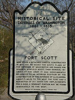
Fort Scott was a detached lunette constructed in May 1861 to guard the south flank of the defenses of Washington during the American Civil War. It was named for General Winfield Scott, who was then General-in-Chief of the Union Army. An historic marker and a small remnant of the fort are the only evidence of the site of the fort on the grounds of what is now Fort Scott Park in Arlington County, Virginia.

Fort Washington Park

Fort Washington, located near the community of Fort Washington, Maryland, was for many decades the only defensive fort protecting Washington D.C. The original fort, overlooking the Potomac River, was completed in 1809, and was begun as Fort Warburton, but renamed in 1808. During the War of 1812, the fort was destroyed by its own garrison during a British advance.

Fort Reno Park Park in Washington, D.C., U.S.

Fort Reno Park is an urban park in the Tenleytown neighborhood of Northwest Washington, D.C. It is named after Fort Reno, one of the only locations in the District of Columbia to see combat during the American Civil War. The park was established in the 1920s to clear an African American neighborhood called Reno from the site, in what was becoming an affluent white suburban area.

Fort Ward (Virginia) United States historic place

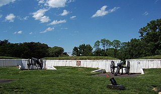
Fort Ward is a former Union Army installation now located in the city of Alexandria in the U.S. state of Virginia. It was the fifth largest fort built to defend Washington, D.C. in the American Civil War. It is currently well-preserved with 90-95% of its earthen walls intact.

Fort Reynolds (Virginia)

Fort Reynolds was a Union Army redoubt built as part of the defenses of Washington, D.C., in the American Civil War.

Fort C. F. Smith (Arlington, Virginia) United States historic place

Fort C.F. Smith was a lunette that the Union Army constructed in Alexandria County, Virginia, during 1863 as part of the Civil War defenses of Washington. It was named in honor of General Charles Ferguson Smith, who died from a leg infection that was aggravated by dysentery on April 25, 1862. Fort C. F. Smith connected the Potomac River to the Arlington Line, a row of fortifications south of Washington, D.C., that was intended to protect the capital of the United States from an invasion by the Confederate States Army.

Fort Foote

Fort Foote was an American Civil War-era wood and earthwork fort that was part of the wartime defenses of Washington, D.C., which helped defend the Potomac River approach to the city. It operated from 1863 to 1878, when the post was abandoned, and was used briefly during the First and Second World Wars. The remnants of the fort are located in Fort Foote Park, which is maintained by the U.S. National Park Service as part of the National Capital Parks-East system. The area's mailing address is Fort Washington, Maryland.

Fort Kearny (Washington, D.C.)

Fort Kearny was a fort constructed during the American Civil War as part of the defenses of Washington, D.C. Located near Tenleytown, in the District of Columbia, it filled the gap between Fort Reno and Fort DeRussy north of the city of Washington. The fort was named in honor of Maj. Gen. Philip Kearny of the Union Army, who was killed at the Battle of Chantilly on September 1, 1862. Three batteries of guns supported the fort, and are considered part of the fort's defenses.

Fort Greble was an American Civil War-era Union fortification constructed as part of the defenses of Washington, D.C. during that war. Named for First Lieutenant John Trout Greble, the first West Point graduate killed in the U.S. Civil War, it protected the junction of the Anacostia and Potomac rivers, and from its position on a bluff in the Congress Heights, precluded any bombardment of the Washington Navy Yard and southeastern portions of the city. It was supported by Fort Carroll to the northeast and Fort Foote to the south. It never fired a shot during the war, and after a brief stint as a U.S. Army Signal Corps training facility, was abandoned and the land returned to its natural state. As of July 2007, the site of the fort is a community park.

Fort Stanton (Washington, D.C.)

Fort Stanton was a Civil War-era fortification constructed in the hills above Anacostia in the District of Columbia, USA, and was intended to prevent Confederate artillery from threatening the Washington Navy Yard. It also guarded the approach to the bridge that connected Anacostia with Washington. Built in 1861, the fort was expanded throughout the war and was joined by two subsidiary forts: Fort Ricketts and Fort Snyder. Following the surrender of the Army of Northern Virginia, it was dismantled and the land returned to its original owner. It never saw combat. Abandoned after the war, the site of the fort was planned to be part of a grand "Fort Circle" park system encircling the city of Washington. Though this system of interconnected parks never was fully implemented, the site of the fort is today a park maintained by the National Park Service, and a historical marker stands near the fort's original location.

Fort Corcoran

Fort Corcoran was a wood-and-earthwork fortification constructed by the Union Army in northern Virginia as part of the defenses of Washington, D.C. during the American Civil War. Built in 1861, shortly after the occupation of Arlington, Virginia by Union forces, it protected the southern end of the Aqueduct Bridge and overlooked the Potomac River and Theodore Roosevelt Island, known as Mason's Island.

Barton S. Alexander

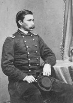
Barton Stone Alexander was a Union Army lieutenant colonel, engineer regiment commander and chief engineer for the defenses of Washington during the American Civil War. In recognition of his service, in 1866, he was appointed to the brevet rank of brigadier general in the regular army, to rank from March 13, 1865. He was a graduate of the U.S. Military Academy at West Point and served in the United States Army's Corps of Topographical Engineers, which at times was both a part of and separate from the United States Army Corps of Engineers. After graduating from West Point as a second lieutenant in the Class of 1842, he served in the Mexican–American War, building fortifications to protect American supply lines in the advance on Mexico City. After the end of the war, he was stationed in Washington, D.C., where he served as architect for the Scott Building and Quarters Buildings at the U.S. Soldiers' Home and took over the completion of the Smithsonian Institution Building after dissatisfaction with the pace of the first architect caused him to be dismissed.

Fort Runyon

Fort Runyon was a timber and earthwork fort constructed by the Union Army following the occupation of northern Virginia in the American Civil War in order to defend the southern approaches to the Long Bridge as part of the defenses of Washington, D.C. during that war. The Columbia Turnpike and Alexandria and Loudon Railroad ran through the pentagonal structure, which controlled access to Washington via the Long Bridge. With a perimeter of almost 1,500 yards (1,400 m), and due to its unusual shape it was approximately the same size, shape, and in almost the same location as the Pentagon, built 80 years later.

Fort Jackson (Virginia)

Fort Jackson was an American Civil War-era fortification in Virginia that defended the southern end of the Long Bridge, near Washington, D.C. Long Bridge connected Washington, D.C. to Northern Virginia and served as a vital transportation artery for the Union Army during the war. Fort Jackson was named for Jackson City, a seedy suburb of Washington that had been established on the south side of the Long Bridge in 1835. It was built in the days immediately following the Union Army's occupation of Northern Virginia in May 1861. The fort was initially armed with four cannon used to protect the bridge, but these were removed after the completion of the Arlington Line, a line of defenses built to the south. After 1862, the fort lacked weapons except for small arms and consisted of a wooden palisade backed by earthworks. Two cannon were restored to the fort in 1864 following the Battle of Fort Stevens. The garrison consisted of a single company of Union soldiers who inspected traffic crossing the bridge and guarded it from potential saboteurs.

Fort Lyon (Virginia) Historic fort in Virginia, USA

Fort Lyon was a timber and earthwork fortification constructed south of Alexandria, Virginia as part of the defenses of Washington, D.C. during the American Civil War. Built in the weeks following the Union defeat at Bull Run, Fort Lyon was situated on Ballenger's Hill south of Hunting Creek, and Cameron Run, near Mount Eagle. From its position on one of the highest points south of Alexandria, the fort overlooked Telegraph Road, the Columbia Turnpike, the Orange and Alexandria Railroad, the Little River Turnpike, and the southern approaches to the city of Alexandria, the largest settlement in Union-occupied Northern Virginia.

Fort Ellsworth

Fort Ellsworth was a timber and earthwork fortification constructed west of Alexandria, Virginia, as part of the defenses of Washington, D.C. during the American Civil War. Built in the weeks following the Union defeat at Bull Run, Fort Ellsworth was situated on a hill north of Hunting Creek, and Cameron Run,. From its position on one of the highest points west of Alexandria, the fort overlooked the Orange and Alexandria Railroad, the Little River Turnpike, and the southern approaches to the city of Alexandria, the largest settlement in Union-occupied Northern Virginia.

Fort Willard

Fort Willard is a former Union Army installation now located in the Belle Haven area of Fairfax County in the U.S. state of Virginia. It is currently undergoing preservation treatment to protect its earthen walls and trenches.

The 166th Ohio Infantry Regiment, sometimes 166th Ohio Volunteer Infantry was an infantry regiment in the Union Army during the American Civil War.

Fort Farnsworth

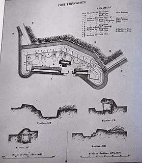
Fort Farnsworth is a former Union Army installation now located in the Huntington area of Fairfax County, Virginia. It was a timber and earthwork fortification constructed south of Alexandria, Virginia as part of the defenses of Washington, D.C. during the American Civil War. Nothing survives of the fort's structure as the Huntington Station of the Washington Metro occupies Fort Farnsworth's former hilltop site.

References

  1. Washington at Home: An Illustrated History of Neighborhoods in the National Capital, Kathryn Schneider Smith, Editor (Northridge, CA: Windsor Publications, Inc., produced in cooperation with the Columbia Historical Society, 1988), p. 76
  2. National Archives and Records Administration, Archives I, Record Group 29, Records of the Bureau of the Census, Microcopy 653, Eighth Census of the United States, 1860. Roll 103, 4th Ward, p. 1
  3. Helm, Judth Beck. Tenleytown, D.C., Country Village into City Neighborhood Washington, D.C. (Tennally Press, 1981), p. 168
  4. National Archives and Records Administration, Archives I, Record Group 92, Records of the Office of the Quartermaster General; Entry 225, Consolidated Correspondence File, "Defenses of Washington, DC," Box 484
  5. J.G. Barnard and W.F. Barry, "Report of the Engineer and Artillery Operations of the Army of the Potomac from Its Organization to the Close of the Peninsular Campaign," (New York: D. Van Nostrand, 1863), pp. 9-10.
  6. Margaret Leech, Reveille in Washington (New York: Harper & Brothers Publishers, 1941), pp. 101-110.
  7. U.S., War Department, The War of the Rebellion: A Compilation of the Official Records of the Union and Confederate Armies, 70 Volumes (Washington, DC: The Government Printing Office, 1880-1901) I, Volume 5, p. 11.
  8. Official Records, Serial I, Chapter 36, Part 3 (serial 69), p. 600
  9. Frank E. Vandiver, Jubal's Raid: General Early's Civil War Attack on Washington in 1864 (New York, NY: McGraw-Hill Book Company, Inc., 1960)
  10. 1 2 List of Washington, D.C. Forts Accessed September 6, 2007.
  11. Letter to the Editor, Democratic Press. New York State, March 11, 1864. Accessed September 6, 2007.
  12. Official Records, Serial I, Volume 25, Part 2. Chapter 37, p. 187.
  13. National Park Service, Fort Bayard Park
  14. Official Records, Series I, Volume 5 (Serial 14), p. 626
  15. Official Records, Series I, Volume 21 (Serial 23), p. 904
  16. Official Records, Series I, Volume 5 (Serial 14), p. 628
  17. U.S. National Park Service. History of Fort Stevens. Paragraph 2. Accessed September 6, 2007. Archived August 10, 2007, at the Wayback Machine
  18. 1 2 Official Records Series I, Volume 26, Part 2 (Serial 68), pp. 883-97
  19. Official Records, Serial I, Volum 37, Part 1. Chapter 49, p. 445.
  20. 1 2 Friends of Fort Bayard Park Website Accessed September 6, 2007.
  21. Official Records, Serial I, Volume 37, Part 1. Chapter 49, p. 466.
  22. Frank E. Vandiver, Jubal's Raid: General Early's Civil War Attack on Washington in 1864 (New York, NY: McGraw-Hill Book Company, Inc., 1960), p. 150.
  23. Official Records, (Serial 97) Series I, Volume XLVI, Part 3, p. 1130.
  24. Journal of the House of Representatives of the United States ... 66th Congress, 1st Session (Washington, DC: The Government Printing Office, 1919), p. 594
  25. "Linking of Forts Embodied in Plan," The Evening Star, December 4, 1925
  26. National Capital Park and Planning Commission." In H.S. Wagner and Charles G. Sauers, Study of the Organization of the National Capital Parks (Washington, DC: The National Park Service, National Capital Parks, 1939), p. 40
  27. Fort Bayard Park Has Much History, The Washington Post, July 13, 1930
  28. Martha Strayer, "JFK Settles Battle Over Ft. Drive," Washington Daily News, May 28, 1963.
  29. National Capital Planning Commission, Fort Park System: A Re-evaluation Study of Fort Drive, Washington, D.C. April 1965 By Fred W. Tuemmler and Associates, College Park, Maryland (Washington, DC: National Capital Planning Commission, 1965), pp. 3-9
  30. "Fort Sites Eyed for Future Use," The Washington Post, Friday, October 2, 1964.
  31. D.C. Parks and Recreation, listing of facilities [ permanent dead link ]