Fort Ethan Allen (Arlington, Virginia)

Last updated
Fort Ethan Allen
Fort Ethan Allen earthworks.JPG
A section of the earthworks that remain.
Location map District of Columbia street.png
Red pog.svg
USA Virginia location map.svg
Red pog.svg
Usa edcp location map.svg
Red pog.svg
LocationAddress Restricted, Arlington, Virginia
Coordinates 38°55′26″N77°7′26″W / 38.92389°N 77.12389°W / 38.92389; -77.12389 Coordinates: 38°55′26″N77°7′26″W / 38.92389°N 77.12389°W / 38.92389; -77.12389
Area9.8 acres (4.0 ha)
Built1861
ArchitectBarnard, Gen. John Gross
NRHP reference No. 04000052 [1]
VLR No.000-5819
Significant dates
Added to NRHPFebruary 11, 2004
Designated VLRDecember 3, 2003 [2]

Fort Ethan Allen was an earthwork fortification that the Union Army built in 1861 on the property of Gilbert Vanderwerken in Alexandria County (now Arlington County), Virginia, as part of the Civil War defenses of Washington (see Washington, D.C., in the American Civil War). The remains of the fort are now within Arlington County's Fort Ethan Allen Park. [3] [4] [5]

Contents

History

Map of Civil War fortifications near Chain Bridge, including Fort Ethan Allen (September 1861) Defending Chain Bridge, 1861 (493989022) (2).jpg
Map of Civil War fortifications near Chain Bridge, including Fort Ethan Allen (September 1861)

The Union Army built Fort Ethan Allen in September 1861, shortly after the Army's rout at the First Battle of Bull Run (Manassas) in late July of that year. The fortification was a large bastion-style fort that was located in the County's highlands near the Potomac River. [3]

Before the Army constructed the fort, farmland and forests filled the area. To allow for clear lines of sight toward other fortifications and approaches to Washington, D.C., the Army removed trees and other vegetation that were near the site. [3]

Built like other northern Virginia defenses, the fort was constructed following the directives of General John G. Barnard of the United States Army Corps of Engineers. The walls of the fort were made stronger than most other such forts because it protected Chain Bridge, one of the most important approaches to Washington from the south. [3]

The Chain Bridge forts in Virginia (Fort Marcy and Fort Ethan Allen) considerably strengthened the web of fortifications that defended the northern flank of the Arlington Line. Because of its size and location, Fort Ethan Allen was a critical element of this comer of the Washington defenses. [3]

A line of trenches and roads, which were used to transport troops and supplies, connected the fortifications of the Arlington Line. In addition, the fort was connected by a long series of trenches and earthworks to the nearby Fort Marcy and Potomac River. [3] [5]

The fort consisted of four main faces, with additional angles built into the north and east faces. It maintained a perimeter of 768 yards (702 m) with emplacements for 34 guns. Interior structures included two bomb-proofs, ammunition magazines, and other supporting structures. [3] [6]

A May 7, 1864, report from the Union Army's Inspector of Artillery (see Union Army artillery organization) noted the following:

Fort Ethan Allen, Col. A. A. Gibson commanding.–Garrison, nine companies Second Pennsylvania Heavy Artillery–1 colonel, 29 commissioned officers, 1,346 men, and 1 ordnance-sergeant. Armament, nine 6-pounder field guns, three 10-pounder Parrotts, three 32-pounder bronze howitzers, four 24-pounder siege guns, two 8-inch sea-coast howitzers, eleven 30-pounder Parrotts, six 24-pounder Coehorn mortars, four 10-inch siege mortars. Magazines, four; dry and serviceable. Ammunition, full supply and in good order. Implements, complete and serviceable. Drill in artillery, ordinary; needs improving. Drill in infantry, very indifferent; needs much improving. Discipline, indifferent. Garrison larger than necessary. Cavalry garrison, one company (E) Thirteenth New York Cavalry–2 commissioned officers, 78 enlisted men, 53 equipped, 52 horses. [7]

1965 historical marker at Fort Ethan Allen (2013) Fort Ethan Allen historical markers.JPG
1965 historical marker at Fort Ethan Allen (2013)

There was no military action at the fort throughout the Civil War; the only Confederate Army attack on Washington's fortifications occurred north of the city in 1864 during the Battle of Fort Stevens. Perhaps the most memorable wartime occurrence at Fort Ethan Allen was a visit by President Abraham Lincoln during the fort's construction. [3]

In 1965, the Arlington County government erected a historic marker near the site of the fort. [8] The Arlington County Board designated the fort to be a local historic district on October 3, 1978. [9] The National Park Service listed the fort on the National Register of Historic Places on February 11, 2004. [1] [3] [9]

In 2014, the Arlington County government installed nine interpretive panels within Fort Ethan Allen Park as part of its Neighborhood Conservation Program. [10] In addition, the Virginia Civil War Trails [11] has placed a historic marker near the fort's site. [12]

Existing remnants

Fort Ethan Allen retains several major aboveground features. These include large earthworks, one bombproof, gun platforms, and traces of magazines. [3] The fort's remaining interior structures remain visible, as do the fort's south face, centrally located bombproof, and remaining north face structures. [3] An outlier trench, which the Arlington County Board has designated as a local historic district, remains to the southwest of the fort. [3] [13] [14]

See also

Notes

  1. 1 2 "National Register Information System". National Register of Historic Places . National Park Service. March 13, 2009.
  2. "Virginia Landmarks Register". Virginia Department of Historic Resources. Archived from the original on 2013-09-21. Retrieved 2013-05-12.
  3. 1 2 3 4 5 6 7 8 9 10 11 12 Trieschmann, Laura V.; O'Connell, Kim A. (EHT Traceries) (August 2003). "Fort Ethan Allen" (PDF). National Register of Historic Places Inventory: Registration Form. Virginia Department of Historic Resources. Archived (PDF) from the original on 2017-02-07. Retrieved 2018-03-10. and Accompanying two photos Archived 2012-09-26 at the Wayback Machine
  4. "Fort Ethan Allen". Parks and Recreation. Arlington County government. Archived from the original on 2018-03-11. Retrieved 2018-03-08.
  5. 1 2 "Sketching the Civil War Defenses of Washington: Fort Marcy to Fort Ethan Allen" (PDF). National Park Service. Archived (PDF) from the original on 2017-05-26. Retrieved 2018-03-10.
  6. Cooling, pp. 128–136 Archived 2016-04-24 at the Wayback Machine .
  7. Howe, A.P., Brigadier-General, Inspector of Artillery (1864-05-17). Scott, Robert N. (ed.). Report on the inspection of the defenses of Washington, made by the order of the Secretary of War: Fort Ethan Allen, Col. A. A. Gibson commanding. The War of the Rebellion: A Compilation of the Official Records of the Union and Confederate Armies. Published under the direction of the Secretary of War (1880–1891). Series 1 (Military Operations), Volume 36, Part 2, Chapter 48 (Operations in Southeastern Virginia and North Carolina). Washington, DC: United States Government Printing Office. p. 891. LCCN   03003452. OCLC   224137463 . Retrieved 2018-03-15 via HathiTrust Digital Library. (See: Official Records of the War of the Rebellion)
  8. Swain, Craig (2007-09-04). Prats, J.J. (ed.). ""Fort Ethan Allen" marker". HMdb: The Historical Marker Database. Archived from the original on 2017-03-17. Retrieved 2018-03-10.
  9. 1 2 "Fort Ethan Allen". Projects and Planning. Arlington County, Virginia government. Archived from the original on 2016-05-21. Retrieved 2018-03-09.
  10. (1) "Fort Ethan Allen Interpretive Panels" (PDF). Arlington County government. Archived (PDF) from the original on 2018-03-11. Retrieved 2018-03-10.
    (2) "Fort Ethan Allen Park". Projects and Planning. Arlington County government. Archived from the original on 2016-05-21. Retrieved 2018-03-10.
    (3) "Neighborhood Conservation". Projects and Planning. Arlington County government. Archived from the original on 2016-05-22. Retrieved 2018-03-10.
    (4) WTOP staff (2014-03-17). "Civil War Re-Enactments Scheduled for Sunday". WTOP. Archived from the original on 2018-03-11. Retrieved 2018-03-10.
    (5) Osborne, Robby (2014-03-20). "The Park Between the States: Ethan Allen Park gets a historic face lift as its use as a Civil War fort is recognized". Northern Virginia Magazine . Archived from the original on 2018-03-11. Retrieved 2018-03-10.
  11. "Virginia Civil War Trails". Virginia Is For Lovers. Archived from the original on 2018-03-11. Retrieved 2018-03-10.
  12. Swain, Craig (2007-09-04). Prats, J.J. (ed.). ""Fort Ethan Allen: Mr. Lincoln's Forts — Defenses of Washington – 1861–1865" marker". HMdb: The Historical Marker Database. Archived from the original on 2018-03-11. Retrieved 2018-03-10.
  13. Cooling, p. xii Archived 2018-03-12 at the Wayback Machine Introduction: The State and Fate of the Defenses of Washington
  14. "Local Historic Districts". Projects and Planning. Arlington County, Virginia Government. Archived from the original on 2018-03-08. Retrieved 2018-03-08.

Related Research Articles

<span class="mw-page-title-main">Fort Myer</span> United States historic place

Fort Myer is the previous name used for a U.S. Army post next to Arlington National Cemetery in Arlington County, Virginia, and across the Potomac River from Washington, D.C. Founded during the American Civil War as Fort Cass and Fort Whipple, the post merged in 2005 with the neighboring Marine Corps installation, Henderson Hall, and is today named Joint Base Myer–Henderson Hall.

<span class="mw-page-title-main">Fort Marcy (Virginia)</span>

Fort Marcy was a Union fortification protecting Washington, D.C. during the American Civil War. Its remains are now administered by the National Park Service as part of the George Washington Memorial Parkway in Fairfax County, Virginia.

<span class="mw-page-title-main">Fort Albany (Arlington, Virginia)</span>

Fort Albany was a bastioned earthwork that the Union Army built in Arlington County in Virginia. The Army constructed the fort during May 1861 as part of its Civil War defenses of Washington.

<span class="mw-page-title-main">Fort Richardson (Arlington, Virginia)</span> Civil war fort in Arlington County, Virginia

Fort Richardson was a detached redoubt that the Union Army constructed in September 1861 as part of the Civil War defenses of Washington. The Army built the fort shortly after its rout at the First Battle of Bull Run (Manassas) in late July 1861. The Army named the fort after General Israel B. Richardson, whose division had been deployed to defend the City of Washington against attack by way of the Columbia Turnpike.

<span class="mw-page-title-main">Fort Scott (Arlington, Virginia)</span> Historical fort in Arlington, Virginia, United States

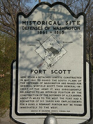
Fort Scott was a detached lunette constructed in May 1861 to guard the south flank of the defenses of Washington during the American Civil War. It was named for General Winfield Scott, who was then General-in-Chief of the Union Army. An historic marker and a small remnant of the fort are the only evidence of the site of the fort on the grounds of what is now Fort Scott Park in Arlington County, Virginia.

<span class="mw-page-title-main">Fort Ward (Virginia)</span> United States historic place

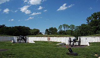
Fort Ward is a former Union Army installation now located in the city of Alexandria in the U.S. state of Virginia. It was the fifth largest fort built to defend Washington, D.C. in the American Civil War. It is currently well-preserved with 90-95% of its earthen walls intact.

<span class="mw-page-title-main">Fort Reynolds (Virginia)</span>

Fort Reynolds was a Union Army redoubt built as part of the defenses of Washington, D.C., in the American Civil War.

<span class="mw-page-title-main">Arlington Line</span>

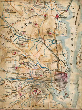
The Arlington Line was a series of fortifications that the Union Army erected in Alexandria County, Virginia, to protect the City of Washington during the American Civil War.

<span class="mw-page-title-main">Fort C. F. Smith (Arlington, Virginia)</span> Archaeological site in Virginia, United States

Fort C.F. Smith was a lunette that the Union Army constructed in Alexandria County, Virginia, during 1863 as part of the Civil War defenses of Washington. It was named in honor of General Charles Ferguson Smith, who died from a leg infection that was aggravated by dysentery on April 25, 1862. Fort C. F. Smith connected the Potomac River to the Arlington Line, a row of fortifications south of Washington, D.C., that was intended to protect the capital of the United States from an invasion by the Confederate States Army.

<span class="mw-page-title-main">Fort Corcoran</span>

Fort Corcoran was a wood-and-earthwork fortification constructed by the Union Army in northern Virginia as part of the defenses of Washington, D.C. during the American Civil War. Built in 1861, shortly after the occupation of Arlington, Virginia by Union forces, it protected the southern end of the Aqueduct Bridge and overlooked the Potomac River and Theodore Roosevelt Island, known as Mason's Island.

<span class="mw-page-title-main">Fort Jackson (Virginia)</span> Historical fort in Virginia

Fort Jackson was an American Civil War-era fortification in Virginia that defended the southern end of the Long Bridge, near Washington, D.C. Long Bridge connected Washington, D.C. to Northern Virginia and served as a vital transportation artery for the Union Army during the war. Fort Jackson was named for Jackson City, a seedy suburb of Washington that had been established on the south side of the Long Bridge in 1835. It was built in the days immediately following the Union Army's occupation of Northern Virginia in May 1861. The fort was initially armed with four cannon used to protect the bridge, but these were removed after the completion of the Arlington Line, a line of defenses built to the south. After 1862, the fort lacked weapons except for small arms and consisted of a wooden palisade backed by earthworks. Two cannon were restored to the fort in 1864 following the Battle of Fort Stevens. The garrison consisted of a single company of Union soldiers who inspected traffic crossing the bridge and guarded it from potential saboteurs.

<span class="mw-page-title-main">Fort Lyon (Virginia)</span> Historic fort in Virginia, USA

Fort Lyon was a timber and earthwork fortification constructed south of Alexandria, Virginia as part of the defenses of Washington, D.C. during the American Civil War. Built in the weeks following the Union defeat at Bull Run, Fort Lyon was situated on Ballenger's Hill south of Hunting Creek, and Cameron Run, near Mount Eagle. From its position on one of the highest points south of Alexandria, the fort overlooked Telegraph Road, the Columbia Turnpike, the Orange and Alexandria Railroad, the Little River Turnpike, and the southern approaches to the city of Alexandria, the largest settlement in Union-occupied Northern Virginia.

<span class="mw-page-title-main">Pittsburgh in the American Civil War</span>

Pittsburgh, Pennsylvania was a thriving and important city during the American Civil War, and provided a significant source of personnel, war materiel, armament, ammunition, and supplies to the Union Army. Situated at the confluence of the Monongahela, Allegheny and Ohio rivers, Pittsburgh was an important transportation hub for both riverine and rail transport, as well as overland via its system of roads.

<span class="mw-page-title-main">Fort Ellsworth</span>

Fort Ellsworth was a timber and earthwork fortification constructed west of Alexandria, Virginia, as part of the defenses of Washington, D.C. during the American Civil War. Built in the weeks following the Union defeat at Bull Run, Fort Ellsworth was situated on a hill north of Hunting Creek, and Cameron Run,. From its position on one of the highest points west of Alexandria, the fort overlooked the Orange and Alexandria Railroad, the Little River Turnpike, and the southern approaches to the city of Alexandria, the largest settlement in Union-occupied Northern Virginia.

<span class="mw-page-title-main">Civil War Defenses of Washington</span> United States historic place

The Civil War Defenses of Washington were a group of Union Army fortifications that protected the federal capital city, Washington, D.C., from invasion by the Confederate States Army during the American Civil War.

<span class="mw-page-title-main">Fort Willard</span>

Fort Willard is a former Union Army installation now located in the Belle Haven area of Fairfax County in the U.S. state of Virginia. It is currently undergoing preservation treatment to protect its earthen walls and trenches.

<span class="mw-page-title-main">Battery Kemble Park</span> Park in Washington, D.C., U.S.

Battery Kemble Park is a park in Northwest Washington D.C., administered by the National Park Service.

<span class="mw-page-title-main">Fort Craig (Virginia)</span> Civil War-era fort in Arlington County, Virginia

Fort Craig was a small lunette that the Union Army constructed in September 1861 in Arlington County in Virginia during the American Civil War. The lunette was part of the Civil War defenses of Washington.

<span class="mw-page-title-main">Fort Tillinghast</span>

Fort Tillinghast was a small lunette that the Union Army constructed in Alexandria County, Virginia, as part of the Civil War defenses of Washington. Fort Tillinghast stood about 0.6 miles away from Arlington House, the Union-occupied estate of Confederate General Robert E. Lee.

Nauck is a neighborhood in the southern part of Arlington County, Virginia, known locally as Green Valley. It is bordered by Four Mile Run and Shirlington to the south, Douglas Park to the west, I-395 to the east, and Columbia Heights and the Army-Navy Country Club to the north. The southeastern corner of the neighborhood borders the City of Alexandria.

References