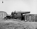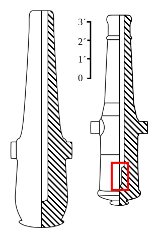
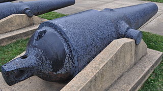
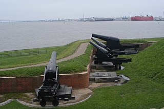
The Rodman gun is any of a series of American Civil War–era columbiads designed by Union artilleryman Thomas Jackson Rodman (1815–1871). The guns were designed to fire both shot and shell. These heavy guns were intended to be mounted in seacoast fortifications. They were built in 8-inch, 10-inch, 13-inch, 15-inch, and 20-inch bore. Other than size, the guns were all nearly identical in design, with a curving bottle shape, large flat cascabels with ratchets or sockets for the elevating mechanism. Rodman guns were true guns that did not have a howitzer-like powder chamber, as did many earlier columbiads. Rodman guns differed from all previous artillery because they were hollow cast, a new technology that Rodman developed that resulted in cast-iron guns that were much stronger than their predecessors.

The Parrott rifle was a type of muzzle-loading rifled artillery weapon used extensively in the American Civil War.
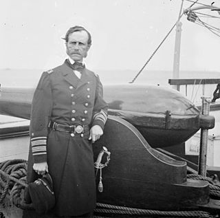
Dahlgren guns were muzzle-loading naval artillery designed by Rear Admiral John A. Dahlgren USN, mostly used in the period of the American Civil War. Dahlgren's design philosophy evolved from an accidental explosion in 1849 of a 32 lb (14.5 kg) gun being tested for accuracy, killing a gunner. He believed a safer, more powerful naval cannon could be designed using more scientific design criteria. Dahlgren guns were designed with a smooth curved shape, equalizing strain and concentrating more weight of metal in the gun breech where the greatest pressure of expanding propellant gases needed to be met to keep the gun from bursting. Because of their rounded contours, Dahlgren guns were nicknamed "soda bottles", a shape which became their most identifiable characteristic.
The Brooke rifle was a type of rifled, muzzle-loading naval and coast defense gun designed by John Mercer Brooke, an officer in the Confederate States Navy. They were produced by plants in Richmond, Virginia, and Selma, Alabama, between 1861 and 1865 during the American Civil War. They served afloat on Confederate ships and ashore in coast defense batteries operated by the Confederate States Army.
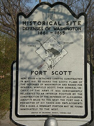
Fort Scott was a detached lunette constructed in May 1861 to guard the south flank of the defenses of Washington during the American Civil War. It was named for General Winfield Scott, who was then General-in-Chief of the Union Army. An historic marker and a small remnant of the fort are the only evidence of the site of the fort on the grounds of what is now Fort Scott Park in Arlington County, Virginia.

Fort Bunker Hill was one of seven temporary earthwork forts part of the Civil War Defenses of Washington, D.C., during the Civil War built in the Northeast quadrant of the city at the beginning of the Civil War by the Union Army to protect the city from the Confederate Army. From west to east, the forts were: Fort Slocum, Fort Totten, Fort Slemmer, Fort Bunker Hill, Fort Saratoga, Fort Thayer and Fort Lincoln. Unlike other forts, today very little remains of the structure.
Fort Foote was an American Civil War-era wood and earthwork fort that was part of the wartime defenses of Washington, D.C., which helped defend the Potomac River approach to the city. It operated from 1863 to 1878, when the post was abandoned, and was used briefly during the First and Second World Wars. The remnants of the fort are located in Fort Foote Park, which is maintained by the National Park Service as part of the National Capital Parks-East system. The area's mailing address is Fort Washington, Maryland.
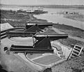
Seacoast defense was a major concern for the United States from its independence until World War II. Before airplanes, many of America's enemies could only reach it from the sea, making coastal forts an economical alternative to standing armies or a large navy. After the 1940s, it was recognized that fixed fortifications were obsolete and ineffective against aircraft and missiles. However, in prior eras foreign fleets were a realistic threat, and substantial fortifications were built at key locations, especially protecting major harbors.

Fort Lyon was a timber and earthwork fortification constructed south of Alexandria, Virginia as part of the defenses of Washington, D.C. during the American Civil War. Built in the weeks following the Union defeat at Bull Run, Fort Lyon was situated on Ballenger's Hill south of Hunting Creek, and Cameron Run, near Mount Eagle. From its position on one of the highest points south of Alexandria, the fort overlooked Telegraph Road, the Columbia Turnpike, the Orange and Alexandria Railroad, the Little River Turnpike, and the southern approaches to the city of Alexandria, the largest settlement in Union-occupied Northern Virginia.

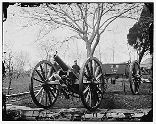
Siege artillery is heavy artillery primarily used in military attacks on fortified positions. At the time of the American Civil War, the U.S. Army classified its artillery into three types, depending on the gun's weight and intended use. Field artillery were light pieces that often traveled with the armies. Siege and garrison artillery were heavy pieces that could be used either in attacking or defending fortified places. Seacoast artillery were the heaviest pieces and were intended to be used in permanent fortifications along the seaboard. They were primarily designed to fire on attacking warships. The distinctions are somewhat arbitrary, as field, siege and garrison, and seacoast artillery were all used in various attacks and defenses of fortifications. This article will focus on the use of heavy artillery in the attack of fortified places during the American Civil War.

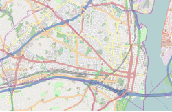
The Civil War Defenses of Washington were a group of Union Army fortifications that protected the federal capital city, Washington, D.C., from invasion by the Confederate States Army during the American Civil War.
The Wiard rifle refers to several weapons invented by Norman Wiard, most commonly a semi-steel light artillery piece in six-pounder and twelve-pounder calibers. About 60 were manufactured between 1861 and 1862 during the American Civil War, at O'Donnell's Foundry, New York City: "although apparently excellent weapons, [they] do not seem to have been very popular". Wiard also designed a rifled steel version of the Dahlgren boat howitzer, among other gun types. Further, Wiard unsuccessfully attempted to develop a 15 in (381 mm) rifled gun for the US Navy and proposed a 20 in (510 mm) gun. In 1881 he unsuccessfully proposed various "combined rifle and smoothbore" weapon conversions of Rodman guns and Parrott rifles.

Fort Willard is a former Union Army installation now located in the Belle Haven area of Fairfax County in the U.S. state of Virginia. It is currently undergoing preservation treatment to protect its earthen walls and trenches.

Battery Kemble Park is a park in Northwest Washington D.C., administered by the National Park Service.

Fort Craig was a small lunette that the Union Army constructed in September 1861 in Arlington County in Virginia during the American Civil War. The lunette was part of the Civil War defenses of Washington.
Fort Tillinghast was a small lunette that the Union Army constructed in Alexandria County, Virginia, as part of the Civil War defenses of Washington. Fort Tillinghast stood about 0.6 miles away from Arlington House, the Union-occupied estate of Confederate General Robert E. Lee.

Fort Lincoln was one of seven temporary earthwork forts part of the Civil War Defenses of Washington, DC during the Civil War built in the Northeast quadrant of the city at the beginning of the Civil War by the Union Army to protect the city from the Confederate Army. From west to east, the forts were as follow: Fort Slocum, Fort Totten, Fort Slemmer, Fort Bunker Hill, Fort Saratoga, Fort Thayer and Fort Lincoln.

The following is the organization of the Union forces engaged in the Red River campaign, during the American Civil War in 1864. Order of battle compiled from the army organization during the campaign. The Confederate order of battle is listed separately.
Fort Slocum was one of seven temporary earthwork forts, part of the Civil War Defenses of Washington, D.C., during the Civil War, built in the Northeast quadrant of the city after the beginning of the war by the Union Army to protect the city from the Confederate Army. From west to east, the forts were as follow: Fort Slocum, Fort Totten, Fort Slemmer, Fort Bunker Hill, Fort Saratoga, Fort Thayer and Fort Lincoln.