Fort Tillinghast, Major Rolfe commanding.–Garrison, two companies First Massachusetts Heavy Artillery– 7 commissioned officers, 1 ordnance-sergeant, 220 men. Armament, one 24- pounder field howitzer (smooth), two 20-pounder Parrotts (rifled), three 24-pounder siege guns (smooth), one 24-pounder F. D. howitzer, four 30-pounder Parrotts (rifled), two 24-pounder Coehorn mortars. Magazines being rebuilt; at present unserviceable; work progressing slowly; ammunition kept in bomb-proof. Ammunition, full supply and serviceable. Implements, complete and in good order. Drill in artillery, fair. Drill in infantry, fair. Discipline, fair. Garrison sufficient for the work.[2]
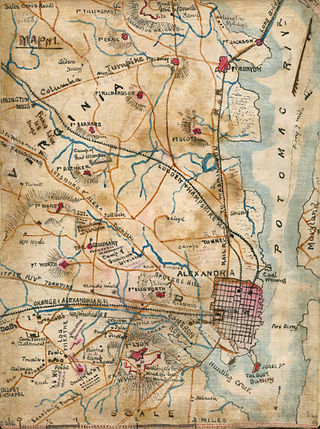
In June, 1865, Fort Tillinghast was ordered dismantled and the site returned to its previous owners.[3] The fortification stood near 205 North Wayne Street in Arlington, but no sections remain today. A historic marker, near the intersection of Arlington Boulevard (U.S. 50) and North 2nd Street in Arlington, shows the location where the fort once stood. The marker depicts the fort's position on a map of the city's defenses and states:
Here stood Fort Tillinghast, a lunette in the Arlington Line constructed in August 1861. It had a perimeter of 298 yards and emplacements for 13 guns. A model of this fort, typical of all lunettes in the Arlington Line, can be seen at the Hume School museum of the Arlington Historical Society.[4]
Fort Myer is the previous name used for a U.S. Army post next to Arlington National Cemetery in Arlington County, Virginia, and across the Potomac River from Washington, D.C. Founded during the American Civil War as Fort Cass and Fort Whipple, the post merged in 2005 with the neighboring Marine Corps installation, Henderson Hall, and is today named Joint Base Myer–Henderson Hall.
Fort Ethan Allen was an earthwork fortification that the Union Army built in 1861 on the property of Gilbert Vanderwerken in Alexandria County, Virginia, as part of the Civil War defenses of Washington. The remains of the fort are now within Arlington County's Fort Ethan Allen Park.
Fort Albany was a bastioned earthwork that the Union Army built in Arlington County in Virginia. The Army constructed the fort during May 1861 as part of its Civil War defenses of Washington.
Fort Richardson was a detached redoubt that the Union Army constructed in September 1861 as part of the Civil War defenses of Washington. The Army built the fort shortly after its rout at the First Battle of Bull Run (Manassas) in late July 1861. The Army named the fort after General Israel B. Richardson, whose division had been deployed to defend the City of Washington against attack by way of the Columbia Turnpike.
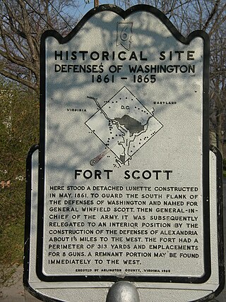
Fort Scott was a detached lunette constructed in May 1861 to guard the south flank of the defenses of Washington during the American Civil War. It was named for General Winfield Scott, who was then General-in-Chief of the Union Army. An historic marker and a small remnant of the fort are the only evidence of the site of the fort on the grounds of what is now Fort Scott Park in Arlington County, Virginia.
The Arlington Line was a series of fortifications that the Union Army erected in Alexandria County, Virginia, to protect the City of Washington during the American Civil War.
Fort Woodbury was part of the Arlington Line, an extensive network of fortifications erected in present-day Arlington County, Virginia to protect Washington, D.C. from Confederate attack during the American Civil War. Construction began on the Arlington Line in May 1861, shortly after war broke out, and accelerated after the Union's defeat at the First Battle of Bull Run in July 1861.
Fort Bunker Hill was one of seven temporary earthwork forts part of the Civil War Defenses of Washington, D.C., during the Civil War built in the Northeast quadrant of the city at the beginning of the Civil War by the Union Army to protect the city from the Confederate Army. From west to east, the forts were: Fort Slocum, Fort Totten, Fort Slemmer, Fort Bunker Hill, Fort Saratoga, Fort Thayer and Fort Lincoln. Unlike other forts, today very little remains of the structure.
Fort C.F. Smith was a lunette that the Union Army constructed in Alexandria County, Virginia, during 1863 as part of the Civil War defenses of Washington. It was named in honor of General Charles Ferguson Smith, who died from a leg infection that was aggravated by dysentery on April 25, 1862. Fort C. F. Smith connected the Potomac River to the Arlington Line, a row of fortifications south of Washington, D.C., that was intended to protect the capital of the United States from an invasion by the Confederate States Army.
Fort Greble was an American Civil War-era Union fortification constructed as part of the defenses of Washington, D.C. during that war. Named for First Lieutenant John Trout Greble, the first West Point graduate killed in the U.S. Civil War, it protected the junction of the Anacostia and Potomac rivers, and from its position on a bluff in the Congress Heights, precluded any bombardment of the Washington Navy Yard and southeastern portions of the city. It was supported by Fort Carroll to the northeast and Fort Foote to the south. It never fired a shot during the war, and after a brief stint as a U.S. Army Signal Corps training facility, was abandoned and the land returned to its natural state. As of July 2007, the site of the fort is a community park.
Fort Corcoran was a wood-and-earthwork fortification constructed by the Union Army in northern Virginia as part of the defenses of Washington, D.C. during the American Civil War. Built in 1861, shortly after the occupation of Arlington, Virginia by Union forces, it protected the southern end of the Aqueduct Bridge and overlooked the Potomac River and Theodore Roosevelt Island, known as Mason's Island.
Fort Lyon was a timber and earthwork fortification constructed south of Alexandria, Virginia, as part of the defenses of Washington, D.C. during the American Civil War. Built in the weeks following the Union defeat at Bull Run, Fort Lyon was situated on Ballenger's Hill south of Hunting Creek, and Cameron Run, near Mount Eagle. From its position on one of the highest points south of Alexandria, the fort overlooked Telegraph Road, the Columbia Turnpike, the Orange and Alexandria Railroad, the Little River Turnpike, and the southern approaches to the city of Alexandria, the largest settlement in Union-occupied Northern Virginia.
Siege artillery is heavy artillery primarily used in military attacks on fortified positions. At the time of the American Civil War, the U.S. Army classified its artillery into three types, depending on the gun's weight and intended use. Field artillery were light pieces that often traveled with the armies. Siege and garrison artillery were heavy pieces that could be used either in attacking or defending fortified places. Seacoast artillery were the heaviest pieces and were intended to be used in permanent fortifications along the seaboard. They were primarily designed to fire on attacking warships. The distinctions are somewhat arbitrary, as field, siege and garrison, and seacoast artillery were all used in various attacks and defenses of fortifications. This article will focus on the use of heavy artillery in the attack of fortified places during the American Civil War.
Fort Willard is a former Union Army installation now located in the Belle Haven area of Fairfax County in the U.S. state of Virginia. It is currently undergoing preservation treatment to protect its earthen walls and trenches.
Battery Kemble Park is a park in Northwest Washington D.C., administered by the National Park Service.
Fort Craig was a small lunette that the Union Army constructed in September 1861 in Arlington County in Virginia during the American Civil War. The lunette was part of the Civil War defenses of Washington.
Fort Totten Park is an American Civil War memorial on the site of a Union fort in Washington, DC. It is under the management of the National Park Service.
Fort Lincoln was one of seven temporary earthwork forts part of the Civil War Defenses of Washington, DC during the Civil War built in the Northeast quadrant of the city at the beginning of the Civil War by the Union Army to protect the city from the Confederate Army. From west to east, the forts were as follow: Fort Slocum, Fort Totten, Fort Slemmer, Fort Bunker Hill, Fort Saratoga, Fort Thayer and Fort Lincoln.
Fort Slocum was one of seven temporary earthwork forts, part of the Civil War Defenses of Washington, D.C., during the Civil War, built in the Northeast quadrant of the city after the beginning of the war by the Union Army to protect the city from the Confederate Army. From west to east, the forts were as follow: Fort Slocum, Fort Totten, Fort Slemmer, Fort Bunker Hill, Fort Saratoga, Fort Thayer and Fort Lincoln.
Fort Thayer was one of seven temporary earthwork forts part of the Civil War Defenses of Washington, D.C., during the Civil War built in the Northeast quadrant of the city at the beginning of the Civil War by the Union Army to protect the city from the Confederate Army. From west to east, the forts were as follow: Fort Slocum, Fort Totten, Fort Slemmer, Fort Bunker Hill, Fort Saratoga, Fort Thayer and Fort Lincoln. Unlike other forts, today nothing remains of the structure.
This page is based on this Wikipedia article Text is available under the CC BY-SA 4.0 license; additional terms may apply. Images, videos and audio are available under their respective licenses.