Fort Sumner | |
---|---|
Part of the Civil War Defenses of Washington | |
Montgomery County, Maryland | |
Coordinates | 38°57′19″N77°07′26″W / 38.9554°N 77.1240°W |
Type | Earthwork fort |
Site information | |
Controlled by | Union Army |
Condition | Residential area |
Site history | |
Built | 1861 |
Built by | U.S. Army Corps of Engineers |
In use | 1861–1865 |
Materials | Earth, timber |
Demolished | 1953 |
Battles/wars | American Civil War |
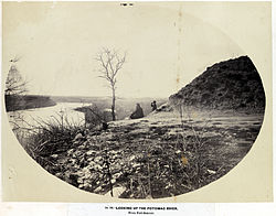
Fort Sumner was built during the American Civil War by the Union Army in the Brookmont section of Bethesda, Maryland, just northwest of Washington, D.C.
The earthwork fort was an 1863 expansion of Fort Alexander, Fort Ripley, and Fort Franklin, which were built to protect the Washington Aqueduct, the new water supply for the city, and the adjacent Potomac River shoreline. [1] [2] Fort Sumner was named for Major General Edwin Vose Sumner, who died in 1863 from fever he contracted while at his daughter's house.
The fort had a commanding view above the Potomac River and included 30 artillery pieces. In addition to the aforementioned components, the site included Battery Bailey and Battery Benson, overlooking Little Falls Branch. [3]
Fort Sumner was razed in 1953. [4] There are a few visible remains of Battery Bailey in Westmoreland Hills Park, which can be seen from the adjacent Capital Crescent Trail. [3] Part of the site was acquired by the Army Map Service (AMS) early in World War II and renamed Fort Sumner. The AMS was renamed US Army Topographic Command in 1968 and merged into the Defense Mapping Agency in 1972, at which time the site was renamed Defense Mapping Agency Topographic Center. The Defense Mapping Agency and its successors, the National Imagery and Mapping Agency and the National Geospatial-Intelligence Agency, occupied the site until the early 2010s. The residential area that was built over Fort Sumner has a plaque about the fort at Sangamore Road and West Path Way, and portions of it are named "Fort Sumner Hills" and "Sumner Village". [1]
The National Geospatial-Intelligence Agency (NGA) is a combat support agency within the United States Department of Defense whose primary mission is collecting, analyzing, and distributing geospatial intelligence (GEOINT) in support of national security. Initially known as the National Imagery and Mapping Agency (NIMA) from 1996 to 2003, it is a member of the United States Intelligence Community.
XXII Corps was a corps in the Union Army during the American Civil War. It was created on February 2, 1863, to consist of all troops garrisoned in Washington, D.C., and included three infantry divisions and one of cavalry. Many of its units were transferred to the Army of the Potomac during Grant's Overland Campaign.
Fort Washington, located near the community of Fort Washington, Maryland, was for many decades the only defensive fort protecting Washington, D.C. The original fort, overlooking the Potomac River, was completed in 1809, and was begun as Fort Warburton, but renamed in 1808. During the War of 1812, the fort was destroyed by its own garrison during a British advance.
Fort Ward is a former Union Army installation now located in the city of Alexandria in the U.S. state of Virginia. It was the fifth largest fort built to defend Washington, D.C. in the American Civil War. It is currently well-preserved with 90-95% of its earthen walls intact.
Fort Reynolds was a Union Army redoubt built as part of the defenses of Washington, D.C., in the American Civil War.
Battery Rodgers was a gun emplacement that composed a portion of the American Civil War defenses of the American capital city of Washington, D.C.
The 10th Rhode Island Infantry Regiment served for three months in the summer of 1862. It served, along with its sister units—the 9th Rhode Island Infantry Regiment and the 10th Rhode Island Battery—in the defenses of Washington, D.C.
The Civil War Defenses of Washington were a group of Union Army fortifications that protected the federal capital city, Washington, D.C., from invasion by the Confederate States Army during the American Civil War.
Fort Willard is a former Union Army installation now located in the Belle Haven area of Fairfax County in the U.S. state of Virginia. It is currently undergoing preservation treatment to protect its earthen walls and trenches.
Fort O'Rourke is a former Union Army installation now located in the Belle Haven area of Fairfax County in the U.S. state of Virginia. It was the southernmost fort built to defend Washington, D.C. in the American Civil War.
The 2nd Maine Light Artillery Battery was an artillery battery that served in the Union Army during the American Civil War.
Battery D, 1st Rhode Island Light Artillery Regiment was an artillery battery that served in the Union Army during the American Civil War.
The Army Map Service (AMS) was the military cartographic agency of the United States Department of Defense from 1941 to 1968, subordinated to the United States Army Corps of Engineers. On September 1, 1968, the AMS was redesignated the U.S. Army Topographic Command (USATC) and continued as an independent organization until January 1, 1972, when it was merged into the new Defense Mapping Agency (DMA) and redesignated as the DMA Topographic Center (DMATC). On October 1, 1996, DMA was folded into the National Imagery and Mapping Agency (NIMA), which was redesignated as the National Geospatial-Intelligence Agency (NGA) in 2003.
Fort Lincoln was one of seven temporary earthwork forts part of the Civil War Defenses of Washington, DC during the Civil War built in the Northeast quadrant of the city at the beginning of the Civil War by the Union Army to protect the city from the Confederate Army. From west to east, the forts were as follow: Fort Slocum, Fort Totten, Fort Slemmer, Fort Bunker Hill, Fort Saratoga, Fort Thayer and Fort Lincoln.
Battery "C" 5th Regiment of Artillery was a light artillery battery that served in the Union Army during the American Civil War.
The 3rd Independent Battery, New York Volunteer Light Artillery or New York Independent Light Artillery was an artillery battery that served in the Union Army during the American Civil War.
Battery C, 1st Pennsylvania Light Artillery was a light artillery battery that served in the Union Army as part of the Pennsylvania Reserves infantry division during the American Civil War.
The Battery A, Maryland Light Artillery, was an artillery battery that served in the Union Army during the American Civil War. It briefly served as infantry from July 3, 1864 until March 11, 1865.
Fort Farnsworth is a former Union Army installation now located in the Huntington area of Fairfax County, Virginia. It was a timber and earthwork fortification constructed south of Alexandria, Virginia as part of the defenses of Washington, D.C. during the American Civil War. Nothing survives of the fort's structure as the Huntington Station of the Washington Metro occupies Fort Farnsworth's former hilltop site.
The Intelligence Community Campus-Bethesda (ICC-B) is a campus in Brookmont, Maryland containing offices for several agencies of the United States Intelligence Community. The campus was created in 1945 and initially served as the headquarters of the National Geospatial-Intelligence Agency and its predecessor organizations. In 2012, it was transferred to the Office of the Director of National Intelligence and substantially renovated into an architecturally and functionally modern design.