Fort Schuyler is a preserved 19th century fortification in the New York City borough of the Bronx. It houses a museum, the Stephen B. Luce Library, and the Marine Transportation Department and Administrative offices of the State University of New York Maritime College. It is considered one of the finest examples of early 19th century fortifications. The fort was named in honor of Major General Philip Schuyler of the Continental Army.

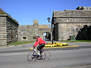
Fort Pickens is a pentagonal historic United States military fort on Santa Rosa Island in the Pensacola, Florida, area. It is named after American Revolutionary War hero Andrew Pickens. The fort was completed in 1834 and was one of the few forts in the South that remained in Union hands throughout the American Civil War. It remained in use until 1947. Fort Pickens is included within the Gulf Islands National Seashore, and as such, is administered by the National Park Service.

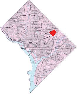
Northeast is the northeastern quadrant of Washington, D.C., the capital of the United States. It encompasses the area located north of East Capitol Street and east of North Capitol Street.

Colonel and Brevet Brigadier General Sylvanus Thayer also known as "the Father of West Point" was an early superintendent of the United States Military Academy at West Point and an early advocate of engineering education in the United States.

The Battle of Fort Stevens was an American Civil War battle fought July 11–12, 1864 in what is now Northwest Washington, DC, as part of the Valley Campaigns of 1864 between forces under Confederate Lieutenant General Jubal Early and Union Major General Alexander McDowell McCook. Although Early caused consternation in the Union government, reinforcements under Maj. Gen. Horatio G. Wright and the strong defenses of Fort Stevens minimized the military threat, and Early withdrew after two days of skirmishing and had attempted no serious assaults. The battle is noted for stories that US President Abraham Lincoln observed the fighting.
Fort Slocum, New York was a US military post which occupied Davids Island in the western end of Long Island Sound in the city of New Rochelle, New York from 1867 to 1965. The fort was named for Major General Henry W. Slocum, a Union corps commander in the American Civil War.

Neighborhoods in Washington, D.C., are distinguished by their history, culture, architecture, demographics, and geography. The names of 131 neighborhoods are unofficially defined by the D.C. Office of Planning. Neighborhoods can be defined by the boundaries of wards, historic districts, Advisory Neighborhood Commissions, civic associations, and business improvement districts (BIDs); these boundaries will overlap. The eight wards each elect a member to the Council of the District of Columbia and are redistricted every ten years.
Langdon, also referred to as, "South Woodridge", is a neighborhood located in Ward 5 of Northeast Washington, D.C. Historical surveys of D.C. recognize Langdon as a neighborhood dating back to at least 1903. Langdon is bounded by Montana Ave. NE to the west/southwest, New York Ave. NE to the south, Bladensburg Rd. NE to the southeast, South Dakota Ave. NE to the northeast, and Rhode Island Ave. NE to the north/northwest. Langdon is adjacent to the Northeast D.C. neighborhoods of Brentwood (west), Woodridge (east), Fort Lincoln (southeast), Gateway (south), and Brookland (north).

Fort Dupont Park is a 376-acre (1.52 km2) wooded park under the management of the National Park Service located in Washington, DC. The name of the park comes from the old Civil War earthwork fort that lies within the park. The fort was one of several designed to defend Washington from a Confederate attack during the Civil War. There are few remains of the actual fortifications.

Fort Bunker Hill was one of seven temporary earthwork forts part of the Civil War Defenses of Washington, D.C., during the Civil War built in the Northeast quadrant of the city at the beginning of the Civil War by the Union Army to protect the city from the Confederate Army. From west to east, the forts were: Fort Slocum, Fort Totten, Fort Slemmer, Fort Bunker Hill, Fort Saratoga, Fort Thayer and Fort Lincoln. Unlike other forts, today very little remains of the structure.
The 3rd Massachusetts Volunteer Heavy Artillery Regiment was a unit that served in the Union Army during the American Civil War. It was organized from already mustered unattached companies of heavy artillery raised for the defenses of the Massachusetts coast.

The Civil War Defenses of Washington were a group of Union Army fortifications that protected the federal capital city, Washington, D.C., from invasion by the Confederate States Army during the American Civil War. The sites of some of these fortifications are within a collection of National Park Service (NPS) properties that the National Register of Historic Places identifies as the Fort Circle. The sites of other such fortifications in the area have become parts of state, county or city parks or are located on privately owned properties. A trail connecting the sites is part of the Potomac Heritage Trail.

Battery Kemble Park is a park in Northwest Washington D.C., administered by the National Park Service.

The 150th Ohio Infantry Regiment, sometimes 150th Ohio Volunteer Infantry was an infantry regiment in the Union Army during the American Civil War.

Fort Totten Park is a Civil War memorial on the site of a Union fort. It is under the management of the National Park Service.

Fort Lincoln was one of seven temporary earthwork forts part of the Civil War Defenses of Washington, DC during the Civil War built in the Northeast quadrant of the city at the beginning of the Civil War by the Union Army to protect the city from the Confederate Army. From west to east, the forts were as follow: Fort Slocum, Fort Totten, Fort Slemmer, Fort Bunker Hill, Fort Saratoga, Fort Thayer and Fort Lincoln.

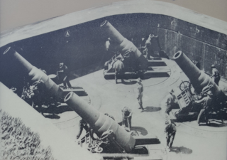
The Harbor Defenses of New York was a United States Army Coast Artillery Corps harbor defense command. It coordinated the coast defenses of New York City from 1895 to 1950, beginning with the Endicott program, some of which were located in New Jersey. These included both coast artillery forts and underwater minefields. The command originated circa 1895 as an Artillery District(s) and became the Coast Defenses of Eastern New York and Coast Defenses of Southern New York in 1913. Circa 1915 the Coast Defenses of Sandy Hook separated from the latter command. In 1925 the commands were renamed as Harbor Defense Commands, and in 1935 the Harbor Defenses of Eastern New York was almost entirely disarmed, although possibly retaining the minefield capability. The New York and Sandy Hook commands and the Harbor Defenses of Long Island Sound were unified as the Harbor Defenses of New York on 9 May 1942.
Fort Slocum was one of seven temporary earthwork forts, part of the Civil War Defenses of Washington, D.C., during the Civil War, built in the Northeast quadrant of the city after the beginning of the war by the Union Army to protect the city from the Confederate Army. From west to east, the forts were as follow: Fort Slocum, Fort Totten, Fort Slemmer, Fort Bunker Hill, Fort Saratoga, Fort Thayer and Fort Lincoln.
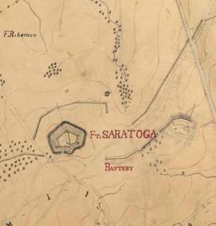
Fort Saratoga was one of seven temporary earthwork forts part of the Civil War Defenses of Washington, D.C., during the Civil War built in the Northeast quadrant of the city at the beginning of the Civil War by the Union Army to protect the city from the Confederate Army. From west to east, the forts were as follow: Fort Slocum, Fort Totten, Fort Slemmer, Fort Bunker Hill, Fort Saratoga, Fort Thayer and Fort Lincoln.. Unlike other forts, nothing remains of the structure.

Fort Slemmer sometimes called Battery Slemmer was one of seven temporary earthwork forts part of the Civil War Defenses of Washington, D.C., during the Civil War built in the Northeast quadrant of the city at the beginning of the Civil War by the Union Army to protect the city from the Confederate Army. From west to east, the forts were as follow: Fort Slocum, Fort Totten, Fort Slemmer, Fort Bunker Hill, Fort Saratoga, Fort Thayer and Fort Lincoln. Unlike other forts, today very little remains of the structure.