
The geography of France consists of a terrain that is mostly flat plains or gently rolling hills in the north and west and mountainous in the south and the east.

The Arctic Archipelago, also known as the Canadian Arctic Archipelago, is a group of islands north of the Canadian mainland.
Fremd Village-Padgett Island was a census-designated place (CDP) in Palm Beach County, Florida, United States. The population was 2,264 at the 2000 census.

The Icy Strait is a strait in the Alexander Archipelago in southeastern Alaska, at about 58°16′41″N 135°38′48″W. The strait separates Chichagof Island to the south and the Alaska mainland to the north. The strait is 64 km (40 mi) from its west side at the intersection of the Cross Sound and Glacier Bay to its east side at Chatham Strait and the Lynn Canal. The two largest islands in the strait are Pleasant Island and Lemesurier Island.

Burgeo-La Poile is a provincial electoral district for the House of Assembly of Newfoundland and Labrador, Canada. As of 2011, there are 7,527 eligible voters living within the district. The district was first created in 1995 following a reduction in the number of seats in the House of Assembly from 52 to 48, forming from the amalgamation of the former districts of La Poile and Burgeo-Bay D'Espoir.

Wellow is a village on the Isle of Wight. It is located about two miles east of Yarmouth in the northwest of the island. The name is believed to be of Jutish origin. Recently a proposal to erect a wind farm was rejected after a high-profile protest campaign. Located within Wellow are a small chapel, post office, vineyard and several farms including Mattingley and Manor Farm. The Hamstead trail runs through Wellow.

Tigalda Island is one of the Krenitzin Islands, a subgroup of the Fox Islands in the eastern Aleutian Islands, Alaska. Tigalda is located about 19 miles (31 km) east of Akutan Island, is 12 miles (19 km) long and has an area of about 35 square miles (91 km2). Tigalda is an Aleut name published by Captain Lutke (1836). It was called "Kagalga" by Captain Lt. Krenitzin and Lt. Levashev (1768). Tigalda Bay is situated on the north side of Tigalda. Father Veniaminov (1840) reported the existence of an Aleut village, which he called "Tigaldinskoe", of 91 people in 1833. Tigalda is uninhabited.
Pancake Rock is an island in the Fox Islands group in the eastern Aleutian Islands, Alaska. It is approximately 2,000 feet (610 m) across and is located about 1.9 miles (3.1 km) off the west coast of Umnak Island.
The island measuring 1.48 kilometres (0.92 mi) long and 2.06 kilometres (1.28 mi) wide.
Unalga Island is one of the Fox Islands subgroup of the Aleutian Islands of southwestern Alaska, United States. It lies just northeast of Unalaska Island and across Akutan Pass from Akutan Island to its northeast. It is the westernmost island in the Aleutians East Borough. Unalga Island has a land area of 11.004 square miles and is unpopulated.
The island is 6.7 kilometres (4.2 mi) long and 8.2 kilometres (5.1 mi) wide.

The Ottawa Islands are a group of uninhabited islands situated in the eastern edge of Canada's Hudson Bay. The group comprises 24 small islands, located at approximately 60N 80W. The main islands include Booth Island, Bronson Island, Eddy Island, Gilmour Island, J. Gordon Island, Pattee Island, and Perley Island. The highest point is on Gilmour Island, which rises to over 1,800 ft (550 m). Located a short distance off the northwest coast of Quebec's Ungava Peninsula, they, like the other coastal islands in Hudson Bay, were historically part of the Northwest Territories, and became part of the territory of Nunavut upon its creation in 1999.
WMXT, known as "102.1 The Fox", is a classic hits music-formatted radio station in the Florence, South Carolina, United States, market.
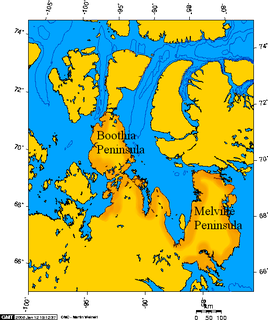
Murchison Promontory is a peninsula in northern Canada that is the northernmost point on mainland Canada and on the mainland of North America; it is also one of the Extreme points of Earth.
KSOR is a National Public Radio member station licensed to Ashland, Oregon. The station is owned by Southern Oregon University, and is an affiliate of Jefferson Public Radio. It is the flagship of JPR's "Classics & News" service, consisting of news and classical music programming.
Fox Island River-Point au Mal is a designated place in the Canadian province of Newfoundland and Labrador, located northwest of Stephenville. It had a population of 198 in the Canada 2006 Census.

Irish Town is an unincorporated community in Butte County, California. It lies at an elevation of 2,270 feet.

Fox Point is a settlement in Newfoundland and Labrador.

Baudette Air Force Station is a closed United States Air Force General Surveillance Radar station. It is located 3.1 miles (5.0 km) south-southwest of Baudette, Minnesota. It was closed in 1979.

Hat Island is a census-designated place (CDP) in Snohomish County, Washington, United States. The population was 41 at the 2010 census. The CDP occupies an island in Possession Sound called Hat Island, also known as Gedney Island.


