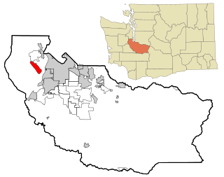
Fox Island is an island and census-designated place (CDP) in Pierce County, Washington, United States, in Puget Sound. It is located approximately 5 miles (8 km) from Gig Harbor. The island was named Fox by Charles Wilkes during the United States Exploring Expedition, to honor J.L. Fox, an assistant surgeon on the expedition. The population was 3,633 at the 2010 census.
Division No. 1, Subdivision M is an unorganized subdivision on the Avalon Peninsula in Newfoundland and Labrador, Canada in Division 1. It contains the unincorporated communities of Emerald Vale, Goulds Road, Juniper Stump, Mahers and Turks Water.

Avalon is a federal electoral district on Newfoundland Island in Newfoundland and Labrador, Canada. It has been represented in the House of Commons of Canada since 2004.
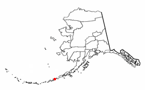
The Fox Islands are a group of islands in the eastern Aleutian Islands of the U.S. state of Alaska. The Fox Islands are the closest to mainland North America in the Aleutian chain, and just east of Samalga Pass and the Islands of Four Mountains group.
Sanak Island is an island in the Fox Islands group of the Aleutian Islands in the U.S. state of Alaska. It is located at 54°25′47″N162°42′32″W.

Burgeo-La Poile is a provincial electoral district for the House of Assembly of Newfoundland and Labrador, Canada. As of 2011, there are 7,527 eligible voters living within the district. The district was first created when Newfoundland joined confederation in 1949 as Burgeo and La Poile, and existed until 1975. It was recreated in 1995 following a reduction in the number of seats in the House of Assembly from 52 to 48, forming from the amalgamation of the former districts of La Poile and Burgeo-Bay D'Espoir.

Otter Island is a small island located 6 miles (9.7 km) southwest of Saint Paul Island, Alaska, in the Bering Sea. It is a member of the Pribilof Islands. Its land area is 165.21 acres (0.6686 km²) and there is no resident population. The highest point on the island is 935 feet (285 m) above sea level. The island is closed to hunting.
The Delarof Islands are a group of small islands at the extreme western end of the Andreanof Islands group in the central Aleutian Islands, Alaska. The Delarofs consist of 11 named islands: Amatignak, Gareloi, Ilak, Kavalga (Qavalĝa), Ogliuga (Aglaga), Skagul (Sxaĝulax̂), the Tags (Tagachaluĝis), Tanadak (Tanaadax̂), Ugidak (Qagan-tanax̂), Ulak, and Unalga (Unalĝa).

Sedanka Island is an island in the Fox Islands group of the eastern Aleutian Islands, Alaska. It is 10.3 miles (16.6 km) long and is situated off the northeast coast of Unalaska Island. It has a land area of 39.889 square miles (103.31 km2) and no permanent population.

Fortune Bay is a fairly large natural bay located in the Gulf of St. Lawrence on the south coast of Newfoundland, Canada. The Bay is bounded by Point Crewe on the Burin Peninsula and Pass Island at the entrance to Hermitage Bay to the northwest for a distance of 56 kilometers. The bay extends in a northeast direction for 105 kilometers ending at Terrenceville.
Ramea Island, Newfoundland and Labrador was a small place of 30 families in 1864. Ramea Island is a group of five islands, Northwest Island, Great Island, Middle Island, Harbour Island and Southwest Island. In the early 1940s, all inhabitants moved to Northwest Island and formed the town of Ramea.

WKAD is a radio station broadcasting a sports format. Licensed to Harrietta, Michigan, and serving the Cadillac market, it first began broadcasting in 2003. WKAD features programming from Fox Sports Radio. WKAD carries the Detroit Tigers, Detroit Red Wings, Michigan Wolverines Football and Basketball, and Cadillac Viking Sports.

Nanisivik Mine was a zinc-lead mine in the company town of Nanisivik, Nunavut, 750 km (470 mi) north of the Arctic Circle on Baffin Island. It was Canada's first mine in the Arctic. The mine first opened on 15 October 1976 and permanently closed in September 2002 due to low metal prices and declining resources. Mine reclamation began in April 2003 It was one of the most northerly mines in the world.
West Island is an island in Fairhaven, Massachusetts, United States, on Buzzards Bay. Approximately two-thirds of the island is forest. Water and sewage restrictions have limited its growth. Fairhaven is located in southeastern Bristol County, near the city of New Bedford.

Cartwright Air Station is a closed General Surveillance Radar station. It is located 145.2 miles (233.7 km) east-northeast of CFB Goose Bay, Newfoundland and Labrador. It was closed in 1968.
Bonalds Island is an island off the south coast of Newfoundland, Canada. Fox Island Harbour separates it from the mainland. The Shag Islands lie to the east and the larger Bear Island to the northwest. Its highest point is about 90 metres above sea level.
The Shag Islands are a small group of islands in the southern part of Coppett Harbour, off the south coast of Newfoundland, Canada. They lie to the east of Bonalds Island. The southernmost island, Shag Island, is described as "a conspicuous white rock, 12.8m high".
Coates Castle SSSI is a 7.7-hectare (19-acre) biological Site of Special Scientific Interest west of Pulborough in West Sussex.


