Route 27 is a state highway in New Jersey, United States. It runs 38.53 mi (62.01 km) from U.S. Route 206 in Princeton, Mercer County northeast to an interchange with Route 21 and Broad Street in Newark, Essex County. The route passes through many communities along the way, including New Brunswick, Metuchen, Rahway, and Elizabeth. Route 27 is a two- to four-lane undivided highway for most of its length, passing through a variety of urban and suburban environments. It intersects many roads along the way, including Route 18 in New Brunswick, Interstate 287 in Edison, the Garden State Parkway in Woodbridge Township, Route 35 in Rahway, Route 28 in Elizabeth, and U.S. Route 22 in Newark. Route 27 crosses the Raritan River on the Albany Street Bridge, which connects Highland Park on the east with New Brunswick on the west.

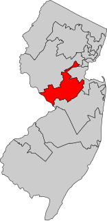
Middlesex County is a county located in north- central New Jersey, United States. In 2017 the Census Bureau estimated the county's population at 842,798, making it the state's second-most populous county, an increase of 4.1% from 809,858 in the 2010 census. Middlesex is part of the New York metropolitan area, and its county seat is New Brunswick. The center of population of the state of New Jersey is located in Middlesex County, in East Brunswick Township, just east of the New Jersey Turnpike. The 2000 Census showed that the county ranked 63rd in the United States among the highest-income counties by median household. The Bureau of Economic Analysis ranked the county as having the 143rd-highest per capita income of all 3,113 counties in the United States as of 2009. Middlesex County holds the nickname, "The Greatest County in the Land".

Route 26 is a state highway in New Jersey, United States, running 2.54 miles (4.09 km) along Livingston Avenue from U.S. Route 1 (US 1) in North Brunswick Township northeast to Nassau Street at the border of New Brunswick. Prior to the 1953 renumbering, the route continued southwest along US 1 to Trenton. Livingston Avenue inside New Brunswick, southwest of Suydam Street, is the 1.08-mile (1.74 km) County Route 691 (CR 691). The 0.39 miles (0.63 km) from Suydam Street to its end at George Street is part of State Route 171, also maintained by Middlesex County.

South Brunswick is a township in Middlesex County, New Jersey, United States. As of the 2010 United States Census, the township's population was 43,417, reflecting an increase of 5,683 (+15.1%) from the 37,734 counted in the 2000 Census, which had in turn increased by 11,942 (+46.3%) from the 25,792 counted in the 1990 Census.

Franklin Township is a township in Somerset County, New Jersey, United States. As of the 2010 United States Census, the township's population was 62,300, reflecting an increase of 11,397 (+22.4%) from the 50,903 counted in the 2000 Census, which had in turn increased by 8,123 (+19.0%) from the 42,780 counted in the 1990 Census.

Route 91 is a 2.26-mile (3.64 km) long spur state highway in Middlesex County, New Jersey. The route runs as a spur of U.S. Route 1 along Jersey Avenue in North Brunswick Township to Van Dyke Avenue in the city of New Brunswick. At Van Dyke Avenue, Route 91 ends as a state route, and Jersey Avenue continues as County Route 693 to New Jersey Route 27 in the center of New Brunswick. The mainline of Route 91 only ends at U.S. Route 1 southbound, so the 0.37-mile (0.60 km) long connector constructed from U.S. Route 1 northbound is designated as Route 91 Connector.

North Brunswick is a township in Middlesex County, New Jersey, United States. At the 2010 United States Census, the population was 40,742, reflecting an increase of 4,455 (+12.3%) from the 36,287 counted in the 2000 Census, which had in turn increased by 5,000 (+16.0%) from the 31,287 counted in the 1990 Census. Located south of the city of New Brunswick, North Brunswick was named for its earlier-established neighbor, South Brunswick, New Jersey. The "Brunswick" comes from New Brunswick, which was named after the German city of Braunschweig or for the British royal House of Brunswick. North and South Brunswick, in turn, became the namesakes for East Brunswick. Alternatively, the city gets its name from King George II of Great Britain, the Duke of Brunswick-Lüneburg.
Central Jersey is the central region of the U.S. state of New Jersey. The designation of central New Jersey with a distinct toponym is a colloquial one rather than an administrative one, with no official definition and even a contentious taxonomic existence.

Route 92 was a 6.7-mile (10.8 km) proposed branch of the New Jersey Turnpike that would have run from west to east, beginning at U.S. Route 1 just north of Ridge Road in South Brunswick Township, east along Route 32, to Exit 8A in Monroe Township. Route 92 was also assigned in the 1953 renumbering and by the late 1950s it was named the Princeton–Hightstown Bypass, a freeway planned to connect the Somerset Freeway in Montgomery Township, with Route 33 in East Windsor Township. In 1987, the planned Route 92 was truncated to only run east from U.S. Route 1 near Kingston. New plans were announced in 1994, this time running to US 1 near Princeton. After public hearings found opposition was still strong, the planned route was truncated to a much shorter bypass of Hightstown only and numbered Route 133. Construction on the road, the first project awarded under New Jersey's modified Design-build program, began on September 20, 1996 and was opened November 30, 1999.
New Jersey's Twelfth Congressional district is represented by Democrat Bonnie Watson Coleman. The district is known for its research centers and educational institutions such as Princeton University, Rider University, The College of New Jersey, Institute for Advanced Study, Johnson & Johnson and Bristol-Myers Squibb.
Six Mile Run is an unincorporated community and census-designated place (CDP) located in Franklin Township, in Somerset County, New Jersey, United States. As of the 2010 United States Census, the CDP's population was 3,184.
County Route 535, abbreviated CR 535, is a county highway in the U.S. state of New Jersey. The highway extends 31.75 miles (51.10 km) from Logan Avenue, at the boundary between Trenton and Hamilton Township in Mercer County to the intersection of Main Street, Raritan Street and Washington Road in Sayreville in Middlesex County.

County Route 527, abbreviated CR 527, is a county highway in the U.S. state of New Jersey. The highway extends 84.86 mi (136.57 km) from Main Street in Toms River Township to Pompton Avenue in Cedar Grove. It passes through more counties (six) than any other county route in New Jersey. CR 527 is also the second longest 500-series county route in New Jersey after Route 519. It was first given the number 527 in 1954.
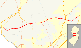
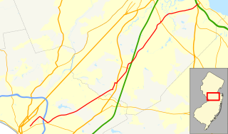
County Route 518, abbreviated CR 518, is a county highway in the U.S. state of New Jersey. The highway extends 20.58 miles (33.12 km) from Route 165 in Lambertville to Lincoln Highway in Franklin Township. It is also known as the Georgetown Franklin Turnpike.
The Brunswicks are a group of four municipalities in Middlesex County, New Jersey, all of which have the word Brunswick in their name. New Brunswick, New Jersey, the first formed of the four, was named in 1730 after the British royal House of Brunswick. The name is also attributed to the German city of Braunschweig, formerly translated in English as Brunswick

The Six Mile Run Reformed Church is in the Six Mile Run section of Franklin Township, Somerset County, New Jersey. It takes its name from Six Mile Run, a tributary of the Millstone River that flows through the area.
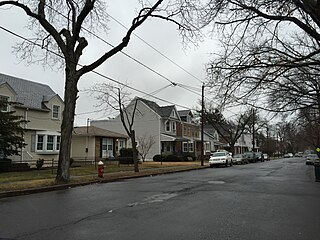
Slackwood is an unincorporated community located within Lawrence Township in Mercer County, New Jersey, United States. The area is named for the owners of the land that was subdivided into the neighborhood today, Joseph Slack and William Wood. The neighborhood was first developed in 1890 as the first suburban development in the reconfigured Lawrence Township. Its location between Princeton Pike and Brunswick Pike allowed for an easy walk to nearby Trenton factories. Today, most of the homes in Slackwood are still small bungalows with some businesses along Princeton and Brunswick Pikes. The neighborhood is bounded by the two highways on the northwest and southeast, Slackwood Park and forest on the southwest, and Shabakunk Creek and Park on the northeast.
Brookview is an unincorporated community located within East Brunswick Township in Middlesex County, New Jersey, United States. The settlement is located along Church Lane at the former Newark–Trenton Fast Line right-of-way, now a PSE&G transmission line corridor. The Brookview Volunteer Fire Company, established in 1952, takes its name from the settlement.