Boardsports are sports that are played with some sort of board as the primary equipment. These sports take place on a variety of terrain, from paved flat-ground and snow-covered hills to water and air. Most boardsports are considered action sports or extreme sports, and thus often appeal to youth. A large proportion of youth partaking in these sports, together with aesthetic damage to property from sports like skateboarding, has led to many board sports being marginalized by the greater world of sports in the past. However, many board sports are ever-more frequently gaining mainstream recognition, and with this recognition have enjoyed wider broadcast, sponsorship and inclusion in institutional sporting events, including the Olympic Games.
Atmospheric pressure, sometimes also called barometric pressure, is the pressure within the atmosphere of Earth. The standard atmosphere is a unit of pressure defined as 1013.25 mbar (101325 Pa), equivalent to 760 mmHg (torr), 29.9212 inches Hg, or 14.696 psi. The atm unit is roughly equivalent to the mean sea-level atmospheric pressure on Earth, that is, the Earth's atmospheric pressure at sea level is approximately 1 atm.

Mean sea level (MSL) is an average level of the surface of one or more of Earth's oceans from which heights such as elevation may be measured. MSL is a type of vertical datum – a standardised geodetic datum – that is used, for example, as a chart datum in cartography and marine navigation, or, in aviation, as the standard sea level at which atmospheric pressure is measured to calibrate altitude and, consequently, aircraft flight levels. A common and relatively straightforward mean sea-level standard is the midpoint between a mean low and mean high tide at a particular location.
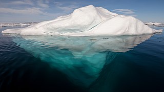
An iceberg is a large piece of freshwater ice that has broken off a glacier or an ice shelf and is floating freely in open (salt) water. Another name for iceberg is "ice mountain". Small bits of disintegrating icebergs are called "growlers" or "bergy bits".

A superstructure is an upward extension of an existing structure above a baseline. This term is applied to various kinds of physical structures such as buildings, bridges, or ships having the degree of freedom zero. The word "superstructure" is a combination of the Latin prefix, super with the Latin stem word, structure.

An ice shelf is a thick suspended platform of ice that forms where a glacier or ice sheet flows down to a coastline and onto the ocean surface. Ice shelves are only found in Antarctica, Greenland, Canada, and the Russian Arctic. The boundary between the floating ice shelf and the anchor ice that feeds it is called the grounding line. The thickness of ice shelves can range from about 100 m (330 ft) to 1,000 m (3,300 ft).

The metacentric height (GM) is a measurement of the initial static stability of a floating body. It is calculated as the distance between the centre of gravity of a ship and its metacentre. A larger metacentric height implies greater initial stability against overturning. The metacentric height also influences the natural period of rolling of a hull, with very large metacentric heights being associated with shorter periods of roll which are uncomfortable for passengers. Hence, a sufficiently, but not excessively, high metacentric height is considered ideal for passenger ships.

The Royal Sovereign class was a group of eight pre-dreadnought battleships built for the Royal Navy in the 1890s. The ships spent their careers in the Mediterranean, Home and Channel Fleets, sometimes as flagships, although several were mobilised for service with the Flying Squadron in 1896 when tensions with the German Empire were high following the Jameson Raid in South Africa. Three ships were assigned to the International Squadron formed when Greek Christians rebelled against the Ottoman Empire′s rule in Crete in 1897–1898.
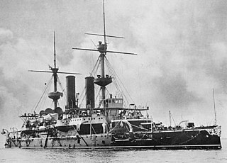
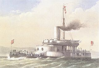
HMS Hood was a modified Royal Sovereign-class pre-dreadnought battleship built for the Royal Navy in the early 1890s. She differed from the other ships of the class in that she had cylindrical gun turrets instead of barbettes and a lower freeboard. She served most of her active career in the Mediterranean Sea, where her low freeboard was less of a disadvantage. The ship was placed in reserve in 1907 and later became the receiving ship at Queenstown, Ireland. Hood was used in the development of anti-torpedo bulges in 1913 and was scuttled in late 1914 to act as a blockship across the southern entrance of Portland Harbour after the start of World War I.

In geology and physical geography, a plateau, also called a high plain or a tableland, is an area of a highland, usually consisting of relatively flat terrain, that is raised significantly above the surrounding area, often with one or more sides with steep slopes. Plateaus can be formed by a number of processes, including upwelling of volcanic magma, extrusion of lava, and erosion by water and glaciers. Plateaus are classified according to their surrounding environment as intermontane, piedmont, or continental.

An ice volcano is a conical mound of ice formed over a terrestrial lake via the eruption of water and slush through an ice shelf. The process is wave-driven, with wind providing the energy for the waves to cut through the ice and form the volcanoes. After being ejected into the atmosphere, the liquid water and slush freeze and fall back to the surface, growing the formation. Ice may also be erupted. The phenomenon is most often observed along the southern coast of Lake Erie and Lake Ontario, when the temperature is below freezing and the wind blows onshore with a velocity of at least 25 mph (40 km/h). They are known to reduce coastal erosion there. The formations are temporary — they are frequently destroyed by storms and warm weather, and once the lake wholly freezes over, eruptions are no longer possible.
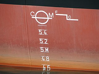
The waterline is the line where the hull of a ship meets the surface of the water. Specifically, it is also the name of a special marking, also known as an international load line, Plimsoll line and water line, that indicates the draft of the ship and the legal limit to which a ship may be loaded for specific water types and temperatures in order to safely maintain buoyancy, particularly with regard to the hazard of waves that may arise. Varying water temperatures will affect a ship's draft; because warm water is less dense than cold water, providing less buoyancy. In the same way, fresh water is less dense than salinated or seawater with the same lessening effect upon buoyancy.

A breastwork monitor was a type of ship originated by Sir Edward Reed, the Chief Constructor of the Royal Navy between 1863 and 1870. The term "monitor" was directly derived from the American ship of that name, USS Monitor designed by John Ericsson which served in the American Civil War. The American ships were very stable, and difficult to damage by gunfire, because of their very low freeboard. This, however, caused them to behave, some said, as a "half-tide rock", with the ever-present risk of being swamped in a sea should water gain access to the interior through hatches, turret bases or other openings in the deck.
HMS Glatton was a breastwork monitor which served in the Victorian Royal Navy.

A pressure ridge develops in an ice cover as a result of a stress regime established within the plane of the ice. Within sea ice expanses, pressure ridges originate from the interaction between floes, as they collide with each other. Currents and winds are the main driving forces, but the latter are particularly effective when they have a predominant direction. Pressure ridges are made up of angular ice blocks of various sizes that pile up on the floes. The part of the ridge that is above the water surface is known as the sail; that below it as the keel. Pressure ridges are the thickest sea ice features and account for about one-half of the total sea ice volume. Stamukhi are pressure ridges that are grounded and that result from the interaction between fast ice and the drifting pack ice.

Metres above the Adriatic is the vertical datum used in Austria, in the former Yugoslavian states of Slovenia, Croatia, Bosnia-Hercegovina, Serbia, Montenegro, Macedonia, Kosovo, as well as in Albania to measure elevation, referring to the average water level of the Adriatic Sea at the Sartorio mole in the Port of Trieste.