
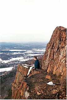
Mount Holyoke, a traprock mountain, elevation 935 feet (285 m), is the western-most peak of the Holyoke Range and part of the 100-mile (160 km) Metacomet Ridge. The mountain is located in the Connecticut River Valley of western Massachusetts, and is the namesake of nearby Mount Holyoke College. The mountain is located in the towns of Hadley and South Hadley, Massachusetts. It is known for its historic summit house, auto road, scenic vistas, and biodiversity. The mountain is crossed by the 110-mile (180 km) Metacomet-Monadnock Trail and numerous shorter trails. Mount Holyoke is the home of J.A. Skinner State Park which is accessible from Route 47 in Hadley, Massachusetts.

The Pioneer Valley is the colloquial and promotional name for the portion of the Connecticut River Valley that is in Massachusetts in the United States. It is generally taken to comprise the three counties of Hampden, Hampshire, and Franklin. The lower Pioneer Valley corresponds to the Springfield, Massachusetts metropolitan area, the region's urban center, and the seat of Hampden County. The upper Pioneer Valley region includes the smaller cities of Northampton and Greenfield, the county seats of Hampshire and Franklin counties, respectively.

Mount Tom, 1,202 feet (366 m), is a steep, rugged traprock mountain peak on the west bank of the Connecticut River 4.5 miles (7 km) northwest of downtown Holyoke, Massachusetts. The mountain is the southernmost and highest peak of the Mount Tom Range and the highest traprock peak of the 100-mile (160 km) long Metacomet Ridge. A popular outdoor recreation resource, the mountain is known for its continuous line of cliffs and talus slopes visible from the south and west, its dramatic 1,100-foot (340 m) rise over the surrounding Connecticut River Valley, and its rare plant communities and microclimate ecosystems.

Mount Watatic is a 1,832-foot (558 m) monadnock located just south of the Massachusetts–New Hampshire border, in the United States, at the southern end of the Wapack Range of mountains. It lies within Ashburnham and Ashby, in Massachusetts, and New Ipswich, in New Hampshire; the 22 miles (35 km) Wapack Trail and the 92-mile (148 km) Midstate Trail both cross the mountain. The Yellow Arrow trail is 1.1 mile. Public parking for a half-hour hike to the summit is located on Massachusetts Route 119.

Joseph Allen Skinner State Park is a state-owned, public recreation area located in the towns of Hadley and South Hadley in the Connecticut River Valley of western Massachusetts. The state park surrounds Mount Holyoke, the westernmost peak of the Mount Holyoke Range. At the summit is the historic Prospect House, an old hotel first opened in 1851. The park is managed by the Massachusetts Department of Conservation and Recreation.
The Metacomet-Monadnock Trail is a 114-mile-long (183 km) hiking trail that traverses the Metacomet Ridge of the Pioneer Valley region of Massachusetts and the central uplands of Massachusetts and southern New Hampshire. Although less than 70 miles (110 km) from Boston and other large population centers, the trail is considered remarkably rural and scenic and includes many areas of unique ecologic, historic, and geologic interest. Notable features include waterfalls, dramatic cliff faces, exposed mountain summits, woodlands, swamps, lakes, river floodplain, farmland, significant historic sites, and the summits of Mount Monadnock, Mount Tom and Mount Holyoke. The Metacomet-Monadnock Trail is maintained largely through the efforts of the Berkshire Chapter of the Appalachian Mountain Club (AMC). Much of the trail is a portion of the New England National Scenic Trail.

Connecticut River Greenway State Park is a protected environment with public recreation features that consists of separate state land holdings, including open spaces, parks, scenic vistas, and archaeological and historic sites, along the Connecticut River in the Pioneer Valley of western Massachusetts. The state park includes critical wildlife and plant habitat as well as areas providing public access to the river in its run across the state and is intertwined with other protected land including farmland under state-held agricultural preservation restrictions, municipal and conservation land trust holdings, and state and national wildlife refuges.

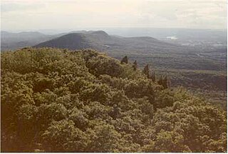
Mount Nonotuck, 827 feet (252 m), is the northernmost peak of the Mount Tom Range of traprock mountains located in the Connecticut River Valley of Massachusetts and part of the larger Metacomet Ridge which stretches from Long Island Sound to nearly the Vermont border. Rugged and considered scenic, the peak rises steeply from the river valley 700 feet (210 m) below. It is located within the town of Holyoke.
The Mount Tom Range is a traprock mountain range located in the Connecticut River Valley of Massachusetts. It is part of the Metacomet Ridge that extends from Long Island Sound near New Haven, Connecticut, north through the Connecticut River Valley of Massachusetts to nearly the Vermont border. A popular outdoor recreation resource, the range is known for its continuous west facing cliffs and its rugged, scenic character. It is also notable for its unique microclimate ecosystems and rare plant communities, as well as significant historic sites, such as the ruins of the 18th century Eyrie House located on Mount Nonotuck.

The Metacomet Ridge, Metacomet Ridge Mountains, or Metacomet Range of southern New England is a narrow and steep fault-block mountain ridge known for its extensive cliff faces, scenic vistas, microclimate ecosystems, and rare or endangered plants. The ridge is an important recreation resource located within 10 miles (16 km) of more than 1.5 million people, offering four long-distance hiking trails and over a dozen parks and recreation areas, including several historic sites. It has been the focus of ongoing conservation efforts because of its natural, historic, and recreational value, involving municipal, state, and national agencies and nearly two dozen non-profit organizations.

The Holyoke Range or Mount Holyoke Range is a traprock mountain range located in the Connecticut River Valley of Massachusetts. It is a sub-range of the narrow, linear Metacomet Ridge that extends from Long Island Sound near New Haven, Connecticut north through the Connecticut River Valley of Massachusetts to the Vermont border. A popular hiking destination, the range is known for its anomalous east–west orientation, high ledges and its scenic character. It is also notable for its unique microclimate ecosystems and rare plant communities, as well as significant historic sites, such as the Mount Holyoke Summit House and the Horse Caves.

East Mountain is a traprock mountain ridge located in the Connecticut River Valley of Massachusetts. It is part of the narrow, linear Metacomet Ridge that extends from Long Island Sound near New Haven, Connecticut, north through the Connecticut River Valley of Massachusetts to the Vermont border. East Mountain is known for its extensive scenic cliffs, unique microclimate ecosystems, and rare plant communities. It is traversed by the 110-mile (180 km) Metacomet-Monadnock Trail.

Mount Norwottuck or Mount Norwottock, 1,106 feet (337 m) above sea level, is the highest peak of the Holyoke Range of traprock mountains located in the Connecticut River Valley of Massachusetts and part of the greater Metacomet Ridge which stretches from Long Island Sound to nearly the Vermont border. The peak rises steeply from the valley 1,000 feet (300 m) below and offers sweeping views of the surrounding countryside. It is located within the towns of Amherst and Granby, Massachusetts.
Bare Mountain, 1,014 feet (309 m) above sea level, is a prominent peak of the Holyoke Range of traprock mountains located in the Connecticut River Valley of Massachusetts, and part of the greater Metacomet Ridge that stretches from Long Island Sound to nearly the Vermont border. The peak rises steeply from the river valley 1,000 feet (300 m) below; its bald summit offers sweeping views. Bare Mountain is located within the towns of Amherst and South Hadley, Massachusetts. Part of its northeastern flanks are in Hadley and part of its southern flanks are in Granby. It is traversed by the 110-mile (180 km) Metacomet-Monadnock Trail.

The New England National Scenic Trail (NET) is a National Scenic Trail in southern New England, which includes most of the three single trails Metacomet-Monadnock Trail, Mattabesett Trail and Metacomet Trail. After the Metacomet-Monadnock-Mattabesett trail system, the trail is sometimes called the Triple-M Trail. The 215-mile (346 km) route extends through 41 communities from Guilford, Connecticut at Long Island Sound over the Metacomet Ridge, through the highlands of the Pioneer Valley of Massachusetts, to the New Hampshire state border. This includes a now (2013) complete connector trail from the southernmost location of the Mattabesett Trail to the sea and a deviation of the Metacomet-Monadnock Trail in Massachusetts, to lead the trail through state-owned land instead of largely unprotected land.
The Robert Frost Trail is a 47-mile (76 km) long footpath that passes through the eastern Connecticut River Valley of Massachusetts. The trail runs from the Connecticut River in South Hadley, Massachusetts to Ruggles Pond in Wendell State Forest, through both Hampshire and Franklin County and includes a number of scenic features such as the Holyoke Range, Mount Orient, Puffer's Pond, and Mount Toby. The trail is named after the poet Robert Frost, who lived and taught in the area from 1916 to 1938.

Mount Orient, 955 feet, is a south-facing high point on an upland plateau overlooking the Connecticut River Valley in Pelham, Massachusetts. Although the summit is wooded, a lower, south-facing ledge of exfoliating metamorphic rock provides views of the Holyoke Range and the east-central Pioneer Valley. Both the Metacomet-Monadnock Trail and the Robert Frost Trail (Massachusetts) traverse Mount Orient. The ledge is a popular hiking destination among college students and residents of nearby Amherst. Easiest access is via the Amethyst Brook Conservation Area parking lot on Pelham Road in east Amherst.
Mount Holyoke Range State Park is a state-owned, public recreation area encompassing the eastern half of the Holyoke Range in the Pioneer Valley region of Massachusetts. The state park is adjacent to J. A. Skinner State Park, which occupies the western half of the Holyoke Range. Both are managed by the Massachusetts Department of Conservation and Recreation.
Little Tom Mountain is a 73-acre (300,000 m2) nature preserve in Holyoke, Massachusetts and is managed by the Trustees of Reservations. The land was purchased in 2002 by a joint effort of the Trustees of Reservations, U.S. Fish and Wildlife Service, the Department of Conservation and Recreation, and the Holyoke Boys & Girls Club from the holders of the former Mt. Tom Ski area. It is not yet open to the public due to a nearby quarry operation, but expects to be open by 2012.
Long Mountain, 920 feet (280 m) feet above sea level, is a traprock mountain of the Holyoke Range, part of the greater Metacomet Ridge which stretches from Long Island Sound to nearly the Vermont border. The mountain rises steeply from the surrounding landscape 600 feet (180 m) below and consists of five distinct peaks, from east to west: 685 feet (209 m), 775 feet (236 m), 795 feet (242 m), 920 feet (280 m), the high point, and the eastern summit, 906 feet (276 m). It is located within the towns of Amherst and Granby, Massachusetts. The 110-mile (180 km) Metacomet-Monadnock Trail and the 47-mile (76 km) Robert Frost Trail traverse the mountain. The Holyoke Range continues to the west as Mount Norwottuck and to the east as Harris Mountain.