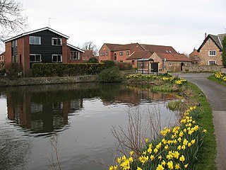
Dadford is a hamlet in the parish of Stowe, north Buckinghamshire, England.

Filgrave is a hamlet in the unitary authority area of the City of Milton Keynes, Buckinghamshire, England. It is about 3 miles (4.8 km) north of Newport Pagnell and 6 miles (9.7 km) north-east of Central Milton Keynes.

Wooburn is a large village in Buckinghamshire, England. It is located off the A4094 road between Wooburn Green and Bourne End in the very south of the county near the River Thames, about two miles south west of Beaconsfield and four miles east of Marlow. Wooburn is one of the two principal settlements within Wooburn, a civil parish in Wycombe district.

Combe Raleigh is a village and civil parish in the county of Devon, England. The village lies about 1.5 miles north of the town of Honiton, and the parish is surrounded, clockwise from the north, by the parishes of Luppitt, Honiton, Awliscombe and Dunkeswell.

Foxton is a small village in County Durham, England. It is situated to the north-west of Stockton-on-Tees, near Stillington.
Eype Mouth is a natural break in a line of sea cliffs on the Jurassic Coast World Heritage Site in west Dorset on the south coast of England. The small River Eype drains into the sea at this point. Eype means 'a steep place' in Old English. The village of Eype lies just upstream of the rivermouth, which is reached by a single narrow lane which runs down through Lower Eype to a shingle beach with car park.
Grafton is a village and civil parish in Herefordshire, England. The population of this civil parish was 258 at the 2011 census. The parish includes the villages of Grafton and Bullinghope, and is immediately to the south of Hereford city.

Dinedor is a hill, village and civil parish in Herefordshire, England. Dinedor is situated 5 km (3.1 mi) south east of Hereford. The hilltop is the site of Dinedor Camp, an Iron Age fort.

Easby is a village and civil parish in Hambleton District of North Yorkshire, England. It lies approximately 2 miles (3.2 km) south-east of Great Ayton. The larger village of Low Easby lies 0.3 miles (480 m) down the road, but neither have any amenities, only a postbox.

Finchdean is a rural hamlet in the East Hampshire district of Hampshire, England. It lies on the Hampshire/West Sussex border, 1.7 miles (2.7 km) east of Horndean.
Frogmore is a small suburban village in the northeast of the civil parish of Yateley in the county of Hampshire, England.
East Tytherley is a small village in Hampshire, England.

Forcett is a village in the Richmondshire district of North Yorkshire, England. It lies near the border with County Durham, on the B6274 road about 8 miles south of Staindrop. Nearby villages include Eppleby, Caldwell and Aldbrough.
Gosford and Water Eaton is a civil parish in the Cherwell district of the county of Oxfordshire, England. It is north of the city of Oxford and is crossed nearby by two major roads for, or by-passing, the city. The parish contains the village of Gosford and the hamlet of Water Eaton and as at the 2011 census had 1373 people resident across its 8.75 km2.

Fiddleford is a hamlet in the county of Dorset in southern England. Fiddleford is situated between Sturminster Newton and Okeford Fitzpaine in the North Dorset administrative district. It was founded by an English nobleman named Fitela, and the aforementioned ford is over the River Stour.

Ferrensby is a village and civil parish in the Harrogate district of North Yorkshire, England. The population of the civil parish at the 2011 census was 187. It is about 3 miles (4.8 km) north-east of Knaresborough and near the A1(M) motorway. Nearby attractions include a balloon centre and a maze.

Fadmoor is a village and civil parish in North Yorkshire, England. It is on the border of the North York Moors and 2 miles (3.2 km) north of Kirkbymoorside.

Dacre Beck is a small river in Cumbria, England.
Darby Green is a village in the parish of Yateley, North East Hampshire, England. The electoral ward of Frogmore and Darby Green is separated from the rest of the parish by a small gap around Clarks Farm, until recently a composting farm in the mushroom producing industry. The ward has a boundary shared with Blackwater, which is one part of the Civil Parish of Hawley.
Enborne Row is a hamlet in Berkshire, England, located on the county's border with Hampshire. The hamlet is within the civil parish of Enborne. The settlement lies next to the A34 road, and is located approximately 3 miles (4.8 km) south-west of Newbury. The name Enborne comes from Old English and means duck stream.


