Götavirke

Last updated
Remains of Gotavirke at the farm of Hageby, in Ostergotland. On the image the remains of the dyke run from the bottom right up towards the trees and parallel with the road Gotavirke.jpg
Remains of Götavirke at the farm of Hageby, in Östergötland. On the image the remains of the dyke run from the bottom right up towards the trees and parallel with the road

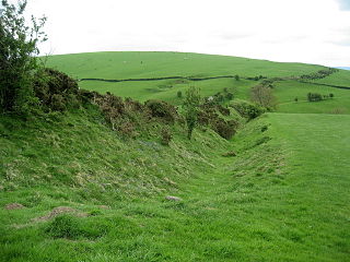
Götavirke (Geatish Dyke) are the remains of two parallel defensive walls going from north to south between the villages of Västra Husby ( 58°29′N16°10′E / 58.483°N 16.167°E / 58.483; 16.167 ) and Hylinge ( 58°28′N16°10′E / 58.467°N 16.167°E / 58.467; 16.167 ) in Söderköping Municipality, Östergötland, Sweden. The walls cover the distance between the lakes Asplången ( 58°30′N16°08′E / 58.500°N 16.133°E / 58.500; 16.133 ) and Lillsjön ( 58°28′N16°10′E / 58.467°N 16.167°E / 58.467; 16.167 ). North of Asplången there are remains of several ancient hill forts that may have been part of the defensive line. South of Lake Lillsjön, the terrain is so hard to pass that it hardly needed any defenses.

Västra Husby Place in Östergötland, Sweden

Västra Husby is a locality situated in Söderköping Municipality, Östergötland County, Sweden with 486 inhabitants in 2010. There are many places in Sweden called Husby, making it easily mixed up with the suburb in the capital Stockholm.

Söderköping Municipality Municipality in Östergötland County, Sweden

Söderköping Municipality is a municipality in Östergötland County in southeast Sweden. Its seat is located in the city of Söderköping.

Östergötland Place in Götaland, Sweden

Östergötland is one of the traditional provinces of Sweden in the south of Sweden. It borders Småland, Västergötland, Närke, Södermanland and the Baltic Sea. In older English literature, one might also encounter the Latinized version, Ostrogothia. The corresponding administrative county, Östergötland County, covers the entire province and parts of neighbouring provinces.

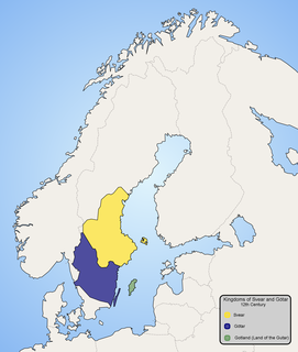
The walls seem to be constructed to protect the Geatish heartland around today's Linköping from attacks from the Baltic Sea. Archaeological excavations have shown that the walls were constructed ca 800. Defense constructions were also built along the 20-kilometer narrow inlet Slätbaken that stretches from the Baltic Sea to Götavirke, and even pass it during the Viking Age when the water level was 1.5 meters higher. The measures that Geats had taken to protect the route have no match in Viking Age Sweden. [1]

Linköping Place in Östergötland, Sweden

Linköping is a city in southern Sweden, with 158,841 inhabitants as of 2018. It is the 7th largest city in Sweden. It is the seat of Linköping Municipality and the capital of Östergötland County. Linköping is also the episcopal see of the Diocese of Linköping and is well known for its cathedral. Linköping is the center of an old cultural region and celebrated its 700th anniversary in 1987. Dominating the city's skyline from afar is the steeple of the cathedral, Domkyrka.

Baltic Sea A sea in Northern Europe bounded by the Scandinavian Peninsula, the mainland of Europe, and the Danish islands

The Baltic Sea is a marginal sea of the Atlantic Ocean, enclosed by Denmark, Estonia, Finland, Latvia, Lithuania, Sweden, northeast Germany, Poland, Russia and the North and Central European Plain.

The wall supported a wooden pale and behind it are traces of a military road, which makes it similar to the Danevirke protecting the contemporary town of Hedeby. No Viking Age towns are however known in the vicinity of Götavirke.

Danevirke

The Danevirke is a system of Danish fortifications in Schleswig-Holstein, Germany. This historically important linear defensive earthwork across the neck of the Cimbrian peninsula was initiated by the Danes in the Nordic Iron Age at some point before 500 AD. It was later expanded multiple times during Denmark's Viking Age. The Danevirke was last used for military purposes in 1864 during the Second War of Schleswig.

Hedeby city

Hedeby was an important Danish Viking Age trading settlement near the southern end of the Jutland Peninsula, now in the Schleswig-Flensburg district of Schleswig-Holstein, Germany. It is the most important archaeological site in Schleswig-Holstein.

See also

Offas Dyke Ancient earthwork in the United Kingdom

Offa's Dyke is a large linear earthwork that roughly follows the current border between England and Wales. The structure is named after Offa, the Anglo-Saxon king of Mercia from AD 757 until 796, who is traditionally believed to have ordered its construction. Although its precise original purpose is debated, it delineated the border between Anglian Mercia and the Welsh kingdom of Powys.

Related Research Articles

Lake Ladoga freshwater lake in Russia and largest lake entirely in Europe

Lake Ladoga is a freshwater lake located in the Republic of Karelia and Leningrad Oblast in northwestern Russia, in the vicinity of Saint Petersburg.

Orust Municipality Municipality in Västra Götaland County, Sweden

Orust Municipality is a municipality in Västra Götaland County in western Sweden. Its seat is located in the town of Henån, with an approximate population of 1,800.

Norsemen historical ethnolinguistic group of people originating in Scandinavia

The Norse people or Norsemen were a group of Germanic people who inhabited Scandinavia and spoke what is now called the Old Norse language between c. 800 and 1300 AD. The language belongs to the North Germanic branch of the Indo-European languages and is the predecessor of the modern Germanic languages of Scandinavia. In the late eighth century Norsemen embarked on a massive expansion in all directions. This was the start of the Viking Age.

Geats

The Geats, sometimes called Goths, were a North Germanic tribe who inhabited Götaland in modern southern Sweden during the Middle Ages. They are one of the progenitor groups of modern Swedes, along with Swedes and Gutes. The name of the Geats also lives on in the Swedish provinces of Västergötland and Östergötland, the Western and Eastern lands of the Geats, and in many other toponyms.

Södermanland Place in Svealand, Sweden

Södermanland, sometimes referred to under its Latin form Sudermannia or Sudermania, is a historical province or landskap on the south eastern coast of Sweden. It borders Östergötland, Närke, Västmanland and Uppland. It is also bounded by lake Mälaren and the Baltic Sea.

Viking ring fortress fort

A Viking ring fortress, or Trelleborg-type fortress, is a type of circular fort of a special design, built in Scandinavia in the Viking Age. They are also known simply as trelleborgs. All trelleborgs have a strictly circular shape, with roads and gates pointing in the four cardinal directions. These common structures are sometimes partially encircled by advanced ramparts, but these additions are not always circular.

Scandinavian prehistory

The Scandinavian Peninsula became ice-free around 11,000 BC, at the end of the last ice age. The Nordic Stone Age begins at that time, with the Upper Paleolithic Ahrensburg culture, giving way to the Mesolithic hunter-gatherers by the 7th millennium BC. The Neolithic stage is marked by the Funnelbeaker culture, followed by the Pitted Ware culture.

Panther–Wotan line German defense line in WW II between Germany and the USSR

The Panther–Wotan line was a defensive line partially built by the German Wehrmacht in 1943 on the Eastern Front. The first part of the name refers to the short northern section between Lake Peipus and the Baltic Sea at Narva. It stretched all the way south towards the Black Sea along the Dnieper.

Volga–Baltic Waterway series of canals and rivers in Russia

The Volga–Baltic Waterway, formerly known as the Mariinsk Canal System, is a series of canals and rivers in Russia which link the Volga River with the Baltic Sea via the Neva River. Volga–Baltic Waterway connects the biggest lake on Earth, the Caspian Sea to the World Ocean. Its overall length between Cherepovets and Lake Onega is 368 kilometres (229 mi).

Mokhovoye is a rural locality in Zelenogradsky District of Kaliningrad Oblast, Russia, located at the southwestern corner of the Curonian Lagoon.

Södertälje Canal canal

The Södertälje Canal is a canal connecting the lake Mälaren with the Baltic Sea, at the city of Södertälje. It is 5.2 km long, and it has one lock. The size of this lock is the largest in Scandinavia by allowed ship size. The lock is 135 m long and 17 m wide. The water level difference between Mälaren and the Baltic Sea is not large, on average 0.6 m (2 ft). This is the main shipping route into the lake Mälaren.

The Salme ships are two clinker-built ships of Scandinavian origin discovered in 2008 and 2010 near Salme village on the island of Saaremaa, Estonia. Both ships were used for ship burials here around AD 700-750 in the Nordic Iron Age and contained the remains of more than 40 warriors killed in battle, as well as numerous weapons and other artifacts.

Blekinge archipelago archipelago in the Baltic Sea

Blekinge archipelago is an archipelago in the Baltic Sea, located in Blekinge in the south of Sweden.

Sasanian defense lines

The defense lines of the Sasanians were part of their military strategy and tactic. They were networks of fortifications, walls, and/or ditches built opposite the territory of the enemies. These defense lines are known from tradition and archaeological evidence.

References

  1. Anders Högmer, Arkeologiskt kontaktseminarium, Jyllands Rømø 1994. Published in Marinarkeologi 1998. Article is also available online.